Kings Canyon National Park: Things to Do, Scenic Drives, Maps, Fees & More
Peter BrahanKings Canyon National Park preserves a rugged and pristine portion of wilderness in California’s Sierra Nevada Mountains. Located just north of adjoining Sequoia National Park and to the southeast of Yosemite National Park, this park features deep, glacier-sculpted canyons, waterfalls, meadows, over 20 peaks that exceed 13,000 feet and some of the largest trees in the world!
Kings Canyon National Park is our nation’s 25th national park. However, long before Kings Canyon was established, the area now known as Grant Grove was General Grant National Park. The park was established in 1890 to protect the area’s giant sequoias from logging. 50 years later, the park was renamed Kings Canyon National Park and greatly expanded to include a large area of backcountry to the east. Due to the vast size of the new park, the administration struggled to manage it, and Sequoia National Park staff often lent a hand. After World War II, the two parks were jointly administered to save money; and, today the parks are still managed as one--Sequoia and Kings Canyon National Parks.
Most of the 461,901-acre park is designated wilderness, and only accessible by trail. Kings Canyon National Park is becoming known as a premier destination for backcountry adventures. Only a small part of the park is reachable by road. The park’s most visited attractions are concentrated in two distinct areas of Kings Canyon National Park—Grant Grove and Cedar Grove. The Grant Grove Village area is a major hub of activity for tourists and accessible year-round. The much more remote Cedar Grove is nestled deep in Kings Canyon and only accessible when the Kings Canyon Scenic Byway is open--typically May through October.
Whether stopping to see roadside attractions or hitting the backcountry trails, you are sure to love Kings Canyon National Park. We hope our guide on what to see and do in Kings Canyon National Park will help you plan a memorable visit to this stunning park!
Ahead of your trip, be sure to check out our Kings Canyon National Park itinerary. It’s packed full of information on the best hikes in the park, where to stay nearby and what to pack when heading to the park. We also give you tips on what to see and do in the nearby area.
GRANT GROVE AREA
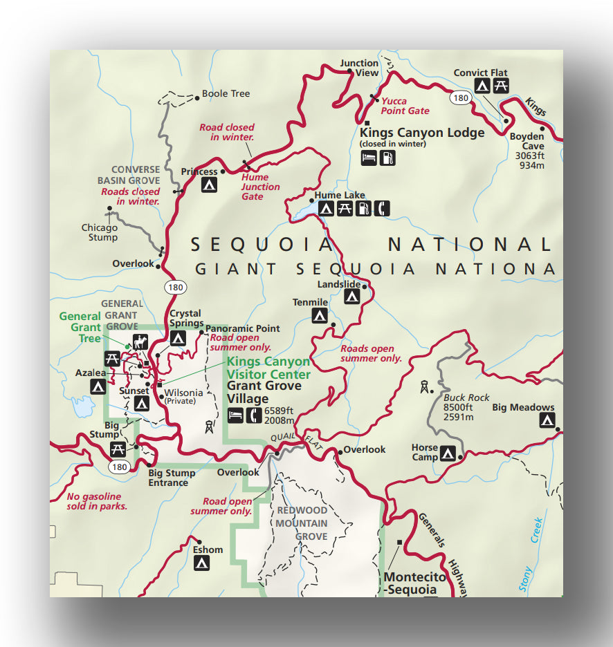
Grant Grove area map, courtesy of the National Park Service
The Grant Grove area makes up the small but most visited western portion of Kings Canyon National Park. Grant Grove Village is situated just north of the park’s Big Stump entrance on CA 180 and offers a variety of visitor services, including the main Kings Canyon visitor center, two lodging options (the John Muir Lodge and Grant Grove Cabins) and three campgrounds. Other amenities include a market, post office, gift shop and the Grant Grove Restaurant, which are all open year-round.
When visiting the Grant Grove area, our recommendations include:
- Grant Grove and the General Grant Tree. Likely the most visited attraction in the park, Grant Grove is located just a mile north of the village area. Follow the General Grant Tree Trail through a pristine sequoia grove to the grove’s namesake and centerpiece. The General Grant Tree is the largest giant sequoia in the Grant Grove area of the park, standing over 267 feet tall and 107.5 feet around at its base. In 1926, the General Grant Tree was proclaimed the “Nation’s Christmas Tree” by President Calvin Coolidge.
- This 0.5-mile paved, loop hike is the most popular hike in the park, but it is worth the stop to see one of the world’s largest living trees! Be sure to stop along the way to check out the Fallen Monarch (and read about its amazing history!), historic Gamlin Cabin and the Centennial Stump. Park at the General Grant Tree parking area on Grant Tree Road, just off CA 180.

- Panoramic Point. From Grant Grove Village, drive the narrow and windy 2.5-mile road to Panoramic Point. A 1/4-mile trail leads to the 7,526-foot ridge with stunning views of the Sierra wilderness and Hume Lake in Sequoia National Forest. Return the way you came or hike the loop trail back to the parking lot (1/2-mile roundtrip). You can also extend your hike by following the Park Ridge Trail to the Park Ridge Fire Lookout (~4.8 miles roundtrip). The road begins just behind the John Muir Lodge. RVs and trailers are not permitted, and the road is closed in winter.

- Additional Hiking in the Grant Grove Area. In addition to the short trails like the ones leading to the General Grant Tree and Panoramic Point, there a few options for longer day hikes in the Grant Grove area. To learn about these and other trail options in the Grant Grove area, stop in at the Kings Canyon Visitor Center in Grant Grove Village to pick up trail maps and ask about which hikes would be the best fit for you!
- For a less-traveled hike that still provides an up-close experience with magnificent sequoias, consider hiking the North Grove Loop. Wander past meadows and creeks on this 1.5-mile peaceful forest hike. Park at the General Grant Tree parking area.
- Another quiet hike in Kings Canyon is the Big Stump Loop Trail. This 1.8-mile loop hike, with minimal elevation gain, features stumps left from logging in the late 19th Notable trees along the trail include the Mark Twain Stump, the Sawed Tree and the Burnt Monarch. The trailhead is at the Big Stump Picnic Area just north of the Big Stump Entrance on CA 180. NOTE: Big Stump also becomes a snow play area in winter!
- Looking for a bit of a climb with panoramic views? The 2.2-mile trail to the summit of Big Baldy Ridge climbs to 8,209 feet and offers great views of Redwood Canyon. This hike is considered moderately difficult with an elevation gain of 600 feet and a roundtrip hiking distance of 4.5 miles. From Grant Grove Village, drive about 8 miles south on Generals Highway and park in the area near the Big Baldy Ridge trailhead.
- Redwood Canyon is just 6 miles south of Grant Grove and contains the largest sequoia grove in the park AND the least visited! Access to the trailhead for this area requires a 2-mile drive down a rough dirt road. However, with 16 miles of trail and several different loop options, you may just want to pack a lunch and spend the day. The Redwood Canyon Loops, consisting of two connected loop trails, is a good option if you are looking for a longer day hike with sequoia and redwood groves plus great mountain views (10.9 miles; 2,185 feet elevation gain). Other options include hiking just the Sugarbowl Loop (6 miles; 1,500 feet elevation gain) or the Hart Tree Loop (7 miles; 1,400 feet elevation gain). From Grant Grove Village, drive south on Generals Highway for 6 miles. Turn right at the sign for Redwood Canyon (across from Quail Flat Campground) and drive 2 miles down the dirt road to the parking area. This road is usually closed in the winter.
- Looking for a fairly easy hike with a big payoff? The 2-mile out-and-back Buena Vista Trail (413 feet elevation gain) leads to the boulder topped Buena Vista Peak with stunning views of Redwood Canyon and beyond. From Grant Grove Village, drive south on Generals Highway for just over 6 miles. Park at the indicated area near the trailhead to Buena Vista Peak.
KINGS CANYON SCENIC BYWAY
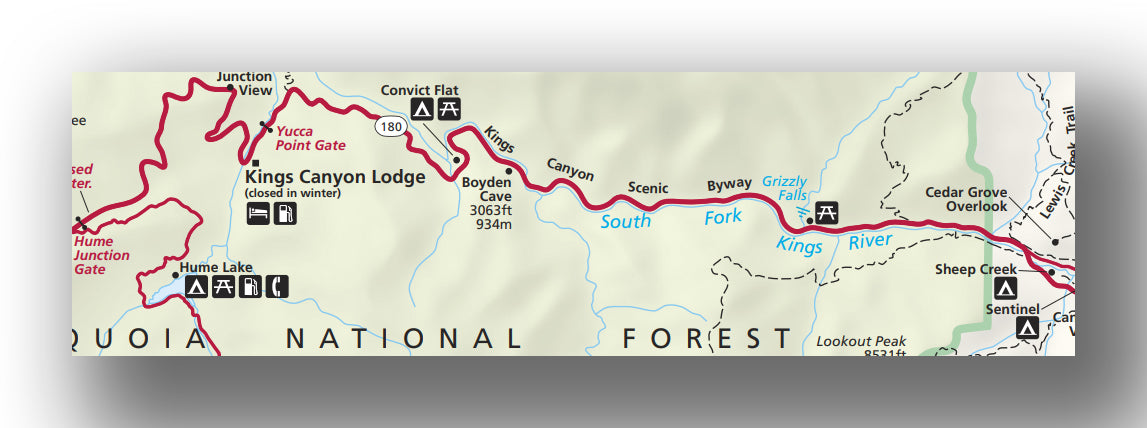
Kings Canyon Scenic Byway map, courtesy of the National Park Service
The Kings Canyon Scenic Byway (Highway 180) runs about 30 miles from the Grant Grove area and winds its way down to Cedar Grove. The two-lane road, which provides the only vehicle route into Kings Canyon, descends through Sequoia National Forest and runs along the mighty Kings River before leading to “Roads End” in the Cedar Grove area of Kings Canyon National Park.
The section of Kings Canyon Scenic Byway beyond the turnoff to Hume Lake is closed in the winter and generally only open from May through October. Be sure to check the status of the road before making spring or fall travel plans. We DO highly recommend a summer visit since a drive on the Kings Canyon Scenic Byway, into one of the deepest canyons in North America, is spectacular! Allow 2-3 hours for roundtrip travel time to and from Roads End (not including stops and hikes along the way).

When driving along the Kings Canyon Scenic Byway between Grant Grove and Cedar Grove, possible stops include the following locations:
- There are numerous scenic pullouts along the way with stunning views of Kings Canyon including Junction View (where you can see the junction of the South and Middle Forks of the Kings River), Yucca Point, Marble Mountain View, Horseshoe Bend and Canyon View.
- Located 22 miles east of Grant Grove Village in Sequoia National Forest, Boyden Cavern is a marble cave accessible by guided tours in the summer.
- Grizzly Falls is a popular photo stop just 4 miles west of Cedar Grove Village. A short dirt path leads to these falls with a 75-foot drop. Snowmelt makes them especially impressive during spring and early summer! This stop includes a small picnic area.


Read on for more amazing stops along Kings Canyon Scenic Byway located in the Cedar Grove area of Kings Canyon National Park!
CEDAR GROVE AREA
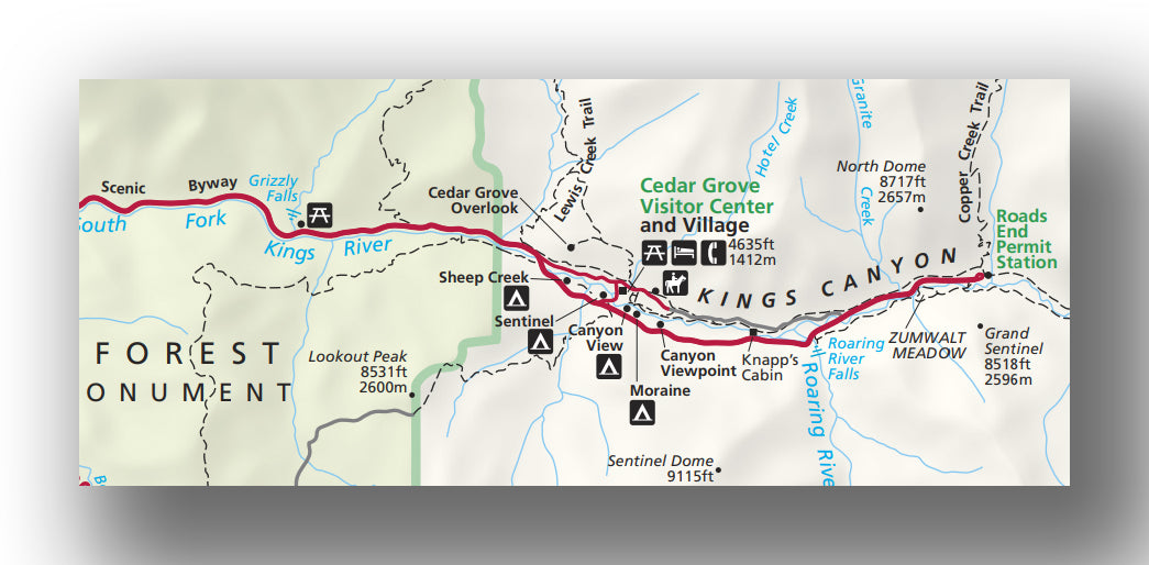
Cedar Grove area map, courtesy of the National Park Service
The remote Cedar Grove area sits deep in the heart of Kings Canyon and features towering granite cliffs, the rushing Kings River and cascading waterfalls. Two prominent rock formations, North Dome and Grand Sentinel, both rise over 8,000 feet above the canyon floor.
The Cedar Grove Visitor Center is located just off CA 180 (30 miles east of Grant Grove and next to Sentinel Campground) and is open Memorial Day to Labor Day. The small visitor center provides information about local hikes, ranger-led and night programs, plus the status of campsite availability in Cedar Grove.
At nearby Cedar Grove Village, services include the Cedar Grove Market and Snack Bar, showers, the Cedar Grove Lodge, and four area campgrounds, which are open summer to mid-fall.
When visiting the Cedar Grove area, our recommendations include:
- Knapp’s Cabin. Make a quick stop at a roadside pullout along Kings Canyon Scenic Byway to visit this historic cabin in the heart of Kings Cabin along the banks of the Kings River. Park at the pullout 2 miles east of Cedar Grove Village.
- Roaring River Falls. Follow the short, paved trail (0.3 miles) to Roaring River Falls, where the Roaring River pours through a narrow granite chute. From Cedar Grove Village, drive 3 miles east and park in the lot at the trailhead.
- Zumwalt Meadow. The Zumwalt Meadow Trail is the most popular trail in the Cedar Grove area. Sadly, heavy rains and river flooding in 2019 washed out portions of the original 1.5-mile loop trail that passed through the meadow. However, we still think this now out-and-back trail is worth the trip for views of Zumwalt Meadow, North Dome and Grand Sentinel! Follow the trail to cross the Kings River via an expansion bridge. Shortly after crossing the bridge, the trail climbs talus slopes. Be prepared for a bit of a scramble over granite boulders to reach the other side of the meadow. We recommend wearing closed toe shoes and hiking early in the morning or late in the after to avoid crowds. To extend the hike, continue beyond the meadow to where the trail merges with the Kanawyer Loop Trail. Hike another 0.8 miles towards Road’s End. From Cedar Grove Village, drive 4.5 miles east and park at the Zumwalt Meadow trailhead. Allow about an hour.


- Mist Falls. Many backcountry trails originate from Road’s End; however, for those seeking a spectacular day hike, we highly recommend the Mist Falls Trail, which leads to one of the park’s largest waterfalls. The first part of this 9-mile round trip hike is relatively flat. A sandy trail follows the South Fork Canyon through a pine forest surrounded by granite walls. Beyond the first couple miles, the trail climbs as it travels along the river. The elevation gain is minimal and gradual at first, but the trail gains 600 feet in the last mile and involves a granite staircase that leads to Mist Falls (total elevation gain over 800 feet). You can hike back after reaching the falls or continue to Paradise Valley (~13 miles roundtrip; 1500 feet elevation gain). In the spring and early summer, some of the trail can be washed out or involve water crossings; however, the cascades are also the most impressive that time of year! Just be sure to check current conditions before your visit. From Cedar Grove Village drive to Road’s End and park in the large lot. The trailhead begins just past the Road’s End Permit Station. Allow 4-5 hours for the round-trip hike.


- Additional Hiking in the Cedar Grove Area. In addition to the popular hikes listed above, there a variety of other options in the Cedar Grove area. To learn about trail options in the Cedar Grove area, stop in at the Cedar Grove Visitor Center to pick up trail maps and ask about which hikes would be the best fit for you!
- If you are looking for a hike that offers a taste of the Kings Canyon wilderness with minimal elevation gain (only about 150 feet), check out the Kanawyer Loop Trail. The 5-mile Kanawyer Loop begins at Road’s End and follows the South Fork of the Kings River upstream. At the trail junction, bear left to Bubbs Creek. After crossing the Bubbs Creek Bridge, turn right again and return to the trailhead along the other side of the river. To reach the trailhead, park at Road’s End. The trailhead begins just past the Road’s End Permit Station. Follow signs that point to Mist Falls, Paradise Valley and Bubbs Creek for the first part of the loop.
- For a challenging but lightly traveled trail, check out the 4.8-mile roundtrip hike (~1600 feet elevation gain) to Cedar Grove Overlook. Follow the Hotel Creek Trail as it climbs steep switchbacks up the south-facing side of the canyon and continue to the Cedar Grove Overlook. Your efforts will be rewarded with sweeping, panoramic views of Kings Canyon and the Monarch Divide to the north. Much of the trail has full sun exposure, so be sure to hike this one early in the morning! To reach the trailhead, drive past the Cedar Grove Visitor Center and Village and turn right at the fork.
- Once the main access route into Kings Canyon (before the highway opened in 1939), the Don Cecil Trail is a challenging but lightly traveled trail in Kings Canyon. This steep and strenuous 12-mile round trip hike (3,300 feet elevation gain) offers a summit meadow with panoramic views of the canyon. An easier target for those looking to hike a portion of the Don Cecil Trail is the Sheep Creek Cascade, a series of waterfalls in a mossy ravine (2-mile roundtrip with about 600 feet elevation gain). Park at the Cedar Grove Visitor Center and follow signs to the trailhead across Highway 180.
- If you are hoping to head to the Kings Canyon backcountry on an overnight trip, be sure to reserve permits in advance. One of the most popular backpacking trails in the Sierra Nevada, the Rae Lakes Loop, is accessed from Road’s End. Permits for trails that begin in Cedar Grove can be picked up Road’s End Wilderness Permit Station.
OTHER ACTIVITES IN KINGS CANYON NATIONAL PARK
- Guided horseback rides are offered in both areas of the park. Both Grant Grove Stables and the Cedar Grove Pack Station offer short trail rides and pack trips for those looking to explore Kings Canyon on horseback.
- Give fly fishing a try with Sierra Fly Fisher, the first NPS-approved guide service to be permitted to fish in Sequoia and Kings Canyon National Parks.
DIRECTIONS TO KINGS CANYON NATIONAL PARK AND OTHER TRAVEL INFORMATION
Take CA 180E from Fresno to the Big Stump entrance of Kings Canyon National Park. This route is also the alternate way into Sequoia National Park for those with larger vehicles, since it is a straighter and less steep route than CA 198.
- Fresno to Kings Canyon National Park: ~ 1 hour 15 minutes; 55 miles
- San Francisco to Kings Canyon National Park: ~4 hours 30 minutes; 240 miles
- Sacramento to Kings Canyon National Park: ~4 hours 15 minutes; 240 miles
- Yosemite National Park (Mariposa Grove) to Kings Canyon National Park: ~ 2 hours 30 minutes; 115 miles
Travel times between park areas (without stops):
- Giant Forest area (Sequoia NP) to Grant Grove (Kings Canyon NP): ~1 hour
- Grant Grove to Cedar Grove (Kings Canyon NP): ~ 1 hour
The Big Stump entrance is open year-round; however, tire chains may be required at any time between fall and spring when snow or ice makes road travel hazardous. Be sure to verify road conditions and closure status before winter travel.
WHERE TO STAY IN KINGS CANYON NATIONAL PARK
Kings Canyon National Park Lodging: There are three lodging options inside Kings Canyon National Park—the John Muir Lodge (where we stayed for a couple nights), the Cedar Grove Lodge and the Grant Grove Cabins. All but the Cedar Grove Lodge are open year-round. The Cedar Grove Lodge is only open May to mid-October. Be sure to make reservations well in advance.


Kings Canyon National Park Camping: There are seven campgrounds inside Kings Canyon National Park (and seven more at neighboring Sequoia National Park). Most campgrounds operate on a first-come, first-served basis. During holidays and summer weekends, campgrounds fill faster than usual, so arrive early if you are planning to camp inside the park. Details on campgrounds in Sequoia and Kings Canyon National Parks can be found here, or you can check out our blog on the Best Campgrounds in Sequoia National Park.
There are also several campgrounds in Sequoia National Forest, which borders Sequoia and Kings Canyon National Parks.
BEST TIME TO VISIT KINGS CANYON NATIONAL PARK
Kings Canyon National Park is open year-round, but the best time to visit depends on what you want to see and do during your visit! The weather in Kings Canyon National Park varies widely by season and elevation. The busiest months in Kings Canyon are June through August when all parks roads and most trail are typically open.

At higher elevation (6,600 feet), the Grant Grove area experiences much cooler temperatures than surrounding valleys. Summer brings warm days and cool nights. However, winter is characterized by cold temperatures and deep snow. Snow play areas can be found at Big Stump and Columbine. If there is sufficient snow, many trails in the Grant Grove area are suitable for snowshoeing and cross-country skiing!
At a lower elevation, the Cedar Grove area (4,600 feet), experiences much warmer temperatures than Grant Grove, especially during summer months. However, this area is only accessible when Highway 180 is open—typically May through October. If access to this area is a high priority during your visit, be sure to plan a trip during those months.
For more information on Kings Canyon National Park weather, check the NPS website or the National Weather Service website.
Although accessible areas of the park, like Big Stump and Grant Grove, are beautiful in the winter, be prepared for snowy and icy roads. Tire chains are often required to travel on some park roads anywhere between fall and spring when snow is possible. Check current road conditions in the park before travel.
TIPS FOR VISITING KINGS CANYON NATIONAL PARK
- Fill up your gas tank before entering the park. There are no gas stations within park boundaries. Gas is available year-round at Hume Lake (near Grant Grove) or Stony Creek Village (summer only) in Sequoia National Forest.
- Cell service is extremely limited in the park but is available near the main entrance stations. Public Wi-Fi is available at the Kings Canyon Visitor Center in Grant Grove.
- Pets are allowed in campgrounds and picnic areas but must be always kept on a leash and cannot be left unattended at a campsite. Although pets are not permitted on any trails at Kings Canyon (or Sequoia) National Park, they are allowed (on a leash) on trails at Sequoia National Forest.
- Dining and food options are limited inside the park. Grab-and-go food is available at Grant Grove and Cedar Grove Villages. Be sure to pack food and plenty of water for the day. We love having a picnic lunch or dinner inside a national park! Just be sure to pack out all trash and food waste (including apple cores, banana peels, etc.).

RELATED INFORMATION ON KINGS CANYON NATIONAL PARK FROM JUST GO TRAVEL STUDIOS
- Aside from our Kings Canyon National Park Itinerary, we highly recommend checking out our blogs on some of our favorite spots in Kings Canyon National Park, including Hiking the Zumwalt Meadow Trail in Kings Canyon National Park and the Best Hikes in Kings Canyon National Park.
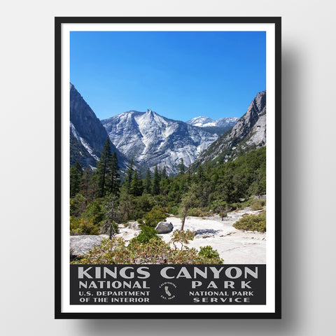
- We have a Kings Canyon National Park Poster in our WPA collection which are worth checking out!
- When you return from your trip, don’t forget to contact us so we can create a custom, vintage style travel poster! We love making these posters, and are confident you’ll love the results!


