Sequoia National Park: Things to Do, Weather, Maps, Fees & More
Amy BrahanLocated in the southern end of California’s Sierra Nevada mountain range, Sequoia National Park draws well over a million visitors a year. The Giant Forest area of the park is home to some of the world’s largest trees by volume, including the General Sherman Tree, the largest tree on the planet! Although giant trees are the main attraction, Sequoia National Park is also a great destination for your next wilderness adventure. Hikes and attractions in the park, and in neighboring Kings Canyon National Park, can keep you busy for days.

Sequoia, our nation’s second national park, is filled with opportunities to explore nature. Walk among towering sequoias, hike to a remote peak or tour an underground cave. Whether you have a single day to visit or plan an extended stay, Sequoia National Park is sure to amaze visitors of all ages. And, with scenic Generals Highway connecting Sequoia to Kings Canyon National Park, you can visit two amazing parks in one trip!
We hope this guide on what to see and do in Sequoia National Park will help you decide how to best spend your time in the park!
Be sure to check out our downloadable Sequoia National Park itinerary, which covers all the best hikes, where to stay and what to do in the area (and the surrounding geography). Having a copy of this in a park without cell service is a must!
GIANT FOREST AND LODGEPOLE VILLAGE
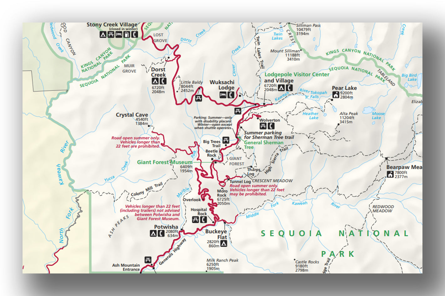
Giant Forest map, courtesy of the National Park Service
Giant Forest and nearby Lodgepole Village are the most popular areas of the Sequoia National Park since they comprise the greatest concentration of easily accessible points of interest. Our favorite Sequoia National Park hikes are found in these two areas.
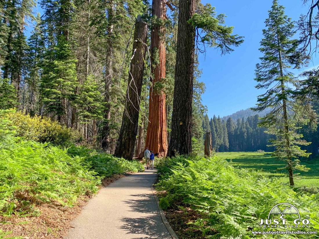
Giant Forest has the most impressive collection of the park’s namesake trees and is home to the largest living tree on earth by volume. To fully appreciate the sequoias’ massive size, you must get out of your car to walk among the giants! With a large parking area, the Giant Forest Museum (open year-round), summer shuttle service and access to numerous trailheads, Giant Forest is a great area from which to begin your hiking adventures in the park.
Lodgepole Village also offers parking and shuttle service (summer), as well as the seasonal Lodgepole Visitor Center and Lodgepole Market. In July and August, the Walter Fry Nature Center, located east of the visitor center at Lodgepole Campground, offers hands-on exhibits, games and campfire programs for children.

When visiting the Giant Forest and Lodgepole areas, our recommendations include:
- Giant Forest Museum. The museum is a great starting point and provides information on the giant sequoias and the natural history of the park. Talk to a park ranger and grab a trail map to head out on the surrounding trails. From the end of May to early September, avoid the hassle if finding a parking spot and take advantage of free park shuttles, which run from Giant Forest Museum to other locations in the park. Park at Giant Forest Museum lot off Generals Highway.
- Moro Rock/Crescent Meadow Road. Wind through the Giant Forest Sequoia Grove on this narrow and windy road. Stops along the way include Auto Log, the Parker Group, and Tunnel Log. Moro Rock/Crescent Meadow Road is closed in the winter. It is also closed to private vehicles on summer weekends and holidays when the park shuttle is in operation (from 8 am to 6 pm).
- Auto Log was a popular photo op in the 1930s, but you can no longer drive over this fallen sequoia. However, you can still make a quick stop and take a photo.
- The Parker Group is an easily accessible cluster of giant sequoias right near the edge of the road. This was our first up-close experience with these amazing trees. Until you stand next to them, you can’t really comprehend their size!
- Drive or walk through Tunnel Log. If your vehicle is less than 8 feet tall, you can drive through this fallen sequoia. This enormous tree, 275 feet tall and 21 feet at the base, fell across the road in 1937. A tunnel was cut through the tree a year later, and visitors have been driving through it ever since. A bypass lane is available for larger vehicles and the shuttles. This is the only tree you can drive through in the park.
- Hiking. There are a variety of trails in Sequoia National Park for all ages and abilities. Many of the best short trails and day hikes are located just off Generals Highway in the Giant Forest and Lodgepole areas. We recommend the following hikes:
- Moro Rock is one of the most popular trails in the park, but you won’t want to miss it! Climb 400 steps to the summit of this granite monolith to get some of the best views of the Great Western Divide and the Kaweah River canyon far below. The hike is short but challenging for some due to the steep steps (300 feet elevation gain in the 1/4-mile climb to the summit). The Moro Rock parking lot is off Moro Rock/Crescent Meadow Road. Closed in winter. Accessible by park shuttle only on summer weekends and holidays.


- A variety of hiking trails circle and branch from Crescent Meadow at the end of Moro Rock/Crescent Meadow Road. However, the Crescent and Log Meadows loop trail is one of our favorites in the park! This relatively flat, and easy 1.8-mile hike is great for the whole family! Enjoy two beautiful meadows, towering sequoias, Tharp’s Log (historic summer cabin built into a fallen Sequoia) and Chimney Tree (fire-hollowed but still standing sequoia). Moro Rock/Crescent Meadow Road closed in the winter.


- If you are short on time, Big Trees Trail, near Giant Forest Museum, is great way to see some amazing sequoias and a beautiful meadow. A 2/3-mile (mostly paved and boardwalk) interpretive trail circles Round Meadow. Park at Giant Forest Museum parking lot. Trail from Giant Forest Museum is just over 1-mile roundtrip. Wheelchair accessible (parking available at trailhead with disability placard).

- Standing at 275 feet tall and measuring over 36 feet in diameter at the base, the General Sherman Tree is the world’s largest tree by volume and one of the main attractions at Sequoia National Park. Two trails lead to the General Sherman Tree in the north end of the Giant Forest. For the Main Trail, park at the lot off Wolverton Road. This paved trail (which includes stairs) descends a 1/2 mile downhill through the Giant Forest sequoia grove before reaching the General Sherman Tree. The trail is short but does require an uphill hike to return to the parking area. A wheelchair-accessible trail is also available from a small lot (and shuttle stop) along the edge of Generals Highway. This short trail leads a few hundred feet from the parking area to the General German Tree. During weekends and the busy summer season, be prepared for a long line if you’d like to take a photo in front of the tree.

- If you have more time, combine a hike to the General Sherman Tree with the 2-mile Congress Trail (3-mile roundtrip hike from the main parking area). As the Congress Trail travels into the depths of the Giant Forest and away from the General Sherman Tree, crowds thin significantly. The President Tree, the world’s third largest tree, is one of the many giants located along the Congress Trail.
- If you are visiting the Lodgepole area, enjoy a hike along the Kaweah River and then scramble over granite boulders to reach the tallest water fall in Sequoia National Park, Tokopah Falls. The 4.0-mile out-and-back hike is considered on the easy end of moderate due to an elevation gain of about 600 feet over 2 miles. Water flow is the most impressive in early summer due to snow melt. The Tokopah Falls Trailhead begins inside the Lodgepole Campground, just beyond the Marble Fork Bridge.

To learn about other hikes and trail options in the Giant Forest and Lodgepole areas, stop in at the Giant Forest Museum or Lodgepole Visitor Center to pick up trail maps and ask about which hikes would be the best fit for you!
FOOTHILLS AREA

Foothills area map, courtesy of the National Park Service
The Foothills Visitor Center is located just beyond the Ash Mountain entrance at the southern end of the park and is open year-round. The golden foothills (at 1,700 feet elevation) are home to a rich assortment of plant and wildlife. This low country consists of oak woodlands, chaparral, grasslands, yucca and steep river valleys.
Here are a few recommendations in the area:
- The iconic Tunnel Rock pullout off Generals Highway is a popular photo stop on the way into the park. This granite tunnel, created in the 1930s by the CCC, was the old route into the park until the highway was widened in 1997. The NPS asks visitors not to climb on the rock. Poison oak is common in the area.

- At the Hospital Rock Picnic Area (about 4 miles northeast of the Foothills Visitor Center), stop to see pictographs made by the California Native Americans who once lived here and view exhibits about the region’s history.
- Hiking. There aren’t many hikes in this area but there is one worth mentioning if you are up for a longer hike:
- The moderate hike to Marble Falls (about 7.5 miles roundtrip and 1600 feet elevation gain) begins from Potwisha Campground (about 3 miles northeast of the Foothills Visitor Center). The trail climbs steadily up a mountain canyon to Marble Falls at the end. Spring wildflowers and comfortable temperatures make this a great hike from late March to May.
CRYSTAL CAVE
Sequoia and Kings Canyon National parks combined protect at least 275 caves. However, the only cave inside Sequoia National Park open to the public is Crystal Cave, located near Giant Forest. Explore the subterranean side of Sequoia via a guided tour through this marble karst cave with an assortment of striking stalactite and stalagmite formations.
What to know before you go:
- Crystal Cave is only open late May through September. Reserve cave tour tickets online at least two days in advance, or earlier if planning to visit on a weekend or holiday (since tickets commonly sell out). Already in the park? Stop in first thing in the morning at the Lodgepole or Foothills visitor centers to purchase tickets, when available. Cave tour tickets are NOT available for purchase at the cave.
- To reach the cave, you must drive 7 miles to the end of the narrow and winding Crystal Cave Road (located 2 miles south of the Giant Forest Museum). Maximum vehicle length is 22 feet.
- Use the parking lot restrooms before hiking down to the cave entrance. There are no bathrooms at the cave.
- Wear sturdy shoes. From the parking area, you’ll hike down a steep 1/2-mile path to reach the cave.
- Bring a jacket. Temperatures inside the cave are about 50 degrees.
- Strollers, tripods and bags/backpacks are not allowed inside the cave. Leave those locked in your car.
For more information on Crystal Cave, see the NPS website.
MINERAL KING

Mineral King map, courtesy of the National Park Service
The Mineral King area is only open late May to October (weather permitting) and can be reached via a 25-mile narrow and winding road. Turn off SR-198, 2 miles before the park entrance (if coming from outside the park) and follow Mineral King Road as it climbs 6,600 feet to a sub-alpine valley.
Mineral King is the only car-accessible part of Sequoia’s backcountry. For the serious hiker and backpacker, this area is hiker heaven since there are plenty of hikes from which to choose. However, most of the hikes are steep and the alpine trails begin at high elevations posing a challenge for some.
These are a couple options for hikes in Mineral King:
- The easy, 2-mile out-and-back Cold Springs Nature Trail starts at the Cold Springs Campground and is great for all ages. Interpretive signage along the trail provides a good introduction to alpine vegetation typical in the Mineral Springs area.
- The trailhead for Eagle Lake begins at the end of Mineral King Road at the Eagle-Mosquito Parking Area. Eagle Lake Trail is a challenging 7.2-mile hike with 2175 feet elevation gain. However, if you can manage the steep, uphill climb, the pay-off is big!
- The 8.4-mile out-and-back trek to Lower Monarch Lake starts from the Sawtooth Parking Lot on the north end of Mineral King Valley. The hike to Monarch Lakes (via Sawtooth Pass Trail) is another challenging climb with 2,650 feet of elevation (much of it in the first mile) but leads to a beautiful subalpine lake with amazing views.
WARNING: From spring to mid-summer, the resident Mineral King marmots have been known to chew through radiator hoses and electrical wiring on the cars of unsuspecting visitors and hikers. The NPS recommends driving over a tarp, wrapping it around your vehicle and covering wheel wells.
MOUNT WHITNEY
In addition to being home to the world’s largest tree by volume, Sequoia National Park also has the tallest mountain in the contiguous United States. At 14,494 feet tall, majestic Mount Whitney crowns the Sierra Nevada. Mount Whitney can only be seen from Highway 395, near Lone Pine, outside the eastern border of the park.
Experienced hikers and climbers can take on Mount Whitney through a variety of routes. The most direct route to the summit is from the east side of the Sierra Nevada. The 22-mile roundtrip hike from Whitney Portal takes one to two days and requires a permit (based on a lottery system) from the U.S Forest Service. Western trailheads require multi-day treks and a wilderness permit from the National Park service.
DIRECTIONS TO SEQUOIA NATIONAL PARK AND OTHER TRAVEL INFORMATION
There are two main ways to get to Sequoia National Park: CA 198 from Visalia into Sequoia or CA 180 from Fresno into Kings Canyon. CA 198 passes through Visalia and Three Rivers before reaching the Ash Mountain entrance to Sequoia National Park. The scenic drive from Visalia to the Ash Mountain Entrance takes about 45 minutes (36 miles).
Travel Directions from southern California to Ash Mountain entrance:
- Los Angeles to Sequoia National Park: ~ 4 hours; 225 miles
- San Diego to Sequoia National Park: ~ 6 hours 30 minutes; 325 miles
If you are traveling from northern California, take CA 180E from Fresno to the Big Stump entrance of Kings Canyon National Park. Then, follow Generals Highway to Sequoia National Park. However, if coming from this direction, we highly recommend first spending some time in Kings Canyon National Park!
Travel Directions from northern California to Kings Canyon Big Stump entrance:
- Fresno to Kings Canyon National Park: ~ 1 hour 15 minutes; 55 miles
- San Francisco to Kings Canyon National Park: ~4 hours 30 minutes; 240 miles
- Sacramento to Kings Canyon National Park: ~4 hours 15 minutes; 240 miles
- Yosemite National Park (Mariposa Grove) to Kings Canyon National Park: ~ 2 hours 30 minutes; 115 miles
Both highways are open year-round; however, tire chains may be required at any time between fall and spring when snow or ice makes road travel hazardous. Winter storms also bring occasional closures the to the section of road between Giant Forest and Grant Village. Before traveling to Sequoia National Park in winter, check current road conditions and know the expectations for winter driving in the park.
If you are flying into the area to visit the park, then you’ll want to check out our blog on the Best Airports for Sequoia National Park.
WHERE TO STAY IN SEQUOIA NATIONAL PARK
Sequoia National Park Lodging: The only lodge inside Sequoia National Park is the Wuksachi Lodge. There are a few lodging options at neighboring Kings Canyon National Park—the John Muir Lodge (where we stayed for a couple nights), the Cedar Grove Lodge and the Grant Grove Cabins. All but the Cedar Grove Lodge are open year-round. The Cedar Grove Lodge is only open May to mid-October. Be sure to make reservations well in advance.

Sequoia National Park Camping: There are seven campgrounds inside Sequoia National Park (and seven more at neighboring Kings Canyon National Park). There are also several campgrounds in Sequoia National Forest, which borders Sequoia and Kings Canyon National Parks. Details from the National Park Service on campgrounds in Sequoia and Kings Canyon National Parks can be found here.
If you are camping with an RV or trailer, check vehicle-length limits before your visit. The 12-mile stretch of road between Potwisha Campground and Giant Forest Museum is narrow and very windy. Vehicles longer than 22 feet will need to access the park via the northern route CA 180, which has fewer curves.
BEST TIME TO VISIT SEQUOIA NATIONAL PARK
Sequoia National Park is open year-round, so the best time to visit depends on what you want to see and do during your visit! The weather in Sequoia National Park varies widely by season and elevation.
Lower elevations, like the Foothills, are hot and dry in the summer (with temperatures ranging between the 60s and 90s) but mild in the winter (30s to 50s). Middle elevations, like Giant Forest, have mild summers (with temperatures ranging from the 50s to 70s). Winters are cold (with temperatures ranging from the 20s to 40s) and tend to receive a lot of snowfall causing closures to some park roads.
The busiest months in Sequoia are June-August when some wildflowers are in bloom and waterfalls are roaring. All park roads are accessible in the summer, and there is an abundance of park activities and hikes from which to choose.
If you prefer to avoid the crowds and high-priced lodging, then September to October might be your best bet. However, by mid to late October, snow begins to fall, and facilities begin to reduce hours or close altogether. Areas like Mineral King and Cedar Grove (Kings Canyon National Park) are closed and inaccessible during the snowy season (generally from late October/early November to May).
Winter brings snow to the Sequoia groves. If you enjoy solitude and don’t mind cold weather, winter is a great time to explore Giant Forest! Winter activities in the park include cross-country skiing and snowshoeing.
Spring is a great time to visit the Foothills since it brings warm weather and abundant wildflowers; however, spring weather varies widely at higher elevations in the park and late spring snowstorms are common.
TIPS FOR VISITING SEQUOIA NATIONAL PARK
- There are no gas stations within the park. Fill up your tank before entering the park or at Hume Lake or Stony Creek (summer only) in Sequoia National Forest.
- Phone service is limited within the park. If traveling with others, plan meeting times in advance. Cell service is available near the main entrance stations. Public Wi-Fi is available at the Foothills Visitor Center and at the Kings Canyon Visitor Center (Grant Grove).
- Pets are not allowed on any trails at Sequoia and Kings Canyon National Parks. In campgrounds and picnic areas, they must always be kept on a leash (less than 6 feet) and cannot be left tied and unattended at any time. In Sequoia National Forest, they are allowed on trails but must be kept on a leash.
- If staying outside the park, plan an early start, especially during busy summer weekends and holidays, to avoid long waits at entrance stations and congestion at popular parking areas.
- Food options are limited inside the park, so plan ahead and pack food and plenty of water for the day. Packing a picnic lunch and/or dinner is our favorite way to eat in the park. Just be sure to follow Leave No Trace principles and pack out your trash and any food waste (including apple cores, banana peels, etc.).
- Stay alert for bears, use metal food storage boxes when available in campgrounds and keep a safe distance from all wildlife.
SEQUOIA FACTS
- In volume of total wood, giant sequoias are the most massive trees in the world. It is easy to see why when taking in the girth of the tree--which remains thick high into the branches. Their trunks can grow as large as 40 feet in diameter and their largest branches up to 8 feet in diameter!
- Although they aren’t the tallest trees in the world, their height is still impressive. Most sequoias tower a couple hundred feet above the forest floor, but a few rare sequoias have grown over 300 feet tall. That’s as tall as a 26-story building!
- Giant sequoias are among the world’s oldest trees, and some have lived more than 3,000 years!
- They are also some of the world’s hardiest trees. The sequoias’ dense and fibrous bark, which can grow to 31 inches thick, makes them flame resistant and insulates against the heat of a fire. Additionally, a chemical called tannin in their bark gives them resistance to fungal rot and wood-boring insects.
- Giant sequoias have a shallow and wide spreading root system and no taproot, unlike most trees. It is truly amazing that such a shallow root system can support these massive trees! Root damage, strong winds and soil moistures can lead to toppling which is the primary cause of death for these trees.
- Today, giant sequoias only grow naturally in a narrow strip on the western slope of the Sierra Nevadas, between 4,000 and 8,000 feet in elevation. This area has the ideal climate for their growth. Within Sequoia and Kings Canyon National Park boundaries, there are about 40 different groves, plus another three in Yosemite National Park and others in Sequoia National Forest.
OTHER INFORMATION ON SEQUOIA NATIONAL PARK AND THE SURROUNDING AREA
- Sequoia is a great place to visit anytime of year, but you need to be prepared if you go in the winter. Antonina has a great article to help you out, Visiting Sequoia National Park in the Winter.
RELATED INFORMATION ON SEQUOIA NATIONAL PARK FROM JUST GO TRAVEL STUDIOS
- In addition to our Sequoia National Park itinerary (which will really help out since cell service doesn’t exist in the park), we also recommend viewing our blogs on the best Sequoia National Park Campgrounds and the Tokopah Falls Trail or Hiking the Moro Rock Trail in Sequoia National Park. We also have a blog dedicated to exploring Crescent Meadows.
- If you are flying into the area to visit the park, then you’ll want to check out our blog on the Best Airports for Sequoia National Park.
- Come check out our vintage Sequoia National Park posters as well.

- If you like vintage posters, then you’ll love our service where we take a photo that you send to us and turn it into a custom, vintage travel poster. Trust us, you’ll love it!