Taggart Lake Trail in Grand Teton National Park
Peter BrahanThere is so much to explore in Grand Teton National Park, which can make it hard to pick out the best places to hike. If you have limited time, it can be especially difficult to choose the right places to spend your precious days. Certainly, the Jenny Lake area is not to be missed, but south of Jenny Lake is the smaller but magical Taggart Lake. This secluded lake offers incredible, close-up views of the Grand Tetons. Being a relatively easy hike for families, we think that this is one that is not to be missed!
TAGGART LAKE WITH BEAVER CREEK LOOP TRAIL DETAILS
- Difficulty: Easy to moderate
- Distance: 3.9 miles (round-trip)
- Trail: Loop
- Elevation gain: 459 feet
- Peak elevation reached: 7,038 feet
- Best time of year to hike: Late spring to fall
- To beat the crowds: Arrive before 7:30 am or after 3:30 pm
- Footwear: Hiking boots
- Watch out for: Mosquitoes, bears, sun exposure
- Restrooms: Located at the trailhead, but not on the trail
- Pets: Not allowed
- Time needed: 2 hours

Taggart Lake Trail Map from the National Park Service

The Taggart Lake Trail is one of many hikes and sights highlighted in our 14+ page itinerary for Grand Teton National Park.
PARKING AND TRAILHEAD FOR THE TAGGART LAKE TRAIL

To access the trail, park at the Taggart Lake Trailhead on Teton Park Road. The trailhead is about 4.8 miles south of the Jenny Lake Visitor Center, and 3.5 miles north of Moose Junction (which is the intersection of the Teton Park Road and Highway 191). It is also 3.0 miles north from the Craig Thomas Discovery and Visitor Center.
- Directions from the Jenny Lake Visitor Center to the Taggart Lake Trailhead (this will take about 8 minutes, even if there is heavy traffic).
- Directions from Jackson, WY to the Taggart Lake Trailhead (this will take about 25 min, without the traffic to enter into the park).
There are right around 60 parking spaces available in the lot along with roadside parking. Be advised that this is a popular trail, and the parking lot tends to fill up quickly. Hikers start arriving at the trail early in the morning, and by 9:00 AM on a busy day you’ll likely be parking on the road and starting your hike on the pavement!
The parking lot also has restroom facilities (pit toilets with hand sanitizer).
TAGGART LAKE TRAIL: TRAIL SURFACE AND ACCESSIBILITY
- Trail surface. The trail is packed dirt or packed gravel. If you do want to get some great shots near the lake you will want to walk on a few rocks, but as long as you have good footwear you will have no problem.
- Accessibility. While the trail is not too difficult, it is not wheelchair accessible.
PREPARATION FOR HIKING THE TAGGART LAKE TRAIL
- Water. The elevation at Taggart Lake is 6902 feet above sea level. This means that the air may be thinner than you are used to. Take frequent breaks and drink plenty of water while you are out exploring this trail.
- Sun Protection. Be sure to be ready for sun exposure even though some of the hike is in and out of the cover of the trees. This trail is beautiful during all times of the day, but for the best photos, we recommend taking the hike in the morning to avoid the sun washing out the Tetons.
- Bear Spray. Grand Teton National Park is full of wildlife, with bears and moose roaming the mountains and forests. We highly recommend bringing bear spray and knowing how to use it. Don’t be afraid to make noise while you are hiking as well to avoid surprising any animal.
THE HIKE TO TAGGART LAKE

After reading the signage and leaving the parking lot, the trail intersects the Taggart Lake – Beaver Creek loop.

Continue to the north (right) alongside the wooden fence. This part of the trail is open and is more like a connecting path from the parking area to the trail.

Once you get past the fence and walk through the woods for only a minute, the trail quickly arrives at a bridge that crosses Taggart Creek. Taggart Creek feeds Taggart Lake with glacial runoff, starting from Lake Taminah and flowing through Avalanche Canyon. The creek roars in the spring and early summer in particular, with a waterfall that is visible just upstream from the bridge.

The trail climbs a total of 459 feet during the entire loop, with over half of the ascent coming in the half mile after crossing Taggart Creek. During the climb, the trail winds quickly through a beautiful aspen forest, followed by hiking in the open among a mixed forest (spruce, pine and fir) and open fields. The Tetons remain visible along the entire route, making for a wonderful backdrop throughout the hike.


The trail flattens out as it comes to an intersection with a trail to Bradley Lake, which is 1.2 miles into the journey. If you want to hike to Bradley Lake as well, you’ll add about 2.3 miles to the journey, and about 250 feet of additional climbing. Stay left to head to Taggart Lake, which is less than a half-mile ahead.
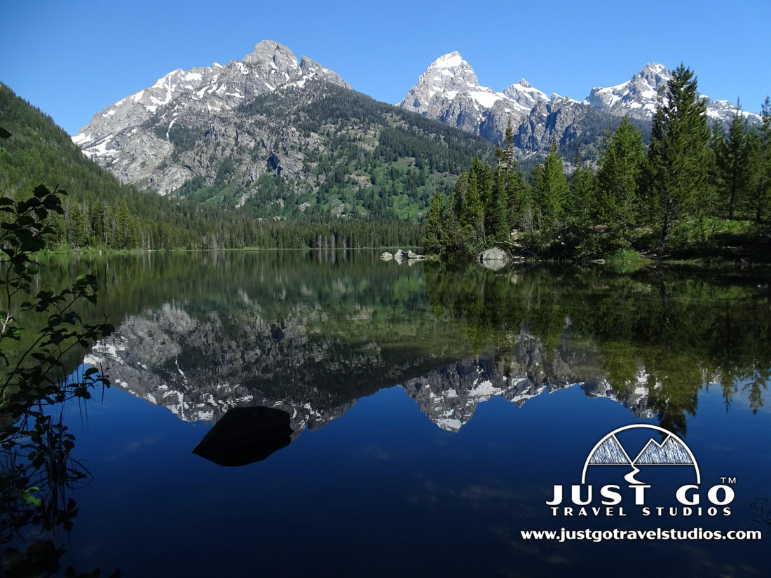
TAGGART LAKE
Taggart Lake is a “pristine” lake (meaning that it has not yet been harmed by air pollution). It won’t take us to tell you how pristine this lake really is. The views of the Teton range are amazing. Once you are here, take time to find a spot for yourself and just take in the scenery. We happened to be there when there was no wind, which created a mirror-like image on the water.


THE HIKE BACK FROM TAGGART LAKE ON THE BEAVER CREEK LOOP
To depart from Taggart Lake, you can head directly back down the same trail that you came from, which many people do. However, the Beaver Creek loop is our recommended way back due to the change of scenery and fewer crowds. To get to the Beaver Creek Loop, just continue left after you arrive at Taggart Lake. You’ll quickly come to a long, log bridge which is great for pictures.

After a brief climb of about 100 feet, the trail continues downhill for the rest of the way. After about 0.8 miles, the trail comes to a junction-stay left to head to the parking lot. The rest of the trail passes through a combination of evergreen forest and open meadows. When we hiked, we didn’t see any other people on this part of the trail (but don’t expect to get so lucky)!

Be sure to look behind you on the way down-the view of the Tetons does not get old! One advantage of heading back via the Beaver Creek Trail is the panoramic views to the east.

After traveling a total of 2 miles from Taggart Lake, the trail arrives back at the parking lot.
TAGGART LAKE TRAIL: TOP LIKES AND DISLIKES
Likes:
- Incredible Pictures. You don’t have a view of the Tetons for the entire hike, but when you do get to Taggart Lake you can get simply amazing photos. We were lucky enough to be here when the wind was still, making it perfect for pictures with reflections.
- Convenient. We found ourselves passing near this trail several times during our visit, meaning that if you see the parking lot not too full that you can just grab a spot and start hiking. Also, if you happen to get to the trail when it is too crowded you can do something else and then come back later.
- Quiet Loop. Most people don’t hike on the Beaver Creek side to make it a loop, meaning that once we got past the lake it was very quiet and peaceful. There are also great views on the way down.
Dislikes:
- Nothing. We loved this trail-there really is nothing to dislike!
THINGS TO DO NEAR THE TAGGART LAKE TRAIL
There is a ton to do in this area and you can see some ideas in our blog on What to See and Do in Grand Teton National Park. Here are a couple of tips:
- You need to be sure to visit Mormon Row, where there are about 30 standing barns from an early settlement. This is a great place to walk around and take some amazing photos as well.
- Jenny Lake is a great place for kayaking and boating.
- We loved our hike to the Cascade Canyon. This will take the better part of the day, but it remains as one of our favorite hikes of all time.
FURTHER INFORMATION ON GRAND TETON NATIONAL PARK FROM JUST GO TRAVEL STUDIOS
- The Taggart Lake and Beaver Creek Trail is one of many hikes outlined in our 14+ page itinerary for Grand Teton National Park.
- For details on how to plan your trip, see our blog on Grand Teton National Park – What to See and Do.
- The Cascade Canyon Trail (with Hidden Falls and Inspiration Point) Trail was covered in depth in another blog post-check out details on this “must do” hike as well!
- In our blog post Grand Teton – What to Pack, we cover basics on what you may want to include in your luggage when you plan a trip to Grand Teton National Park.
- Taggart Lake was one of the hikes featured in our blog on the 5 Best Day Hikes in Grand Teton National Park.
- Our son wrote up a blog post on Grand Teton in 2017. Check out his perspective on the area as well!
- Grand Teton National Park was highlighted in our blog post on the best Family Friendly Hikes in U.S. National Parks. Read the blog to find out about another favorite family hike in the park.
- We create custom, vintage-style posters, postcards and note cards from your photos of Grand Teton National Park. Check out our process!

OTHER USEFUL LINKS ON GRAND TETON NATIONAL PARK
- If you are looking for great hikes for anyone, then check out this article: 6 Best Hikes in Grand Teton National Park that Anyone Can Do!
- The National Park Service has an excellent website on Grand Teton National Park. It is a wealth of information. Be advised, though, that cell service in the park is very limited, so make sure you do your planning ahead and get all you need before you leave!
- To get some tips on great places to go for pictures within Grand Teton National Park, PhotoJeepers has a great article.
- For several tips on how to enjoy this park as a family, check out Allison’s post on Family Activities in Grand Teton National Park.

