5 Best Day Hikes in Grand Teton National Park: Trail Maps, Directions & More
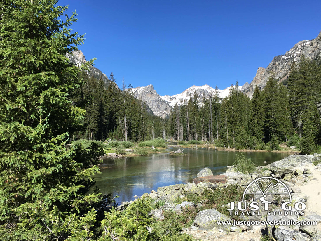
Amy BrahanGrand Teton National Park is known for its majestic mountains, pristine lakes and plentiful wildlife. You can take beautiful photos from any of the viewpoints; but, the best way to experience the park is to go hiking! Grand Teton has 242 miles of hiking trails spread over 310,000 acres. Hiking is one of the most popular things to do in Grand Teton National Park and there are trails for all skill levels. If you only have a day or two to explore the park, you may not have time for a full day hike or a backpacking excursion. So, we’ve put together this list of what we think are 5 of the best day hikes in Grand Teton National Park.
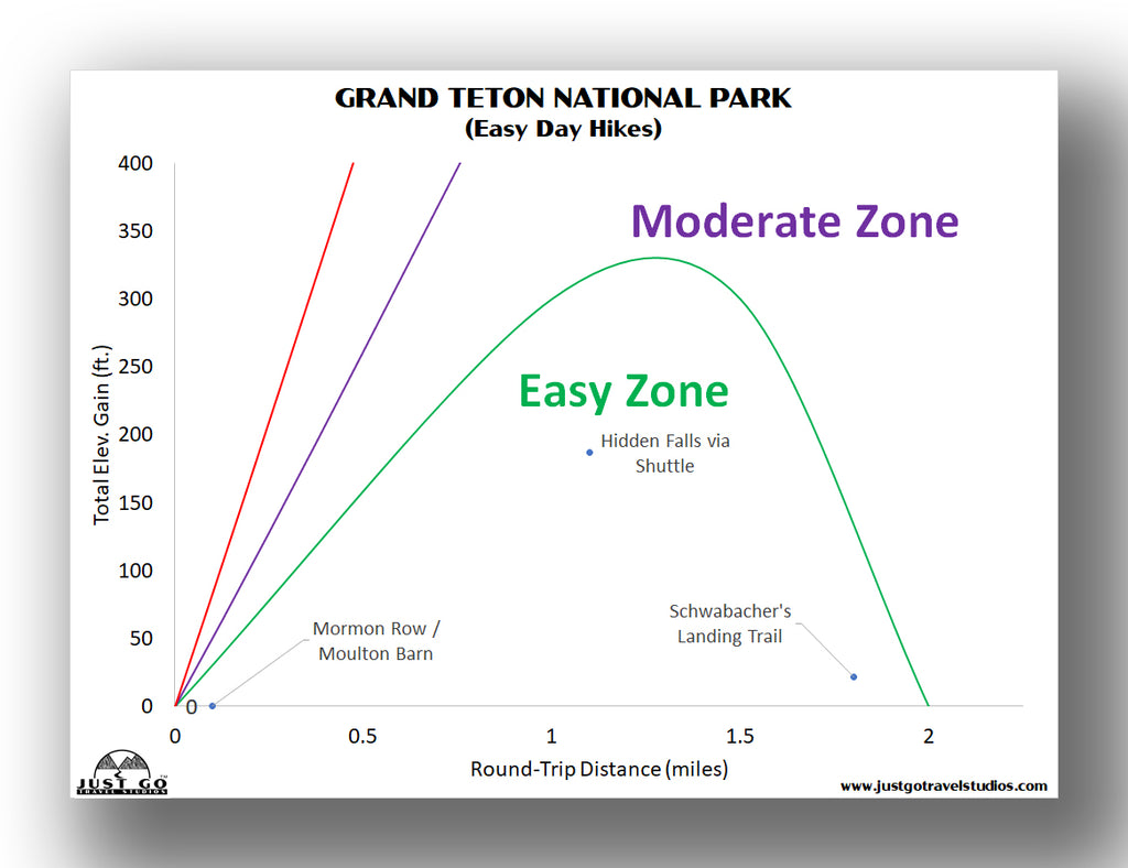
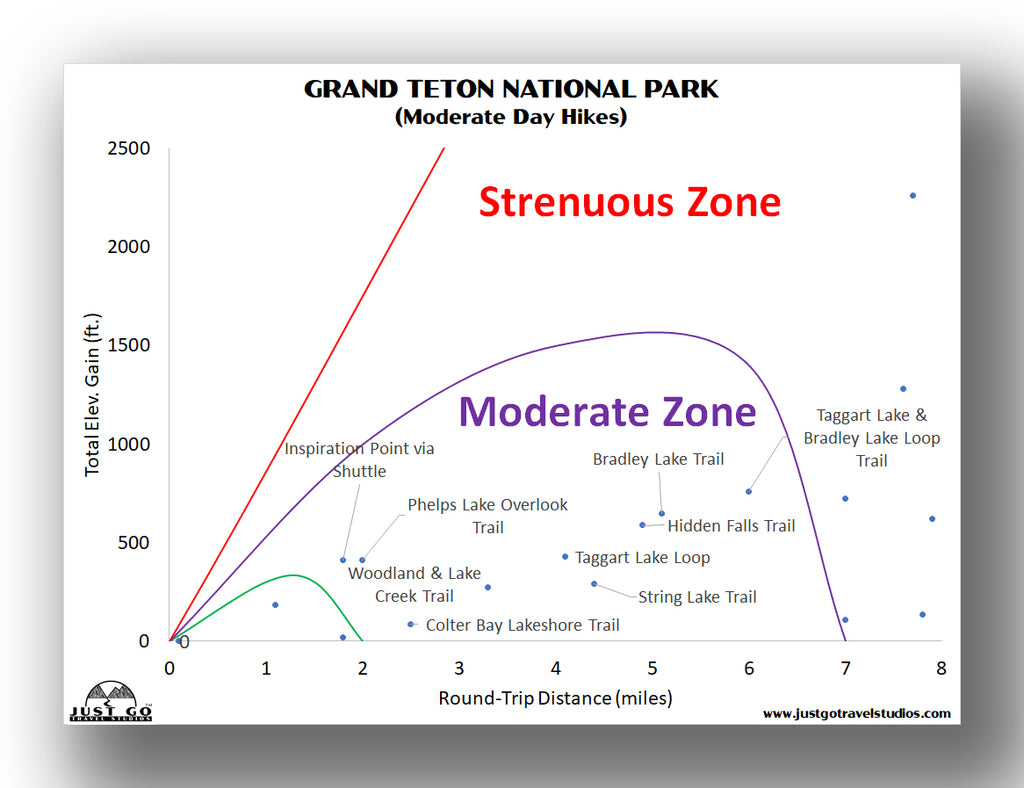
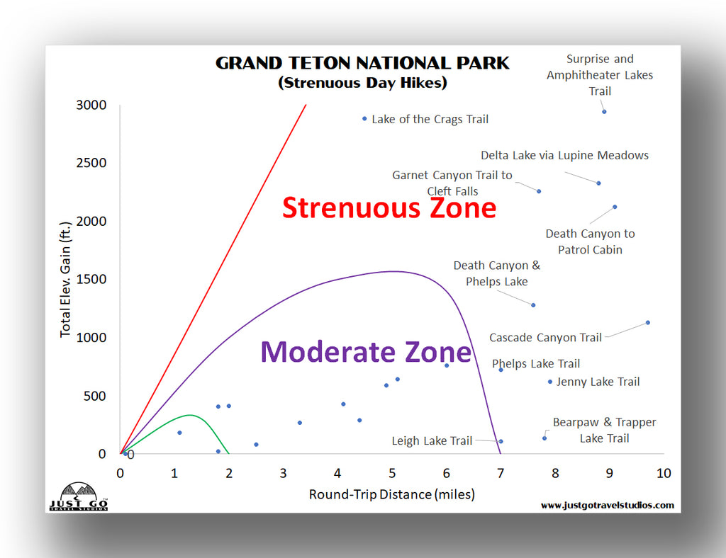
GRAND TETON NATIONAL PARK HIKING: DISTANCES AND ELEVATION GAIN
To help out in picking the right hike for you and your travel-mates, we put together a few charts to help make it easy to select what you are looking for.

See our itinerary for Grand Teton National Park for more information on suggested hiking trails.
BEST DAY HIKES IN GRAND TETON NATIONAL PARK: TRAIL DESCRIPTIONS AND TRAIL MAPS
TAGGART LAKE / TAGGART LAKE & BEAVER CREEK LOOP
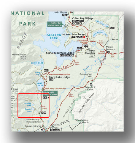
Taggart Lake was our very first hike in Wyoming, and it did not disappoint! We think it is one of the best easy day hikes in Grand Teton National Park. The 1.5-mile hike to Taggart Lake winds through beautiful aspen forest, open fields and mixed forest before reaching stunning Taggart Lake. However, what really stands out is that the Tetons remain visible along the entire route, making for a wonderful backdrop throughout the hike. Since the out-and-back hike (3-miles roundtrip) is relatively easy for families (minimal elevation gain with some hilly sections), it is one of the most popular hikes in the park. However, if you get an early start, you can still find a quiet spot by the lake to take in the views.


To depart from Taggart Lake, you can retrace your steps back to the parking area, which many people do. However, we recommend combining the Taggart Lake Trail with the Beaver Creek Trail for a 3.9-mile loop. The Beaver Creek Trail is far less-travelled than the Taggart Lake Trail and offers a change of scenery. It travels through glacial moraine, evergreen forest and grassy meadows before returning to the parking area. One advantage of heading back via the Beaver Creek Trail is the panoramic views to the east.

This loop could be hiked in the opposite direction, but we chose to hike the busiest part of the trail in the early morning and enjoy the Beaver Creek solitude on the tail end of our hike.
The Taggart Lake Trailhead is located west of Moose Junction after driving about 3.5 miles on Teton Park Road (when travelling from the Jackson). This is a great hike to do first thing in the morning due to its proximity to Jackson and its popularity.
Hike Option: The Taggart Lake/ Bradley Lake Loop (5.1-miles roundtrip) is a popular option for those looking for a longer hike.
HIDDEN FALLS AND INSPIRATION POINT (LOWER)

Cascade Canyon, Hidden Falls and Inspiration Point Map (courtesy of the National Park Service)
Hidden Falls is another popular trail in the park that climbs above Jenny Lake’s south shore and leads to a 200-foot cascade. There are a few different ways to reach the Hidden Falls trailhead on the west side of Jenny Lake. If you have plenty of time, hike all the way to Hidden Falls via the Jenny Lake Trail which travels around the south end of Jenny Lake. This moderate hike is 4.8-miles roundtrip and has about 1200 feet of elevation gain.

Another option is to take the Jenny Lake ferry across the lake to the West Shore Boat Dock and the Cascade Canyon Trailhead. This is the shortest and easiest route to Hidden Falls and involves a 1.2-mile roundtrip hike. The trail heads south from the landing before turning west and climbing along a rushing river. The short hike to Hidden Falls does have about 200 feet of elevation gain, but it offers plenty of shade and places to rest along the way.

At the trail’s end, watch as the falls drop about 200 feet and create an impressive spray that is refreshing on a hot day! Enjoy the newly completed Hidden Falls viewing area and have a snack before heading back to the boat landing.

However, if you’ve come this far, you might as well continue 0.3 miles uphill to the scenic Lower Inspiration Point overlooking Jenny Lake! The hike to Lower Inspiration Point via the shuttle boat, and including the side trip to Hidden Falls, is a moderate 1.8-mile roundtrip hike.

NOTE: The trail to the traditional Inspiration Point (originally 0.4 miles uphill from Hidden Falls) is undergoing trail rehabilitation and is currently closed. Be sure to check in at the visitor center for up-to-date information on trail closures and detours during Jenny Lake Renewal Project construction.
To access the trails to Hidden Lake and/or Lower Inspiration Point, park at the south end of Jenny Lake. The parking lot for the trailhead is shared with the lot for the Jenny Lake Visitor Center. While the lot is large, this popular area does fill up early in the day.
Jenny Lake Boating offers trips across the lake about every 10-15 minutes. The cost is around $15 for adults (round trip) and less for children under 12. When we visited, the first boat of the morning (7am) was $5 if paid in cash. We received this hint from another blogger. While there isn’t any reference to this offer on the Jenny Lake Boating website, it’s worth asking about the night before your visit. The advantage of taking the first Jenny Lake shuttle boat is that it allows you to get ahead of the crowds.
Hike Option: Another way to access Hidden Falls and Lower Inspiration Point is via the Jenny Lake Trail from String Lake (5.6-5.8 miles roundtrip). Park at the String Lake parking area to access the String Lake trailhead.
CASCADE CANYON TRAIL

Cascade Canyon Trail Map (courtesy of the National Park Service)
The Jenny Lake area offers several great trails, but the Cascade Canyon Trail was, by far, our favorite day hike in Grand Teton National Park. It is also frequently rated as the top trail in Grand Teton and one of the best trails in the US, so we assure you this is a trail not to be missed! This moderate to strenuous hike leads into spectacular Cascade Canyon with views of Grand Teton, Mount Owen and Teewinot Mountain. The hike to the Forks of Cascade Canyon is about 13.6-miles roundtrip with 1500 feet elevation gain (or about 9.6-miles roundtrip and 1220 feet elevation gain by taking the shuttle across the lake).

The first half-mile or so is fairly steep, but the trail flattens out beyond the switchbacks as it heads into the canyon. Although this trail is very popular, the steady stream of hikers tends to thin the further you hike. Many of the best views aren’t very far into the canyon, so you don’t need to hike all the way to the Forks to grasp the beauty of this glacial carved wonder. Along the way, the trail passes waterfalls, ponds, creeks, and craggy peaks in addition to offering the possibility of a moose or bear sighting.

Our family combined the hike with a side excursion to Hidden Falls and Inspiration Point (which was open at the time). To make sure the kids all head enough energy to get back, we only hiked part-way into the canyon before retracing our steps to the boat dock. I must admit…it was tough turning around!

To access the Cascade Canyon Trailhead, see directions for accessing Hidden Lake and Lower Inspiration Point. From the west side of Jenny Lake, the Cascade Canyon Trail can currently only be accessed via the horse trail bypass.
Hike Option: From the Forks, hikers can continue for another 2.7-miles up to Lake Solitude, a beautiful alpine lake (extension includes another 1200 feet of climbing).
STRING LAKE TRAIL

String Lake and Leigh Lake Map (courtesy of the National Park Service)
The easy String Lake Loop is a great introduction to Grand Teton National Park and is perfect for the whole family! This 3.7-mile hike travels around the perimeter of String Lake and offers amazing views of Cascade Canyon as you cross the bridge near the trailhead. Hike in the counter-clockwise direction for the best views of the mountains above String Lake in the early morning light. A morning hike also offers a good chance of spotting wildlife such as a moose or mule deer.

The String Lake Trailhead is located on the shores of String Lake, just north of Jenny Lake. Get here early to find a parking spot or hike late in the afternoon.
Hike Option: Continue your hike beyond the shores of String Lake to scenic Paintbrush Canyon. Near the half-way point of the loop, connect to the Paintbrush Canyon Trail for a full-day hike. A popular backpacking trip is to complete the Paintbrush and Cascade Canyon Loop (19 miles roundtrip).
LEIGH LAKE TRAIL
Leigh Lake is the third largest lake (behind Jackson Lake and Jenny Lake) in Grand Teton National Park. The hike to this lake yields sweeping views of the Grand Tetons and, if you get lucky, amazing reflections in the water on a calm day. The easy 1.8-mile out-and-back hike starts along the shores of String Lake. After passing a footbridge over a stream, the trail climbs about 40 feet and eventually meets up with the southern end of Leigh Lake.

The bridge between the two lakes is a great place to hang out if you want to relax with the water rushing beneath your feet.

Return the way you came or keep hiking along the shoreline of Leigh Lake. Hike as little as 1.8 miles (roundtrip) to reach the shores of Leigh Lake or as far as 7.6 miles (roundtrip) to reach the northern end of the lake and the Leigh Lake Ranger Patrol Cabin.
The String Lake Trailhead, which leads to the Leigh Lake Trailhead, is located on the shores of String Lake, just north of Jenny Lake. Get here early to find a parking spot since we hear this is a beautiful place to hike in the morning. The shallow shoreline of String Lake is popular spot for people to relax and play on a hot summer day, so this area tends to stay busy through the afternoon. However, we didn’t have trouble parking late in the afternoon.
Hike Option: Continue your hike beyond the forested shores of Leigh Lake to one of the neighboring smaller lakes, Bearpaw Lake or Trapper Lake, with views of Mount Moran. The hike to Bearpaw Lake is 7.8 miles RT and Trapper Lake is a moderate 9.2 miles RT.
MORE GREAT DAY HIKES IN GRAND TETON NATIONAL PARK
EASY DAY HIKES
- Colter Bay Lakeshore Trail: 2 miles RT with 100 feet elevation gain. Views of Jackson Lake and the Grand Tetons. Possible wildlife sightings. Trailhead at Colter Bay Village.
- Lunch Tree Trail: 0.5 mile RT with 104 feet elevation gain. Short interpretive trail leads to views of Willow Flats and the Teton Mountain Range. Possible wildlife sightings and wildflowers. Trailhead at Jackson Lake Lodge.
- Lake Creek to Woodland Trail: 3 miles RT with 300 feet elevation gain. Trail leads along the southeast shore of Phelps Lake. Trailhead is at Laurence S. Rockefeller Preserve.
MODERATE DAY HIKES
- Two Ocean Lake Trail: 6.1 miles RT with 462 feet elevation gain. Walk the trail counterclockwise for the best views of the Tetons. The Two Ocean Lake Trailhead is located just north of Pacific Creek Road (in the Jackson Lake area).
- Jenny Lake Loop: 7.1 miles RT with 900 feet elevation gain. This gently rolling trail skirts the shore of Jenny Lake. The Jenny Lake Trailhead is at South Jenny Lake Junction.
- Phelps Lake Loop: 7 miles RT with 725 feet elevation gain. First mile involves a bit of climbing before leveling out. Possible wildlife sightings. The trailhead is located off Moose Wilson Road at the Death Canyon Trailhead.
- Hermitage Point: 9.7 miles RT with 700 feet elevation gain. Gently rolling trail passes through forests, meadows and wetlands. Possible wildlife sightings. The Hermitage Point Trailhead is located at Colter Bay Village.
STRENUOUS (OR LONG) DAY HIKES
- Death Canyon Patrol Cabin: 7.9 miles RT with 2100 feet elevation gain. Steep trail climbs to overlook, drops toward Phelps Lake and then climbs through the canyon to a patrol cabin. Wildflowers, waterfalls and possible moose sightings along the way. The Death Canyon Trailhead is located off Moose-Wilson Road.
- Garnet Canyon: 8.4 miles RT with 2650 feet elevation gain. Steep climb into Garnet Canyon offers spectacular views of the Middle Teton. Access Garnet Canyon via the Lupine Meadows Trailhead.
- Amphitheater and Surprise Lakes: 10.1 miles RT with 3000 feet elevation gain. Steep hike to glacial lakes surrounded by meadows. Access both lakes via the Lupine Meadows Trailhead.
- Granite Canyon: 12.3 miles with 4200 feet total descent (with 450 feet of climbing). Take the Jacksole Hole Aerial Tram from Teton Village to the summit of Rendezvous Mountain. Hike into the park and down Granite Canyon. Return to Teton Village.
- Lake Solitude: 20 miles RT with 3900 feet elevation gain (via shuttle boat: 14.2 miles RT with 2420 feet elevation gain). Follow Cascade Canyon Trail past North Fork to Lake Solitude. Secluded alpine lake with mountain views and wildflowers.
See the National Park Service website for Grand Teton National Park hiking maps for specific trails in the park.
OTHER TIPS WHEN HIKING IN GRAND TETON NATIONAL PARK
- Grand Teton National Park is full of wildlife, with bears and moose roaming the mountains and forests. We highly recommend bringing bear spray and knowing how to use it. Don’t be afraid to make noise while you are hiking as well to avoid surprising any animal.
- Grand Teton National Park is a high elevation park. The thin air at high elevations can cause dizziness, nausea and shortness of breath. Even if you’re not climbing the high peaks, many of the hikes in the park begin above 6,800 feet. Even the elevation in Jackson Hole is 6,320 feet! Be sure to pace yourself if you aren’t used to hiking at high elevation. Take frequent breaks and stay hydrated while you are out exploring the park.
- Check the weather forecast before heading out and be prepared for sudden weather changes.
- Snow melt affects the condition of trails in the spring and early summer. Check with a ranger for up-to-date information on trail conditions and closures.
FURTHER INFORMATION ON GRAND TETON NATIONAL PARK FROM JUST GO TRAVEL STUDIOS
- All the hikes you see in this blog as well as many others are ranked and detailed in our downloadable itinerary for Grand Teton National Park.
- We have several other great resources on Grand Teton National Park, including Grand Teton National Park – What to See and Do and details on Cascade Canyon Trail (with Hidden Falls and Inspiration Point) Trail as well as an in-depth blog on Hiking the Taggart Lake Trail.
- We also cover what to make sure you bring in our blog Grand Teton – What to Pack.
- We also create custom, vintage-style posters, postcards and note cards from your travel photos. Check out our process!

ADDITIONAL USEFUL INFORMATION ON GRAND TETON NATIONAL PARK AND THE SURROUNDING AREA
- The National Park Service has an excellent website on Grand Teton National Park. It is a wealth of information. Be advised, though, that cell service in the park is very limited, so make sure you do your planning ahead and get all you need before you leave!
- Are you thinking about making Jackson Hole your base and heading out on day trips? Charles and Micki (from “The Barefoot Nomad”) provide a few great ideas on Day Trips from Jackson Hole.
- The Flatcreek Inn in Jackson Hole, Wyoming has a great list of 101 Fun things to do in Jackson Hole. Make sure you check it out if you are looking for a few more ideas!

