Pinnacles National Park: Things to Do, Hiking Trails, Camping, Maps & More
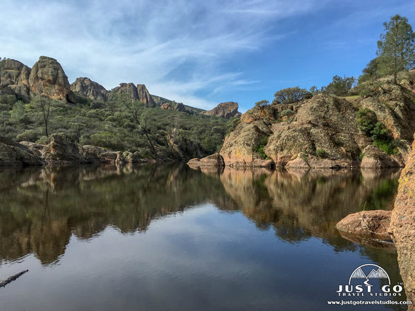
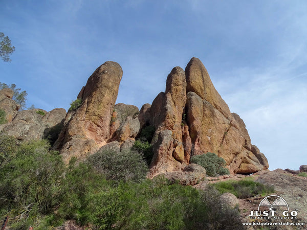
Peter BrahanBorn of erosion from a volcano on the San Andreas fault, Pinnacles National Park is an imposing rock formation in California. The high peaks of the park rise over 3,000 feet from the surrounding landscape in a way that could only happen through thousands of years of tectonic movement.
What was created from movement along the San Andreas Fault attracts hikers and rock climbers from all over the world.
This northern California park (which is just south of San Jose) has long been set aside as a protected land. In fact, President Theodore Roosevelt established Pinnacles National Monument in 1908. It took 104 years before it became a national park in 2012, and is therefore one of the newest national parks in the country.
With just over 26,000 acres, Pinnacles National Park is one of the smaller parks in the country. And even though Pinnacles is just 90 minutes from millions of people living in the greater San Francisco and San Jose area, it only attracts just over a quarter million visitors a year.
While we certainly liked having the park nearly to ourselves during a visit in the winter, we think we need to spread the word about this great park. We know that whoever comes here will love it as much as we did!
Do yourself a favor-if you are heading to the San Francisco area, make sure you stop in at Pinnacles National Park for a day or so. You won’t be disappointed!
Here are some tips on what you can expect to see in Pinnacles National Park.
What to see and do in Pinnacles National Park, including maps, information on camping, what to pack and the best hikes (in ranked order), is all included in our itinerary for Pinnacles National Park. This downloadable guide will help you kick start your planning and is a nice companion document to this article.
PINNACLES NATIONAL PARK – EAST OR WEST ENTRANCE?
There are two distinct halves of Pinnacles National Park: the east and west sides. The only way to get from one side to the other by car is to drive out of the park limits. This trip will take over an hour. The other option is to hike through the high peaks, which is possible on several trails.
The east side of the park is more popular than the west side due to the presence of the visitor center, camping and a wider selection of trailheads. However, both sides of the park are worth visiting as they offer a different perspective of the high peaks. If you only have time to visit one, we recommend the east side.
PINNACLES NATIONAL PARK EAST ENTRANCE

Map of the Pinnacles National Park East Entrance area, courtesy of the National Park Service
The East Entrance of Pinnacles National Park is reached by heading south on Highway 25 from Paicines, CA. The drive down from Paicines was surprising to us. After being in the large cities that the Bay Area is known for, the drive on Highway 25 was quiet and very enjoyable. Since we targeted a 7:30 AM arrival to the park, there weren’t any other cars on the road to speak of, so we all enjoyed looking at the farms and green landscape without having to worry much about long lines of traffic.
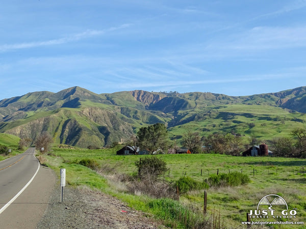
The drive down isn’t as peaceful for many, though, as the park can get quite busy during certain times of year. Lines of cars to the entrance gate between 10 am and 2 pm are very normal, so arrive early if you want to get into the park and spend your day visiting the park rather than waiting in line.
When visiting Pinnacles National Park from the East Entrance, our recommendations include:
- Pinnacles National Park Visitor Center. While we haven’t been to all parks in the United States, we’ve been to a lot. We can tell you that the Pinnacles visitor center is one of the smaller ones we’ve seen. However, don’t let that stop you from visiting. The visitor center has a few exhibits, a small gift shop and camping supplies. The best part, though, is the access to very knowledgeable and friendly park rangers. Since internet service around here is non-existent, this is the last official resource that can give you the latest information on what hikes to take, the status of the caves and answer any other questions you may have.
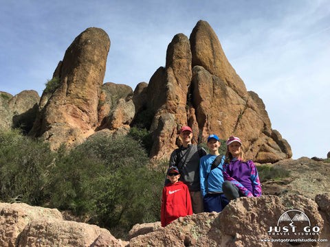
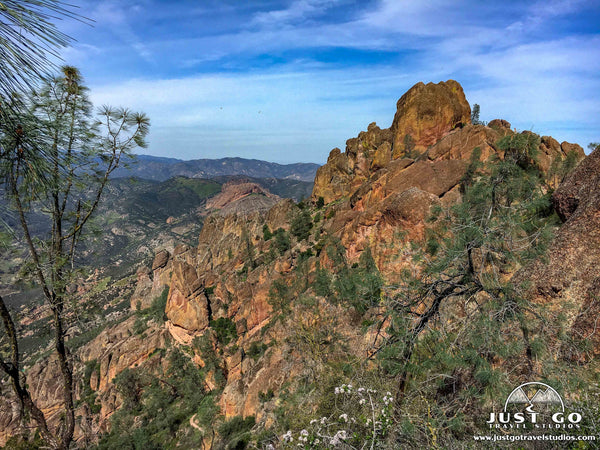
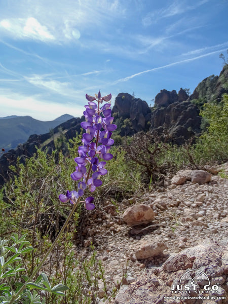
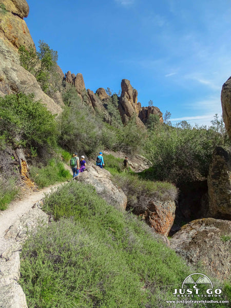
- Hiking. Most of the hiking in Pinnacles National Park centers around the high peaks in the center of the park. Additionally, many of the trails are rated as moderate or difficult due to the sheer elevation gain. These hikes are made even more challenging by the hot and dry air that California is known for. Don’t let this stop you, though! If you have the will, scaling the high peaks is more than doable (even for children who are motivated by candy, like ours!). We recommend the following trails:
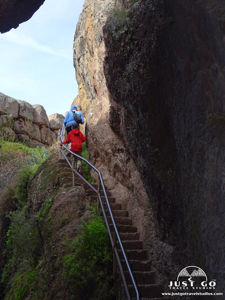
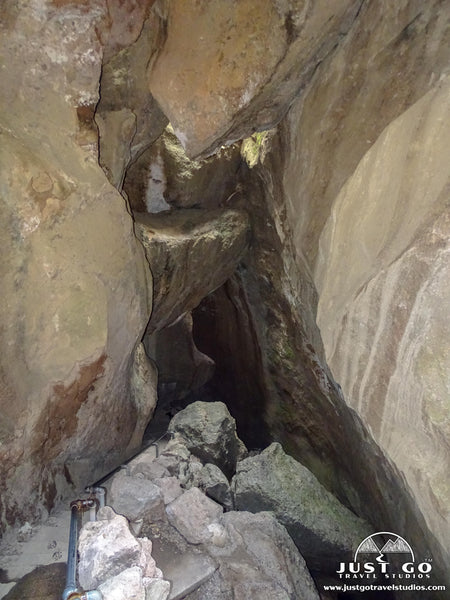
- The Condor Gulch Trail to the High Peaks Trail Loop is a spectacular trail and one of the most popular among those who are up for the task. This is a difficult 6.2-mile hike that makes a loop to the high peaks and gains over 1,600 feet in elevation. From up here, you can get up close (at least as close as you can get) to the resident California Condors. The trailhead starts from the Bear Gulch Day Use Area. After climbing continuously for two miles, the trail flattens out at the top where there is a restroom and plenty of space to take a break with the other hearty hikers. On the way down, the trail passes through Bear Gulch Cave (or around it if the cave is close due to bat mating). This is a hard hike, but well worth the effort! It’s no wonder why this made the list for being one of the best hikes in California!

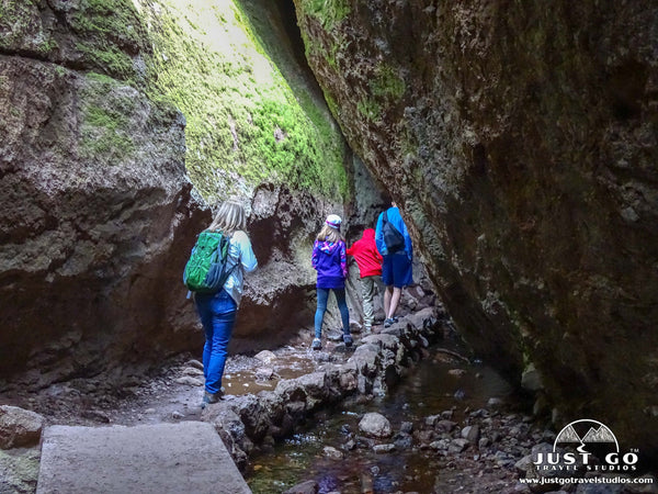
- The Bear Gulch Trail to the Reservoir via the Rim Trail is a 1.8-mile round trip that climbs 442 feet. This moderately challenging trail starts at the Bear Gulch Day Use Area. The trail passes through the Bear Gulch Cave, which can be dark. Make sure you have a flashlight or a headlamp to make your way safely through the cave, which involves a bit of climbing at the end. Though some of our family gets nervous in small, dark places, we all were able to do well on the short traverse through the cave and were glad we did it. Ahead of your visit, make sure to pick up a headlamp that is up for the task!
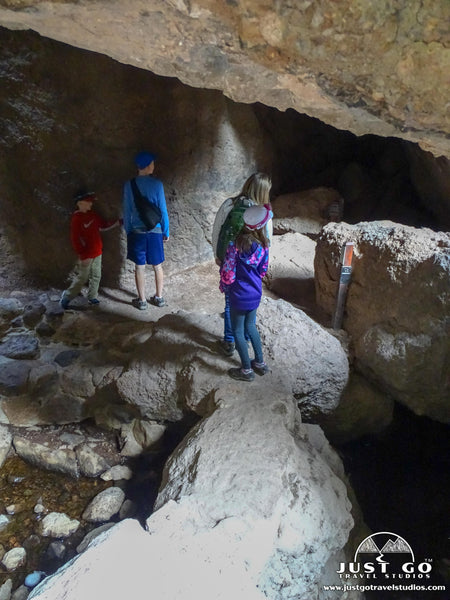
- The Old Pinnacles Trail to Balconies Cave is a moderate, 5.1-mile round trip that climbs nearly 500 feet. Starting at the Old Pinnacles Trail parking area, the trail is fairly flat before increasing in incline as it approaches Balconies Cave. After exploring the cave, the trail exits and creates a loop around the cave area before rejoining with the Old Pinnacles Trail.
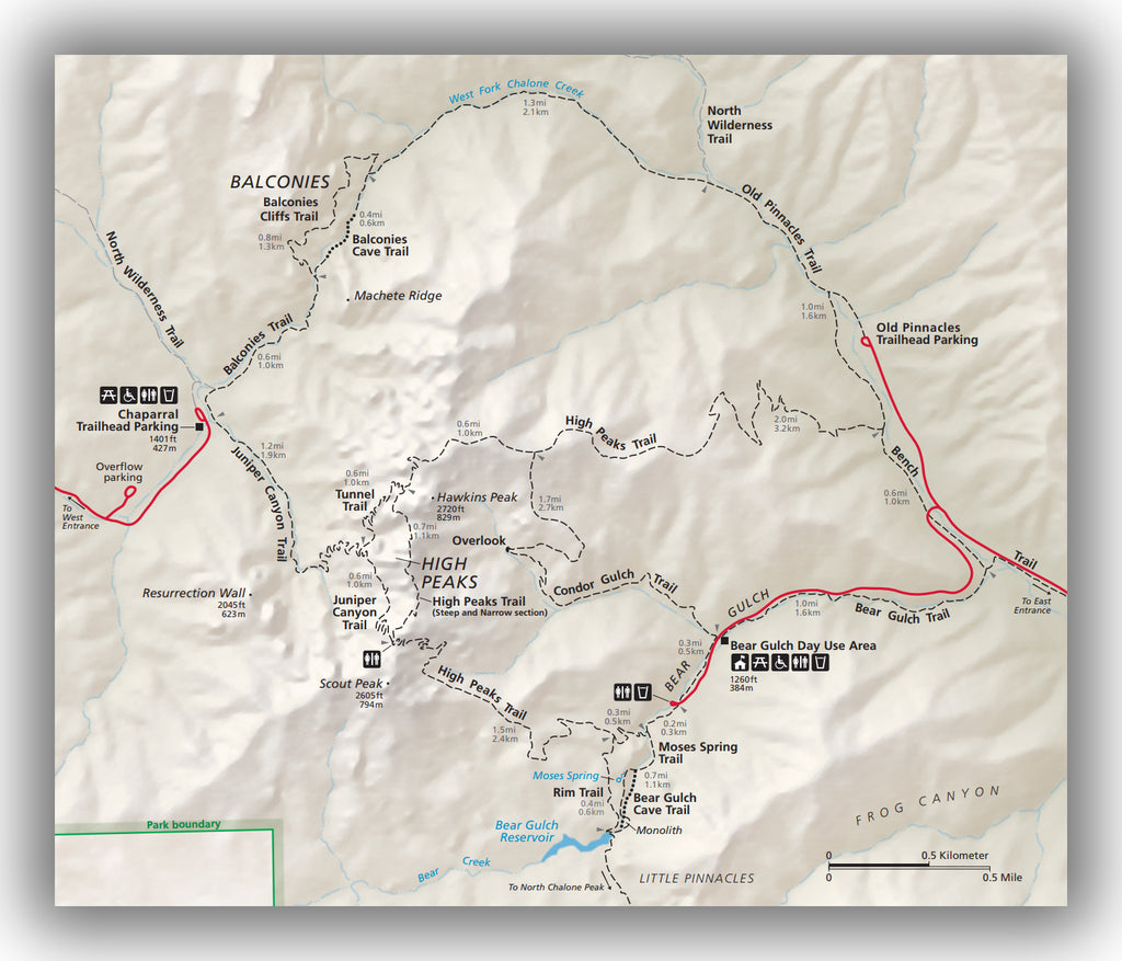
Map of the Pinnacles National Park High Peaks area, courtesy of the National Park Service
PINNACLES NATIONAL PARK WEST ENTRANCE

Map of the Pinnacles National Park West Entrance area, courtesy of the National Park Service
The West Entrance of Pinnacles National Park is reached by driving east from Soledad, CA on Highway 146. Soledad is a straight shot to the south on highway 101 from Salinas, CA.
When visiting Pinnacles National Park from the West Entrance, our recommendations mainly center around hiking:
- Hiking. The west side of Pinnacles National Park is at a higher elevation than the east side, making the elevation gain to the high peaks a little easier. The downside is that unlike the east side of the park, the west side only has one main trailhead. We recommend the following trails:
- The Juniper Canyon and High Peaks Loop Trail is a challenging 3.6-mile (round trip) hike to the high peaks. The trail starts from the Chaparral Trailhead parking area. Climbing nearly 1,300 feet in elevation, this is the most direct route to the peaks. Make sure you hike in the counterclockwise direction, as it is much safer to navigate the peaks this way rather than hiking clockwise.
- The Balconies Trail to the Balconies Cave is a 2.5-mile round trip hike that is moderately difficult. Starting at the Chaparral Trailhead parking area, the trail climbs just over 400 feet on the way up to the Balconies Cave. Be sure to bring a headlamp to this cave as well! They are dark, but really amazing to explore.
WHERE TO STAY IN AND AROUND PINNACLES NATIONAL PARK
- Pinnacles National Park Lodging: There is no lodging inside of Pinnacles National Park.
- Lodging near Pinnacles National Park: Morgan Hill, CA has the most options and is north of park. Other hotels near Pinnacles National Park can be found in Salinas, CA, or you can stay in Monterey (though Monterey is about 90 minutes from Pinnacles, so you’ll have to get up early to beat the crowds).If you are looking to stay in one location and have good access to both parts of the park, then King City, CA is also a good option.
- Pinnacles National Park Camping: There is one campground inside of Pinnacles National Park and it is located near the east entrance. Reservations can be made ahead of time and are recommended.
Most people only spend part of a day inside of Pinnacles National Park. If you are planning on getting here early, that is plenty of time for you to enjoy at least one long hike and explore some of the caves.
HOW TO GET TO PINNACLES NATIONAL PARK
The closest major airport to Pinnacles National Park is in San Jose, CA, which is serviced by several major carriers. San Francisco is slightly further away but is also an outstanding option to consider.
Basic directions to Pinnacles National Park can be found here:
- Directions from San Jose to Pinnacles National Park (76 miles)
- Directions from San Francisco to Pinnacles National Park (128 miles)
- Directions from Monterey to Pinnacles National Park (53 miles)
WHAT TO BRING TO PINNACLES NATIONAL PARK
Pinnacles National Park has no nearby grocery stores or outfitters, so make sure you have what you need ahead of your visit. Here are a few items that we recommend:
- If you plan on doing any hiking, then make sure you have a good hiking first-aid kit with you. The rock here is pretty rough, so if you fall you are likely to get scraped up. Also, if you head into the caves, it’s easy to slip here as well.
- Speaking of caves, if you do go in make sure you have a great headlamp. While not necessary, it can certainly help making it a more enjoyable experience if you can see where you are going!
- We were surprised at how much sun there was here, even in the late winter. It’s easy to get a sunburn, so be sure to bring a hat, glasses and sun protection.
- Finally, binoculars will come in handy. We were lucky enough to see the condors on our own without magnification, but that is rare!
PINNACLES NATIONAL PARK WEATHER AND SEASONAL CONSIDERATIONS
Weather in Pinnacles National Park is dry most of the year and the temperatures range from highs in the 80’s in summer to highs in the 60’s in winter. Summertime is very hot and dry here, and since most of the trails are exposed, you need to make sure you bring plenty of protection from the sun and water.
Winter and early spring are the most popular times to visit the park, with the peak visitation happening in March and April.
The Bear Gulch Cave and Balconies Cave are closed during certain times of year due to bats coming to give birth to their young. While nothing seems more enjoyable than being in a dark cave with protective mother bats and thousands of baby bats, it’s probably best that the park shuts down the cave during this time to keep the wildlife undisturbed.
FURTHER INFORMATION ON PINNACLES NATIONAL PARK AND THE SURROUNDING AREA FROM JUST GO TRAVEL STUDIOS
- Ahead of your trip make sure you download our itinerary for Pinnacles National Park.
- The entire Bay Area of California has a ton to offer. We also loved our visits to the Marin Headlands and our hike on the Point Bonita Lighthouse Trail as well as the visit to Muir Woods National Monument. Check out our blog posts to read more.
- Pinnacles National Park can be a great diversion while traveling along California’s Highway 1. To learn more about PCH, check out our blog on Driving Highway 1 between Los Angeles and San Francisco.
- When you return from your trip, be sure to send us a photo so that we can create on of our unique, custom, vintage-style travel posters. We’ve created thousands and are sure you will be pleased with the results. In the event that you have close up photos of bats, just make sure you give us a heads up ahead of time before we open the photo on our computer!