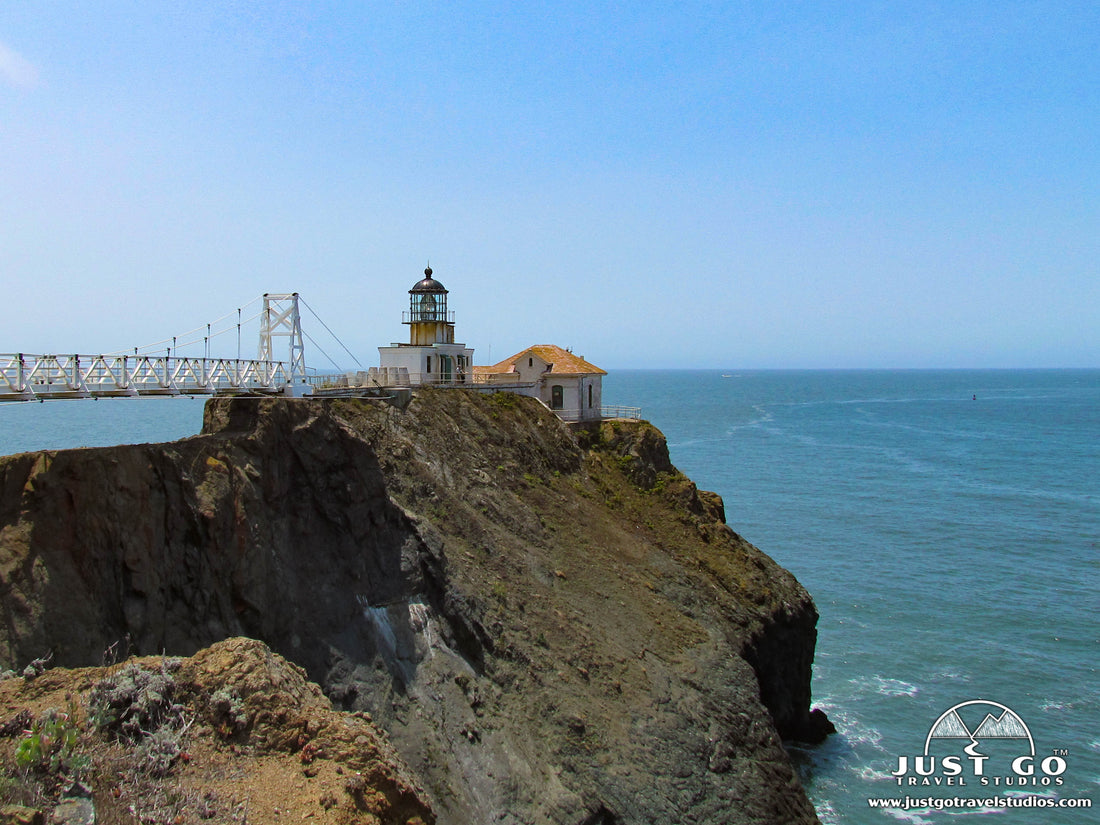
Point Bonita Lighthouse in Marin Headlands
Peter BrahanOf all the “must-do” activities in the Marin Headlands, the Point Bonita Lighthouse hike is an excellent choice while you are visiting this part of the Golden Gate National Recreation Area. The highlight of this short trail is heading across the suspension bridge that leads to the Point Bonita Lighthouse, but the entire trip has great views, including views of the Golden Gate Bridge and the San Francisco Bay.
While the weather in this part of the bay may tend to get foggy frequently, if you are able to see the Marin Headlands on a clear day (or at least a clear part of the day) you are in for a real treat!
POINT BONITA LIGHTHOUSE TRAIL DETAILS
- Difficulty: Easy
- Distance: 1.0 mile (round-trip)
- Trail: Out-and-back
- Elevation gain: 170 feet
- Peak elevation reached: 209 feet
- Best time of year to hike: Year-round
- To beat the crowds: Arrive before 12:00 pm or after 3:30 pm
- Footwear: Sneakers
- Watch out for: Sun exposure
- Restrooms: At the trailhead, but none on the trail
- Pets: Not allowed
- Time needed: 30-60 minutes
The Point Bonita Lighthouse is one of many places to visit in the area and we have it any other favorites pointed out in our guide on Muir Woods National Monument (with Marin Headlands). Our goal is to help you take the guesswork out of your planning with our downloadable itineraries!
PARKING AND TRAILHEAD FOR THE POINT BONITA LIGHTHOUSE HIKE

The Point Bonita Lighthouse Trail is located at the Point Bonita Lighthouse Parking Area at the end of Field Road in Marin Headlands.
- Directions from Marin Headlands Visitor Center to the Point Bonita Lighthouse Trail (this will take about 3 minutes).
- Directions from Sausalito, CA to the Point Bonita Lighthouse Trail (this will take about 20 minutes, or 30 minutes on a heavy traffic day).
The parking area for the trail is small, but since the trail is so short, the turnover for parking is quite high. If you are patient you will be able to find a spot within five to ten minutes.
Restrooms are located on the Field Road cul-de-sac and no restrooms on the trail.
THE POINT BONITA LIGHTHOUSE HIKE
From the parking area, the hike starts to descend quickly. In fact, the packed gravel trail is fairly steep, and most of the 80-foot descent happens in the first half of the hike. On the way to the lighthouse this isn’t really an issue. In fact, we saw plenty of kids running down the trail. If you are not used to hiking frequently, though, keep a close eye on the trail conditions to make sure you can make it back up without issue. When we visited, we saw a ton of visitors having to rest several times on the way back up.
About 0.25 miles into the trail, the path comes to a hand-carved tunnel. This tunnel is 118 feet long, and they didn’t dig much extra than was absolutely needed for supplies and people into (in other words, the tunnel is fairly small, at about six feet tall and four feet wide). Don’t worry, you won’t feel at all claustrophobic-even us tall hikers are able to squeeze through just fine. If you get a chance to view the trail from the air (using online maps), the tunnel is especially impressive, given the fact that it is right on a hillside.

After the tunnel, the trail crosses a small bridge before arriving at the landing area just before the suspension bridge. The suspension bridge crosses a span of 156 feet and stands 124 feet above the water. It really is quite an impressive feature of this trail-it's not very common to see a suspension bridge like this on a hike, and not one this far above the water!


The suspension bridge and Point Bonita Lighthouse hours are from 12:30 pm to 3:30 pm on Sundays and Mondays, as access to both are manned by volunteers. Since the number of people that can be in the lighthouse at any one time is limited, the line to enter the lighthouse can form and take quite a bit of time. If you are patient enough, the hike across the bridge is actually really quite cool. When we went, we had to wait about 10 minutes to gain access to the bridge and the lighthouse.
While here you will have to check out the harbor seals below. There are a ton of them, and they make quite the noise that you can hear in between wave crashes.

If the area is not fogged in, expect to see terrific views of the Golden Gate Bridge and the San Francisco City skyline.

The hike back will take you a bit longer, as you’ll have to climb up another 110 feet in elevation (170 feet total climbing after the ups and downs). The entire hike is only about 1.0 mile, so if you are in a hurry you will be able to do this fairly rapidly.
HISTORY OF THE POINT BONITA LIGHTHOUSE
The Point Bonita Lighthouse was placed in this location in 1877 to help vessels safely enter and exit San Francisco Bay. The lighthouse has undergone a few changes since then, but the most significant changes have been to the access to the lighthouse.

Originally accessed by a land bridge, erosion removed the land that connected to the lighthouse in 1940. This was quickly replaced by a wooden bridge, which became too precarious. Finally in 1954 the wooden bridge was replaced by a suspension bridge. This suspension bridge had remained in place since 1954 and undergone several renovations before being completely rebuilt in 2012 (by the Flatiron Corporation), including the most recent one in 2012.
Additional details on the lighthouse, including the history of shipwrecks, can be found on the National Park Point Bonita Lighthouse downloadable .pdf.
FINAL THOUGHTS
- The Marin Headlands is a great place to visit, and a bit of an island of nature in an otherwise crowded and built-up San Francisco metropolitan area. We highly recommend making an effort to visit this area as you can easily spend an afternoon (or more) exploring all the sights.
- Another interesting attraction on the Marin Headlands that is only open on Saturdays is the Nike Missile site. You can check out a piece of cold war history here, and find more information on the National Park Service Nike Missile Site information page.
- While the risk of injury on this trail is low, you should be aware that there are significant drop-offs on the trail. Keep a close eye on your kids, as once every ten years or so, someone falls to their death.
FURTHER INFORMATION ON MARIN HEADLANDS AND THE SURROUNDING AREA FROM JUST GO TRAVEL STUDIOS
- Be sure to check out our downloadable itinerary for Muir Woods National Monument and the Marin Headlands. We cover the best hikes and tips on what to see and do while you are visiting the area.
- Check out how we spent our day when visiting Muir Woods in our blog, Just Go to Muir Woods – A Morning of Hiking and Exploring.
- About two hours to the south is one of the newest National Park sites in the country. Be sure to check out our blog post on What to See and Do in Pinnacles National Park to learn more.
- Once you get back from your trip, look us up and we’ll work with you to take a photo that you send us and create a vintage-style travel poster. You really won’t believe what we can do with your photos-we love to do it, and can’t wait to partner with you on a very special vacation memory!

ADDITIONAL INFORMATION ON MARIN HEADLANDS AND THE SURROUNDING AREA
- There is a ton of information about San Francisco, but one of the best blogs we’ve seen is from Jenna (from “This is my Happiness”). Be sure to check out her write up, Build a Perfect Day Trip to San Francisco. We guarantee she has ideas that you’ll find useful as you plan your trip to the area!
- Paulina (from “Little Grunts”) has a great blog on exploring the Point Reyes Lighthouse, which is about an hour to the north of Marin Headlands.

