
11 Best Hikes in Canyonlands National Park: Trail Maps, Directions & More
Peter BrahanTrying to pick the best hikes in Canyonlands National Park can be challenging. This park, located near Arches National Park and Dead Horse Point State Park, has a lot of great hikes to choose from for hikers of all capabilities. The great thing is that even though there are so many trails, you really can’t go wrong with whichever hikes you pick to spend your time on.
Both the Needles District (to the south) and the Island in the Sky District (to the north) offer good hiking opportunities.
Though there are several dozen hikes in Canyonlands National Park, we did our best to narrow them down to the best-let us know how we did by leaving a comment!
CANYONLANDS NATIONAL PARK HIKING: DISTANCES AND ELEVATION GAIN
As with most National Parks, you won’t be struggling to find things to do in Canyonlands National Park. The hard part is to find out exactly how you will spend your precious time, as it’s hard to find people who don’t come away from this park wishing they had more time to spend exploring it.
You may be surprised to see that there are so many hikes in this park-many more than its neighboring Arches National Park, and many of them are a bit more challenging than those you find in Arches. To help you out, we put together these graphs that should help you select your hike.
If you are looking for an easy trail, there are several to choose from in the chart below:

Those looking for more moderate or even on the low side of strenuous hikes can explore one of these trails:

Of course, if you have the time and want to challenge yourself a bit more, these strenuous hikes are all good to choose from.

We’ll go into more detail in the article ahead, but hopefully this gets you a start at figuring out what hike is going to be best for you and your individual situation!

These hikes and more are included in our downloadable Canyonlands National Park Itinerary. The hikes are ranked in order of popularity. We include the elevation gain, location and difficulty as well. We also tell you what to pack, where to stay and what to do while you are in the area. Finally, we also include park maps. Download ahead of your trip to take the guesswork out of planning!

Island in the Sky map, courtesy of the National Park Service
BEST HIKES IN CANYONLANDS NATIONAL PARK: TRAIL DESCRIPTIONS AND TRAIL MAPS
MESA ARCH TRAIL
- Difficulty: Easy
- Distance (round-trip): 0.6 miles
- Elevation gain: 610 feet
- Hiking time (approximate): 30 minutes

Mesa Arch Trail map, courtesy of the National Park Service
If you are looking for an iconic hike in Canyonlands National Park, a big reward and little effort, then the Mesa Arch Trail is for you. It’s no wonder why this is one of the most popular hikes in Canyonlands. This trail (which is rated with a difficulty of “easy”) is one that you have to do if you head to the Island in the Sky District. The hike climbs just 121 feet in elevation (total) and has a round-trip distance of 0.6 miles. With photos, this trail shouldn’t take more than 30 minutes.
After walking through an easy trail (with a small amount of climbing), the hike ends with the most photographed arch in Canyonlands. At the end of the hike and just feet behind the arch is a sheer sandstone cliff, so keep an eye on any children.
The view is amazing at sunrise, in particular. Expect to find plenty of people on this hike, so get there earlier in the morning if you want a quieter experience. This hike and view are highly recommended.
The trail is fully exposed, so if you go in the summer (like we did), expect to be hot!
The trailhead starts at the Mesa Arch Parking area, which is 6.1 miles south of the Island in the Sky Visitor Center.

GRAND VIEW POINT TRAIL
- Difficulty: Easy
- Distance (round-trip): 1.8 miles
- Elevation gain: 200 feet
- Hiking time (approximate): 1 hour

Grand View Point Trail map, courtesy of the National Park Service
The Grand View Point trail in the Island in the Sky District is a very popular trail as it has great views along the entire route. This easy trail is mostly flat but has a total elevation gain of around 200 feet if you are adventurous at the end of the trail. The total round-trip distance is 1.8 miles. However, if you are just up for hiking part of the trail, the views will be nothing short of impressive. In fact, some of the views on this trail were more impressive and expansive than our experience in Grand Canyon National Park.
The trail heads to the southwest from the parking lot along a narrow ridge (with drop offs of around 1000 feet to either side of the trail). The most unique aspect of this rail is that there are views both to the west and east, with a nice 360-degree view at the end of the hike. Pictures don’t do this hike justice, since you really have to be there to see the landscape.
This hike really is something that everyone should try to experience if possible, as it is commonly rated as one of the best hiking trails in Canyonlands National Park.
The trailhead starts at the end of Grand View Point Road, approximately 12 miles south of the Island in the Sky Visitor Center.

FALSE KIVA TRAIL
- Difficulty: Easy / Moderate
- Distance (round-trip): 1.9 miles
- Elevation gain: 436 feet
- Hiking time (approximate): 1 to 1.5 hours

False Kiva Trail map, courtesy of the National Park Service
One of the more challenging hikes on this list is the False Kiva Trail. This hike is not well marked but is an official trail in Canyonlands. This 1.9-mile (round-trip) hike climbs a total of 436 feet in elevation and includes some rock scrambling near the end.
The trail descends first for about 400 feet before the final climb which is guided by Cairns (small rockpiles).
At the end of the trail is a man-made rock circle inside a perfect alcove, but unfortunately the alcove is no longer accessible due to vandalism. This hike is wonderful at sunset in particular, as the views from the alcove are absolutely breathtaking and provide for some great photos. If you do watch the sunset, make sure you take headlamps to help you find your way back.
The trailhead starts about 3.4 miles west of the intersection with Grand Road and Upheaval Dome Road, just south of the Alcove Springs Parking lot on the opposite side of the road and just south of the Alcove Springs Parking lot in the Island in the Sky District.

False Kiva Trail photo provided by John Buie
UPHEAVAL DOME TRAIL
- Difficulty: Easy / Moderate
- Distance (round-trip): 0.6 miles
- Elevation gain: 305 feet
- Hiking time (approximate): 1 to 1.5 hours

Upheaval Dome Trail map, courtesy of the National Park Service
Rounding out the best hikes in the Island in the Sky District is the Upheaval Dome Trail. This trail leads to an unusual one-mile wide crater. This trail has a moderate level of difficulty, made challenging only because of the uneven trail that climbs 305 feet total over the 1.6-mile (round-trip) hike.
The trail climbs up slowly to a view of a crater. Nobody quite knows how this crater was formed. The only thing certain is that it wasn’t created from erosion, like the rest of the features in the park.
If you want to cut the hike short, stop at the first overlook which is only 0.8 miles round-trip. The second overlook provides not only a view of the crater but also a few of the western side of Canyonlands National Park.
The trailhead starts at the end of the Upheaval Dome Road, 5 miles west of the junction with Grand View Point Road in the Island in the Sky District.


Needles District map, courtesy of the National Park Service
DRUID ARCH TRAIL
- Difficulty: Hard
- Distance (round-trip): 10.4 miles
- Elevation gain: 1633 feet
- Hiking time (approximate): 6 to 7 hours

Druid Arch Trail map, courtesy of the National Park Service
As one of the most challenging day-hikes in Canyonlands National Park, the Druid Arch Trail is a fantastic hike if you are up for work. This hike includes a significant amount of elevation gain (1633 feet) over the 10.4-mile (round-trip) hike.
The trail starts on the Chelser Park Trail, which has great scenery by itself before turning into the Druid Arch Trail. This trail leads to one of the most amazing views in the park. After climbing a few hundred feet for the first two miles, the trail descends sharply into a sandy wash before heading back uphill slowly.
The incline gets gradually steeper before having to navigate a ladder near the end (where the arch is located). The climb requires hikers to be nimble, but it is definitely doable (plus, you have the extra motivation of almost being at the end!). The arch is 450 feet high and is in a canyon that is also quite beautiful. Be advised that this trail also involves some deep sand, so make sure you have good shoes and bring plenty of water.
The trailhead starts at Elephant Hill, 6.3 miles west of the Needles District Visitor Center.

Druid Arch photo provided by Richie B pics
CAVE SPRING TRAIL
- Difficulty: Easy / Moderate
- Distance (round-trip): 0.6 miles
- Elevation gain: 29 feet
- Hiking time (approximate): 30 minutes

Cave Spring Trail map, courtesy of the National Park Service
The Cave Spring Trail is one of the shorter hikes in Canyonlands, but it is a good trail to do after one of the longer hikes in the park. While it is only 0.6 miles, the main attraction requires two ladder climbs for a total of 29 feet in elevation gain.
The hike is short and shaded (which is a rarity in Canyonlands National Park). This hike includes a camp with cowboy artifacts and petroglyphs. The views are nice as well as the much welcome shade!
The trailhead starts at the Cave Spring Trailhead, directly south of the Needles District entrance. Getting to the trail requires driving on a 1-mile dirt road, which is easily passable.

Cave Spring photo provided by John Fowler
SQUAW FLAT LOOP TRAIL
- Difficulty: Moderate / Hard
- Distance (round-trip): 7.2 miles
- Elevation gain: 620 feet
- Hiking time (approximate): 4 hours

The Squaw Flat Loop Trail is one of the longer hikes in Canyonlands National Park, but it is not overly difficult. Many break up the hike into two days, as there are campgrounds that are accessible on the hike. You can also use this hike as a jumping off trail to other hikes, such as going to Druid Arch.
Hiking counterclockwise, this trail first heads through sagebrush and Big Canyon (with views of Squaw Butte and the La Sal Mountains) before returning through Squaw Canyon. The trail is fairly flat for the most part, with the exception of a steeper uphill section about halfway through. The total elevation gain is about 620 feet.
Though this hike is a bit long, it is the most accessible hike in the Needles District that actually puts you right inside the landscape of the Needles District. If you do this hike, take your time and enjoy the journey. You won’t find any grand sweeping views, but what you will find is an immersive experience along your entire hike.
The trailhead starts at the Squaw Flat Parking area, about 4 miles from the Needles District Visitor Center.
AZTEC BUTTE TRAIL
- Difficulty: Easy
- Distance (round-trip): 1.6 miles
- Elevation gain: 260 feet
- Hiking time (approximate): 1 hour

Aztec Butte Trail map, courtesy of the National Park Service
The Aztec Butte Trail is short, and a wonderful way to see some amazing views of the canyon without too much work.
After starting off in the sand, the trail climbs steeply up a slickrock. There is a total of 260 feet of climbing on this hike and it happens over a short distance. While the trail and climbing are not particularly hard, you just need to make sure you watch your footing. It’s also not recommended to hike this trail after rained.
The views from the top are fantastic. Additionally, there are granary ruins about halfway through the hike.
The hike is 1.6 miles (round-trip) and should take under an hour.
The Aztec Butte Trail starts about 0.7 miles from the intersection with Grand View Road and Upheaval Dome Road.

Aztec Butte Trail, courtesy of Ronnie Macdonald
SYNCLINE LOOP TRAIL
- Difficulty: Hard
- Distance (round-trip): 8.2 miles
- Elevation gain: 1550 feet
- Hiking time (approximate): 5 hours

Syncline Loop Trail map, courtesy of the National Park Service
The Syncline Loop Trail is a challenging 8.2-mile loop hike that circles the Upheaval Dome. Along the way you’ll see great views, both of the crater and of the surrounding area.
The trail has about 1550 total feet elevation gain is exposed for the entire trail, so you’ll need to be prepared with a sun protection for both your eyes and skin.
We recommend hiking in the clockwise direction to avoid climbing a steep hill at the end of the trail-it will be much easier to do this climbing along the entire route rather than at the end!
The Syncline Loop Trail starts at the end of Upheaval Dome Road.
WHITE RIM OVERLOOK TRAIL
- Difficulty: Easy
- Distance (round-trip): 1.8 miles
- Elevation gain: 170 feet
-
Hiking time (approximate): 1 hour
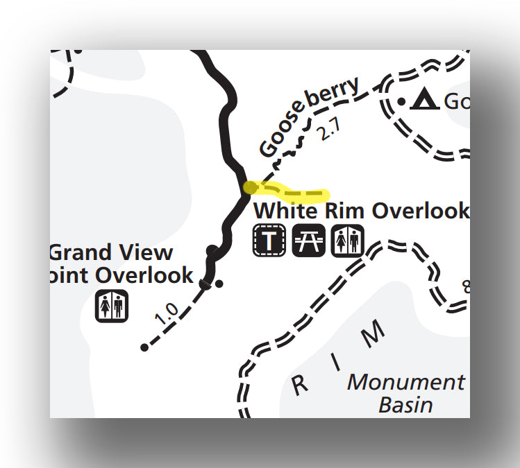

White Rim Overlook Trail map, courtesy of the National Park Service
If you are looking for a relatively short hike and easy hike with a great payoff at the end, then the White Rim Overlook Trail is for you. This 1.8-mile (round trip) climbs only about 170 feet on the way to a narrow point on the rim with amazing views.
One great thing about this trail in particular is that it is not crowded at all, as most who visit this part of the park venture out on the Grand View Point trail instead. The views from this trail are out to the east, making it quite a different vantage point and worth doing both (if you have the time). The White Rim Overlook Trail parking area also has covered picnic benches and bathrooms.
The White Rim Overlook Trail is accessed by heading south on Grand View Road about 5.2 miles from the intersection with Upheaval Dome Road.
SLICKROCK TRAIL
- Difficulty: Easy
- Distance (round-trip): 2.2 miles
- Elevation gain: 135 feet
- Hiking time (approximate): 1 to 1.5 hours

Slickrock Trail map, courtesy of the National Park Service
The Slickrock Trail is an easy and short trail. At just 2.2 miles (round-trip), this loop trail only climbs a total of 135 feet over its distance.
The trail has several really great viewpoints of the Needles District as a whole. You may even find bighorn sheep on this hike! The surface is a bit uneven and you’ll have to watch your step, but the cairns (rock piles) will help guide you on the trail.
The Slickrock Trail is located at the Slickrock Trailhead, which is 6.2 miles from the Needles District Visitor Center.
FURTHER INFORMATION ON CANYONLANDS NATIONAL PARK FROM JUST GO TRAVEL STUDIOS
- We review these trails and many more in our downloadable itinerary for Canyonlands National Park. If by any chance you also want to head out to other parks in Utah, then check out our Utah’s Big 5 National Park itinerary, which is offered at a discount!
- We cover the area’s best hikes in our blog on the Best Hikes in the Moab Utah area. You will want to check out the amazing places nearby Canyonlands!
- We cover Canyonlands in detail in our blog, What to See and Do in Canyonlands National Park. You can also check out our blog on hiking the Mesa Arch Trail.
- Don’t forget that we also create custom, vintage-style posters, postcards and note cards using photos that you send us. We’re happy to help you remember your trips forever!

ADDITIONAL USEFUL INFORMATION ON CANYONLANDS NATIONAL PARK
- Another great activity in Canyonlands National Park is rafting. For some details on what it’s like to experience an amazing 7-day adventure, Wayne Ranney (from “Earthly Musings”) put together information about Rafting and Hiking in Stillwater and Cataract Canyons in Canyonlands National Park.
- If you need ideas on how to spend your time when visiting Moab (beyond Canyonlands National Park!), check out Leigh’s blog (from “Hike Bike Travel”) on The Ultimate Itinerary for a Visit to Moab, Utah.

