8 Best Hikes in Arches National Park: Trail Maps, Directions & More
Peter BrahanPicking the best hikes in Arches National Park isn’t easy. The park is full of amazing views and many of these views are accessible from the main park road, if not a short stroll from a pullout. However, to really see the park you have to get up close and personal, and getting out on the hiking trails is the best way of doing that.
The best hikes in Arches National Park range from a number of easy hikes to more difficult hikes. Depending on the weather and time of year, visitors to Arches really have a ton of options for all types of hiking capabilities.
It was a challenge to narrow down the list, but here are what we think are the best hikes in Arches National Park!
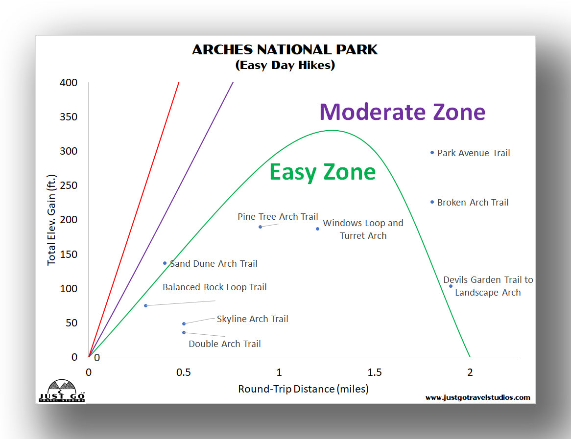
ARCHES NATIONAL PARK HIKING: DISTANCES AND ELEVATION GAIN
It’s hard to really go wrong when you are trying to select the best hike to take in Arches National Park. It actually really depends heavily on what level of difficulty you want and how long you want to hike. Of course, the advantage of the more challenging and longer hikes is that they will likely be less crowded. However, if you only have a limited amount of time, don’t hesitate to get out there on the shorter trails either. Even though you may have to deal with a few more people, you are sure to have a great time and be able to enjoy some breathtaking scenery.
If you are interested in easy or moderately easy day hikes, the chart below should help get you started.
For some longer or more challenging hikes, then the chart below should really come in handy as well.


BEST HIKES IN ARCHES NATIONAL PARK: TRAIL DESCRIPTIONS AND TRAIL MAPS
DELICATE ARCH TRAIL
- Difficulty: Moderate
- Distance (round-trip): 2.0 miles
- Elevation gain: 610 feet
- Hiking time (approximate): 2 hours
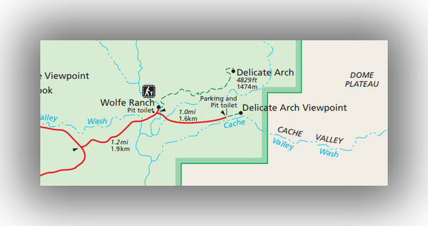
Delicate Arch Trail map, courtesy of the National Park Service
For those looking for a moderately challenging hike, the Delicate Arch Trail is definitely a must-do. This iconic arch is reached after climbing 610 feet in elevation with a total round-trip distance of 3 miles.
The trail starts with a steady uphill climb that lasts just over a mile. While not steep, this climb is exposed the entire way. After the climb, the trail is partly in the shade as hikers make their final push to the arch.
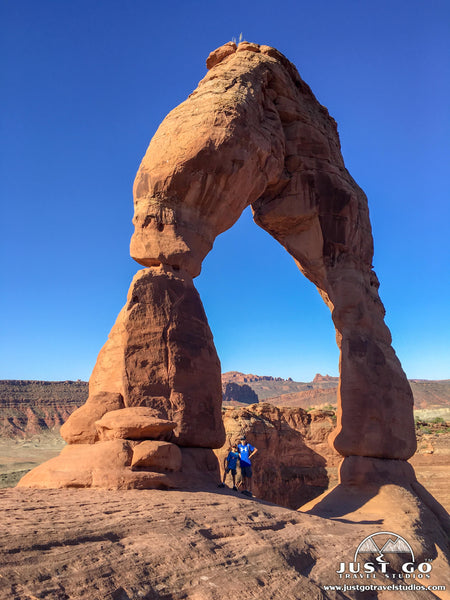
Delicate Arch is breathtaking. A large amphitheater-like formation rock allows hikers to rest (in the shade if you hike it in the morning) while taking in the view. It really is an amazing sight.
If you happen to hike in the middle of summer (like we did), be prepared for this challenge by taking plenty of water with you on the trip. Starting early in the morning is strongly recommended to avoid heat exhaustion. Also, this trail is very popular, so arrive by 8:30 in the morning if you are hiking during the busy times of year.
The trailhead is on Delicate Arch Road, which is about 12 miles north of the park entrance. Make sure you check out the petroglyphs and the Wolfe Ranch near the beginning of the trail.
DEVILS GARDEN TRAIL TO LANDSCAPE ARCH
- Difficulty: Easy / Moderate
- Distance (round-trip): 1.9 miles
- Elevation gain: 110 feet
- Hiking time (approximate): 1 hour
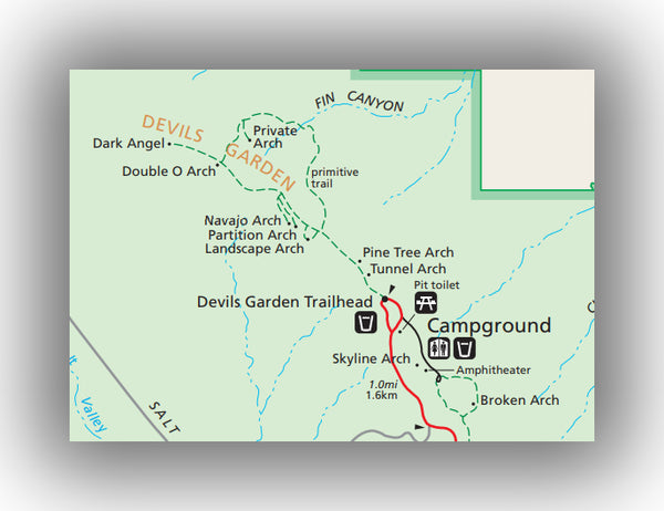
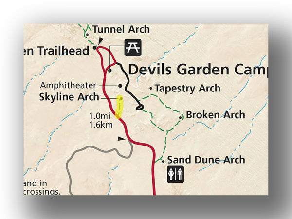
Devils Garden Trail map, courtesy of the National Park Service
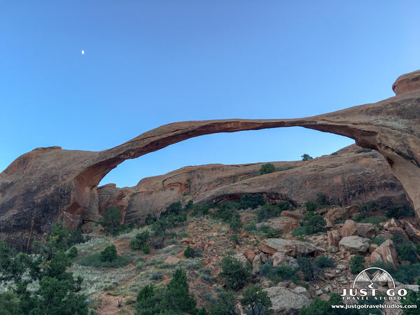
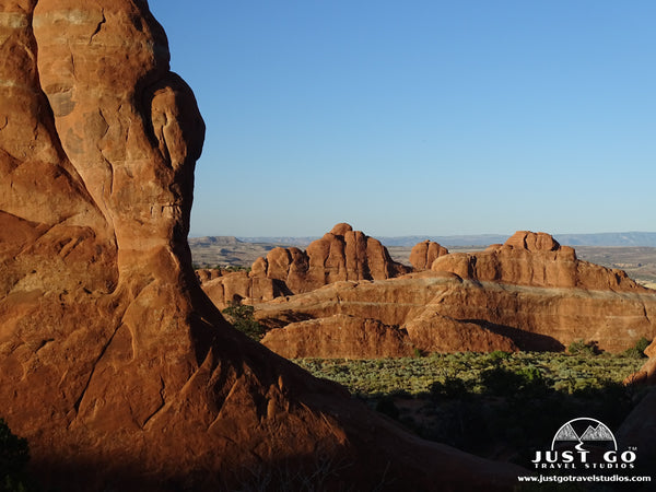
From the Devils Garden Campground there are several great hikes and one of the best in the park is the Devils Garden Trail to Landscape Arch. This is an easy-moderate hike that is relatively flat through red rock formations on its way to one of the most fragile arches in the park. This hike has a round-trip distance of 1.9 miles, will take approximately 1 hour and has a total elevation gain of just over 100 feet.
After starting from the large parking lot the trail starts on a paved trail (which can get quite crowded). After about 0.75 miles, the trail starts to get sandy and becomes a bit more difficult to hike on as it climbs a shallow incline up to landscape arch. This amazing arch extends more than 100 yards in total length and is sure to impress.
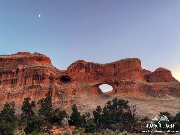
On the return trip, take a slight detour to visit Pine Tree Arch and Tunnel Arch. Tunnel Arch (in particular) is a place for great photos.
The trailhead starts at the end of the Park Road, which takes about 45 minutes from the park entrance. This hike can get very crowded, so be prepared to be patient in the large parking lot.
Hike Option: Take the Devils Garden Trail another 1.1 miles to the Double O Arch and Dark Angel, or take the entire Primitive Trail for the full 7.2-mile loop to see Private Arch as well. This is a long journey in the heat, but if you come here in the winter or spring this can be a great option.
SAND DUNE ARCH TRAIL
- Difficulty: Easy
- Distance (round-trip): 0.2 miles
- Elevation gain: 130 feet
- Hiking time (approximate): 20 minutes
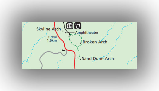
Sand Dune Arch Trail map, courtesy of the National Park Service
One of the shortest hikes in Arches National Park makes for a great trail for families. The Sand Dune Arch Trail arrives at Sand Dune Arch only 0.2 miles from the parking lot. With approximately 130 feet of elevation gain, the short distance and small amount of climbing makes it great for families or for hiking in the heat of the day.
Sand Dune Arch is unique in that there is a narrow passageway that you have to pass through on the way to the arch, which is surrounded by sandstone.
On this hike it’s possible to find some shade to relax in (depending on the time of day). While short, this trail is highly recommended!
The trailhead starts from the Park Road just about 1.2 miles before the Devils Garden parking area.
Hike Option: Continue 0.6 miles further to Broken Arch. This arch is also accessible from the Devils Garden campground and makes for a nice loop along with Tapestry Arch.
Sand Dune Arch photo courtesy of James St. John
DOUBLE ARCH TRAIL
- Difficulty: Easy
- Distance (round-trip): 0.5 miles
- Elevation gain: Minimal
- Hiking time (approximate): 30 minutes
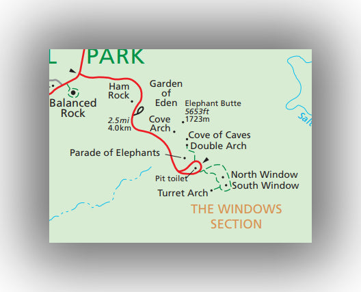
Double Arch Trail map, courtesy of the National Park Service
The Double Arch Trail is a great hike for families as well. At 0.5-miles (round trip), this trail barely climbs 30 feet on the way up to the site of an incredible set of arches. The trail is a sandy path, but it is well traveled and suitable for all ages.
This hike has a great reward for little effort and is a must-do.
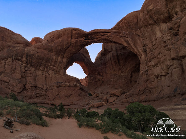
The trailhead starts from the Windows parking area, located about 9 miles north of the park entrance. Be sure to visit the North and South Windows as well as Turret Arch while visiting this area as well.
FIERY FURNACE TRAIL
- Difficulty: Moderate
- Distance (round-trip): 1.8 miles
- Elevation gain: 705 feet
- Hiking time (approximate): 1.5 to 2 hours
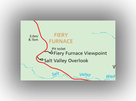
Fiery Furnace Trail map, courtesy of the National Park Service
The Fiery Furnace Trail was one of the highlights of our visit and is without a doubt one of the best hikes in Arches National Park. This 1.8-mile round trip, guided hike takes adventurers into the heart of a seemingly unnavigable rock formation full of surprises around every corner. There is a total of around 700 feet of elevation gain.
The hike is slow-paced, but goes through many different types of rock formations. You’ll see a few arches and get to experience rock scrambling and climbing through narrow passages. You should be in good shape, have good balance and at least some upper body strength. Don’t be intimidated by this hike, but just make sure you are up for it!
For some great info on the hike, how to best be prepared and whether or not the hike is for you, check out this in-depth article, on Hiking the Fiery Furnace Trail in Arches.
The trailhead starts at the Fiery Furnace Parking area, 13 miles north of the park entrance. Note that you must have reservations to take this guided hike and they are able to be made many months in advance. Reservations for Fiery Furnace can be made here.
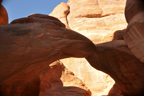
BROKEN ARCH TRAIL
- Difficulty: Easy
- Distance (round-trip): 1.8 miles
- Elevation gain: 225 feet
- Hiking time (approximate): 1 hour
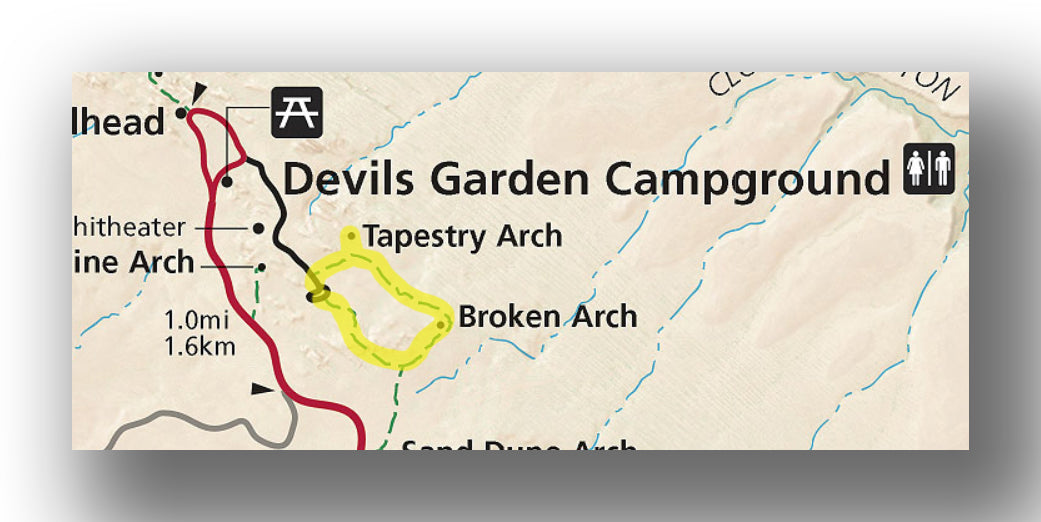
Broken Arch Trail map, courtesy of the National Park Service
If you are in the mood for a fairly easy hike that is more than just a five minute stroll, then the Broken Arch Trail may be just the thing for you. This 1.8-mile (round trip) hike winds through the sandstone and a large meadow before arriving at the view of the Broken Arch. The loop also includes a small spur to the north that gives views of Tapestry Arch. Be advised that there is a bit of rock scrambling near Tapestry Arch.
Most of the trail is quite flat, though if you head counterclockwise on the loop you will have a small steep section about 0.2 miles on the way in. There is a total of around 225 feet elevation gain throughout the hike.
The trailhead starts at the Devils Garden campground.
Broken Arch photo courtesy of buzyredhead
SKYLINE ARCH TRAIL
- Difficulty: Easy
- Distance (round-trip): 0.5 miles
- Elevation gain: 50 feet
- Hiking time (approximate): 30 minutes
Skyline Arch trail map, courtesy of the National Park Service
A short hike that provides a great view without much work is the Skyline Trail. This 0.5-mile (round-trip) hike takes only about 15 minutes on the way out prior to coming to a distant view of Skyline Arch.
The trail is almost all flat, and you’ll only go up about 50 feet in elevation throughout the trail. It is also a great hike to do in the evening, as you can get away from the main road and see the night sky.
The trailhead starts near the end of the main road at the Skyline Arch parking area. You can also walk from the Devils Garden campground or the parking area at the end of the main road.
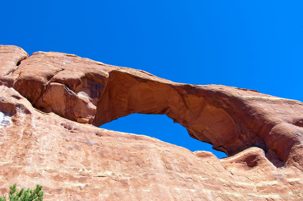
Skyline Arch photo courtesy of Mike Goad
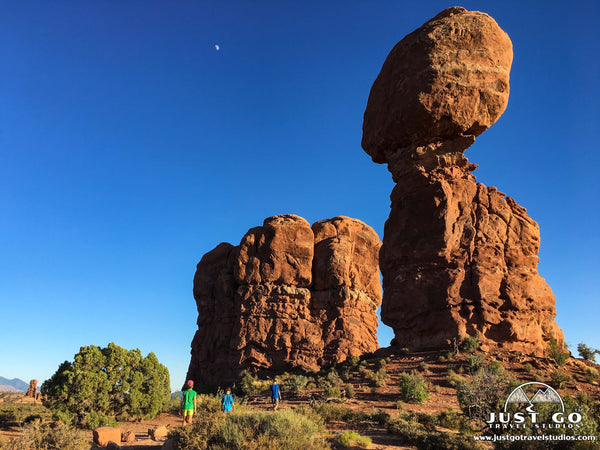
BALANCED ROCK LOOP TRAIL
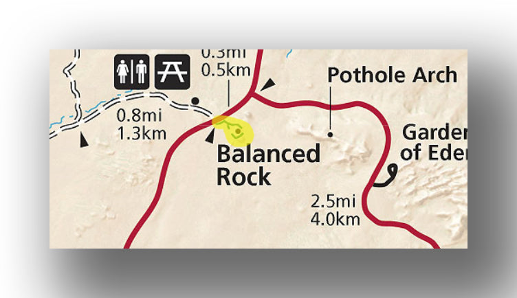
Balanced Rock trail map, courtesy of the National Park Service
If you are looking for a great hike to do with the kids, then the Balanced Rock Loop trail is it. This flat trail is only about 0.3-miles long in its entirety. Our kids loved skipping along the trail with great views of Balanced Rock-a towering natural structure that is perched high above the trail. Really, you’ll be amazed that this rock hasn’t fallen!
The trailhead starts about 9 miles north of the park entrance on the east side of the road.
FURTHER INFORMATION ON ARCHES NATIONAL PARK FROM JUST GO TRAVEL STUDIOS
- We cover information all these trails and more in our itinerary for Arches National Park.
- Be sure to read our detailed blog on What to See and Do in Arches National Park.
- If you are flying into the area, read our blog on the Closest Airports to Arches National Park. We also cover Camping in and near Arches National Park.
- We covered the Fiery Furnace trail in detail in our blog, Hiking the Fiery Furnace Trail. This hike is incredible and something you’ll want to check out! We also go into detail on the Delicate Arch Trail and Devils Garden Trail to Landscape Arch in our dedicated articles that you’ll want to read ahead of your trip as well.
- Arches National Park is one of many great places in the area, so make sure you check out our blog on the Best Hikes in Moab.
- After your trip, send us a photo so we can create custom, vintage-style posters, postcards and note cards that are personalized and made just for you!

ADDITIONAL USEFUL INFORMATION ON ARCHES NATIONAL PARK
- Nearby Arches National Park is Dead Horse State Park. Jamie (from “PhotoJeepers”) put together a great guide on what to do in Dead Horse State Park. She also has a ton of great info on photography.
- Traveling with a dog? Arches isn’t the best place, but Alicia (from “Girl on a Hike”) covers the best hikes with dogs in Moab.