Trail of the Cedars in Glacier National Park
Peter BrahanHiking the Trail of the Cedars in Glacier National Park is one of the most popular activities along the Going-to-the-Sun Road. Not only is it one of the easiest and most accessible hikes to people of all ages, skill levels and physical conditions (including wheelchair accessible), it is also in a location that is likely already on your planned route in the park.

Though the trail is only 0.8-miles in total, you’ll feel immediately immersed in a thick grove of trees. Since the trail is a loop, even the kids won’t get bored at all along this hike. There is also a wonderful side trip to Avalanche Gorge, accessible only after a short incline if you are up for it!
If you are in the mood for a relatively short, flat hike with plenty of scenery and a lot of shade, then hiking the Trail of the Cedars is definitely recommended for you!
TRAIL OF THE CEDARS DETAILS
- Difficulty: Easy
- Distance: 0.8 miles (round-trip)
- Trail: Loop
- Elevation gain: 341 feet
- Peak elevation reached: 3,445 feet
- Best time of year to hike: Early summer to fall
- To beat the crowds: Arrive before 8:00 am or after 3:30 pm
- Footwear: Sneakers
- Watch out for: Mosquitoes, bears
- Restrooms: Located at the trailhead and on the trail
- Pets: Not allowed
- Time needed: 30 minutes
Ahead of your trip, we recommend downloading our 16+ page Glacier National Park itinerary. This guide gives you a head start on your trip planning, covering all the recommended day-hikes in the park. We rank them for you as well, and include what to pack, where to stay and what else to do while you are in the area.
PARKING AND TRAILHEAD FOR THE TRAIL OF THE CEDARS

Map of the Trail of the Cedars trailhead, courtesy of the National Park Service
The parking area for the Trail of the Cedars is right across from the Avalanche Creek campground, which is along the Going-to-the-Sun Road.
Ahead of heading out to Glacier National Park, make sure you check the status of the Going-to-the-Sun Road. Logan Pass (which is the peak of the road) is commonly closed between October and early July, though the portion of the road needed to get to Trail of the Cedars from the west is usually open earlier in the summer. Either way, be sure to check ahead.
The trailhead is located about 15.6 miles east of the west entrance to the park, 15.5 miles from Logan Pass and about 33 miles from the St. Mary (east) entrance to the park.
- Directions from the Glacier National Park west entrance to the Trail of the Cedars trailhead (this will take about 30 minutes after you make your way through the park entrance).
- Directions from Logan Pass to the Trail of the Cedars trailhead (this will take about 40 minutes, or a little less without traffic).
The Trail of the Cedars parking area has room for around 100 cars. Even if you get here at 7:30 am, you’ll feel a bit rushed and pressured to find a parking spot, as this place fills up fast. However, since many people are only hiking the short loop, spots do open up regularly. That being said, if you come here after 8:30 am, expect to have to hunt around for a parking spot!
There are restrooms right across the street (on the west side) of the Going-to-the-Sun Road and the entrance to Trail of the Cedars. They are near the entrance to the Avalanche Creek campground. These restrooms can be very busy, though, so be prepared to wait in line if you are coming here during busy times of day.
In addition to restrooms at the campground, there are also restrooms along the trail. These restrooms are much less crowded, and depending on your walking speed, they are generally only about 15-20 minutes away from where you park.
Finally, this is also a great place to have a picnic. There are picnic tables on the west side of the road. There are also great places to stop along the hike for lunch or a snack. While you could go to one of the concession locations (at Lake McDonald Lodge, for instance), we always love eating while on a trail like this and find it much more enjoyable and memorable!
HIKING ALONG THE TRAIL OF THE CEDARS TRAIL

Trail of the Cedars trail map, courtesy of the National Park Service
After leaving the car you’ll have to decide which way to start the loop-on the west or east side. For some reason, most people tend to travel on the east (boardwalk) side first, but there really aren’t any set rules or recommendations on what the best approach is. We’ve hiked this multiple times and traveled both ways-since there is no elevation gain to speak of, there really isn’t any preferred path.

Of course, if you have to use the restroom and don’t want to use the facilities at the trailhead, it is a slightly shorter route to hike by starting off on the west side (to the right)!
For the purposes of this guide, we’ll assume you are starting off on the east (left) side of the trail and trekking along the boardwalk first.
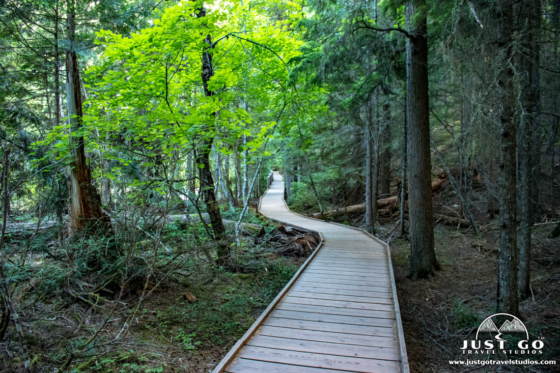
Immediately after starting off on the trail, you’ll be walking along a fairly-wide, well-maintained boardwalk. This side of the trail is completely immersive-the trees are tall and dense, making it on the darker side and quite mossy.

Along the boardwalk are interpretive signs to help explain the area. Also keep your eyes out for park rangers-they are frequently on-hand to answer any questions you may have about the trail or local flora.
Most of the trees are either western hemlocks or red cedars:
- Western hemlocks (native to the northwest of the United States) can grow to be over 200 feet tall with a tree diameter of 9 feet. Believe it or not, these trees can live to be over 1,000 years old!
- Red cedars are one of the most common trees in the Pacific Northwest and can also grow over 200 feet in height. Their trunk can reach up to 13 feet in diameter!

After hiking about 0.4 miles, the trail comes upon a footbridge over the Avalanche Creek at the bottom of the Avalanche Gorge. This is a great spot for photos!

At this point, the trail keeps going and returns via the west side. At the very end of the loop (halfway through the trail), there is a junction with the Avalanche Lake Trail (see our blog). This hike, including the Trail of the Cedars portion, extends the hike to a total of 4.4 miles (round-trip). However, if you want to get a great, quick view of some amazing scenery, walk up the trail for only about 0.2 miles and you’ll see the top of Avalanche Gorge. The rushing water here is incredible.


On the western side if the hike, the trail is all packed dirt and continues through the forest, although it is not nearly as dense as the eastern side of the trail and is even intertwined with small meadows. It’s not uncommon to see deer on this hike, particularly on the west side of the trail.

Though infrequent, bear sightings do occur here, so it’s a good idea to bring bear spray with you and to make sure you know how to use it!
We should also note that one thing that made this hike special for us is the silence. Even though there were many hikers on the trail during our visit, everyone made an effort to really keep their voices low. This was much appreciated and really added a special element to the hike!

FURTHER INFORMATION ON GLACIER NATIONAL PARK FROM JUST GO TRAVEL STUDIOS
- Ahead of your trip, be sure to download a copy of our itinerary for Glacier National Park. It’s packed full of information that you’ll find invaluable to have ahead of your trip (and during it!).
- We have an extensive blog that covers a high level view of the park, 10 Reasons Why You’ll Love Glacier National Park.
- Other hikes that we loved in Glacier National Park were the Iceberg Lake Trail and the Avalanche Lake Trail. We have blogs for both that cover the hikes in great detail! You also won’t want to miss the Hidden Lake Trail. It was one of our favorites in the park, for sure!
- Before you leave, read our blog What to Pack for your trip to Glacier National Park and all about Glacier National Park Campgrounds. And if you need an airport to fly into, then check out our blog on the Best Airports Near Glacier National Park.
- We offer WPA Style Posters for many of the National Parks-be sure to check out our Glacier National Park poster that features the Going-to-the-Sun Road.

- When you get back from your trip make sure you send us a photo so we can make a custom, vintage-style travel poster for you!


