15 Best Hikes in Rocky Mountain National Park: Trail Maps, Directions & More
Peter BrahanOf all the things to do in Rocky Mountain National Park, there is nothing like hiking on one of the great day hikes in Rocky Mountain National Park. From easy trails that take less than an hour to trails that take the better part of a day and will challenge even the most seasoned hiker, there is something for everyone here.
There are literally many dozens of hikes to choose from in this park, so it’s hard to pick what really is the best. We hope that this list helps to narrow down some great options for you and your travel partners to take on during your time in the park, which will seem limited, even if you plan on staying here for more than a week!
WHAT ROCKY MOUNTAIN NATIONAL PARK HIKE IS RIGHT FOR ME?
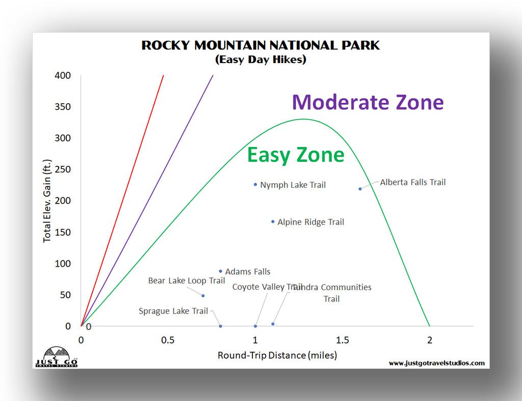
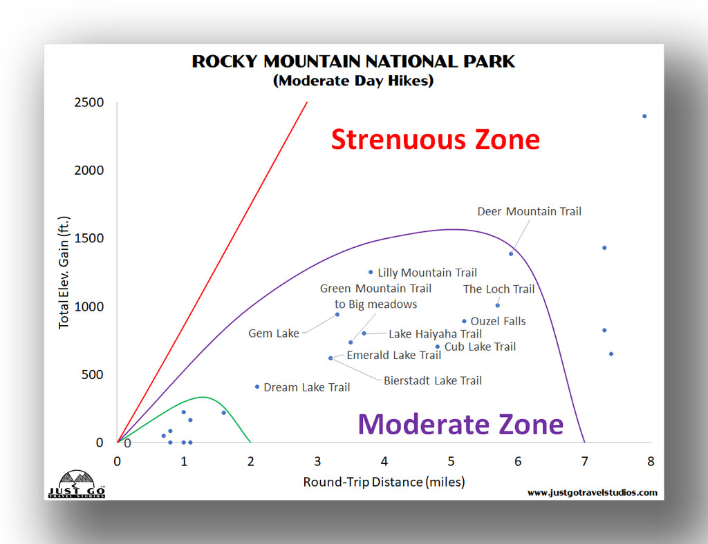
To help you get an overview of what might be right for you, we thought we’d put together some useful graphs which chart each hike by elevation gain vs. distance.
Here are some of the easier day-hikes that you can take on:
If you are in the mood for something that takes a bit longer but is well-suited for most members of any hiking group, then the moderate hikes may be right for you:
Finally, the most strenuous day-hikes are an option for you as well. Here are a few choices:

Our Rocky Mountain National Park Itinerary helps you plan your trip to Rocky Mountain National Park. We cover the hikes in this blog (and many more!) as well as cover where to stay and camp, what to pack and what else to be sure you see when you are in the area.
DEER MOUNTAIN TRAIL
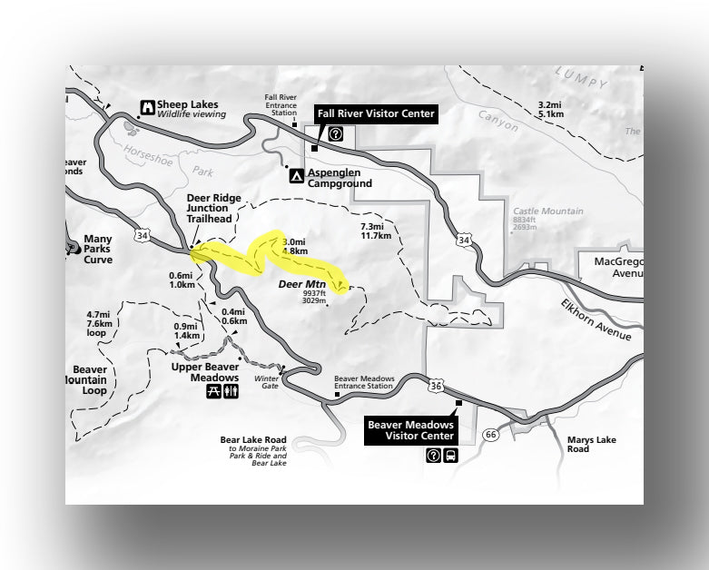
Deer Mountain Trail map, courtesy of the National Park Service
The Deer Mountain Trail is a moderately challenging hike. This hike starts off in a valley and heads up steadily before entering a forest along with a set of steeper switchbacks about halfway up the trail. At the top, you’ll be rewarded with amazing panoramic views! This hike is highly recommended.
The entire hike is about 5.9-miles long (round-trip) and you will have an elevation gain of just under 1400 feet. The hike will take about 3-4 hours.
The Deer Mountain trailhead is located at the Deer Ridge Junction, where Highways 34 and 36 meet. Click here to find out more information on the Deer Mountain Trail.
FERN LAKE TRAIL
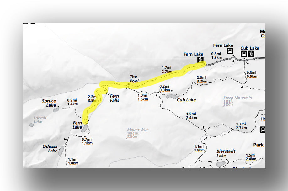
Fern Lake Trail map, courtesy of the National Park Service
This trail heads along a river through a forest. There are a few open parts of the trail where you’ll see wildflowers if you hit it at the right time of year. About 1.7 miles in, there is a place called the “Pool” where two rivers meet. This is a great place for a break before continuing on. When the trail ends at Fern Lake, there are phenomenal views of several area peaks.
In total, the hike is about 7.3-miles long (round-trip) and climbs about 1400 feet in elevation. You should plan on taking about 4 hours to hike this trail.
The Fern Lake trailhead is located about 2.8 miles west of the Moraine Park Discovery Center. Click here to find out more information on the Fern Lake Trail.
EMERALD LAKE TRAIL
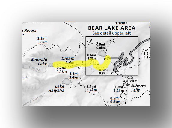
Emerald Lake Trail map, courtesy of the National Park Service
One of the most popular hikes in the park is the hike to Emerald Lake. The moderate hike passes by Nymph Lake while climbing steadily through the woods for the first mile and flattens out near Dream Lake before one last ascent up to Emerald Lake. The hike is relatively easy, but you will have to navigate some rocks along the way. At the end, there are views of Flattop Mountain along with other peaks.

The hike is about 3.2-miles (round-trip) with just over 600 feet of elevation gain. You should plan on it taking between 1.5 and 2 hours, plus whatever time you want to spend at the lake.
The Emerald Lake hike begins at the western end of the Bear Lake Parking lot.
SKY POND TRAIL
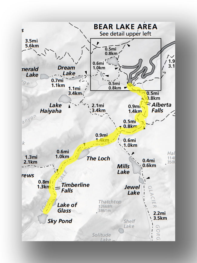
Sky Pond Trail map, courtesy of the National Park Service
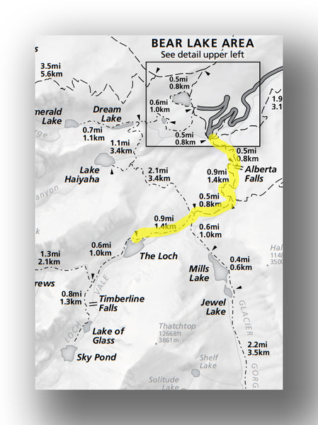
This challenging trail starts off by following the same route that many take to Alberta Falls (see Alberta Falls Trail). After the falls, continue on the Glacier Gorge trail until you see signs to head onto the Loch Vale trail. After you are on the Loch Vale trail, the trail gets steep at points before you reach the Loch. This is a beautiful lake has a backdrop of area mountains (Taylor Peak and Taylor Glacier, most notably).
After the Loch, you’ll climb further until you arrive at Sky Pond. There is rock scrambling involved, and this can be quite challenging. This is a wonderful trail, and for those who can handle the trip, it’s well worth the time and effort.
The entire hike is about 8.4-miles (round-trip) and you’ll have a total of about 1700 feet of climbing throughout the trail. Expect it to take about 6 hours in total.
The trailhead for the Sky Pond Trail starts from the Glacier Gorge Trailhead, just before the Bear Lake Parking Lot on Bear Lake Road.
ALBERTA FALLS TRAIL
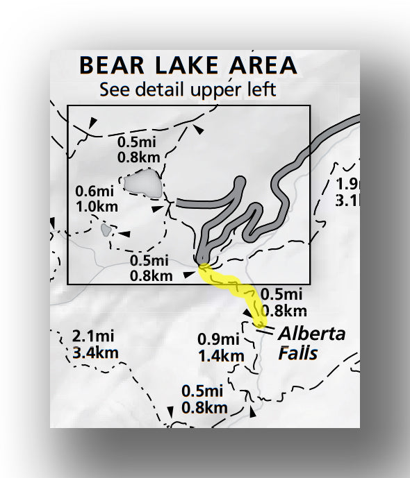
Alberta Falls Trail map, courtesy of the National Park Service
The hike to Alberta Falls is a relatively easy one (though not as easy as Bear Lake). The trail passes through aspen trees before opening up to a granite rock area. At the end, there is the gorge and Alberta Falls, which is a very impressive sight.
Alberta Falls is a great place to picnic, as you’ll be able to overlook the 30-foot falls. You can also reach Alberta Falls from the Bear Lake parking area. Finally, Alberta Falls can also be seen when heading back from the Loch or Sky Pond, or if you are taking the Haiyaha Cutoff Trail while coming back from / going to Haiyaha Lake.

The hike is only about 1.6-miles (round-trip) with a total elevation gain of just over 200 feet. Expect the trip to take a bit over an hour, plus time at the falls.
The trailhead for the Alberta Falls Trail starts from the Glacier Gorge Trailhead, just before the Bear Lake Parking Lot on Bear Lake Road.
LOCH TRAIL
Loch Trail map, courtesy of the National Park Service
This moderately-challenging hike starts off by following the same route that many take to Alberta Falls (see Alberta Falls Trail). After the falls, continue on the Glacier Gorge trail until you see signs to head onto the Loch Vale trail.
After you are on the Loch Vale trail, the trail gets steep at points before you reach the Loch. This is a beautiful lake has a backdrop of area mountains (Taylor Peak and Taylor Glacier, most notably. Many combine this hike with a hike to Sky Pond, which adds on 2.7 mi and a couple hours.
The hike is about 5.7-miles (round-trip) with just over 1000 feet of elevation gain. You can expect the hike to take about 3.5 to 4 hours, depending on how much time you spend at sites along the way.
The trailhead for the Loch Trail starts from the Glacier Gorge Trailhead, just before the Bear Lake Parking Lot on Bear Lake Road.
BEAR LAKE LOOP
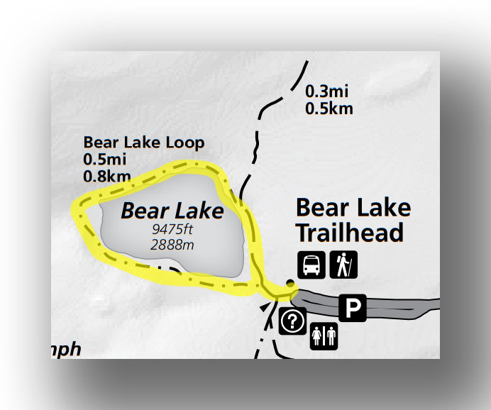
Bear Lake Loop Trail map, courtesy of the National Park Service
The Bear Lake Loop Trail is an easy hike that is well worth doing. Head north at the trailhead (the trail on the right). This trail is known for having great mountain views in the background of Bear Lake. This trail is ridiculously crowded, so just be prepared. It is good to do it as a “cooldown” from a longer hike as well.
The Bear Lake Loop Trail is 0.5-miles (round-trip) and has an elevation gain of only about 50 feet. Expect it to take about 30 minutes, hiking at a leisurely pace.
The Bear Lake Loop Trail starts from the western end of the Bear Lake parking lot.
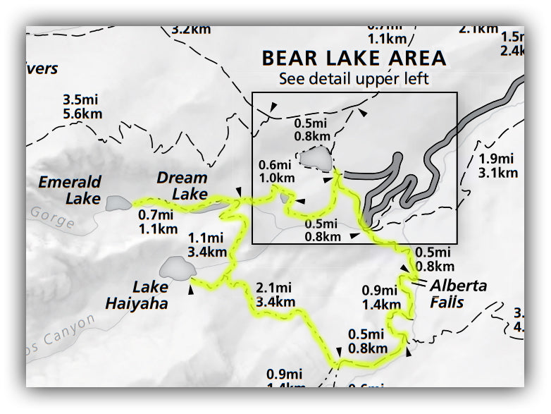
NYMPH LAKE, DREAM LAKE, EMERALD LAKE, LAKE HAIYAHA AND ALBERTA FALLS LOOP
Bear Lake Area Trail map, courtesy of the National Park Service
The trail combines a few great hikes into one. While long, it’s not overly challenging. Start off by heading to Emerald Lake. After you turnaround, you’ll trace your steps back until you see signs to Lake Haiyaha. Take this trail to Lake Haiyaha, before retracing your steps again for approximately 0.2 miles.

Pickup the Haiyaha Cutoff Trail that heads to meet up with the Glacier Gorge Trail. Take this trail down past Alberta Falls and head back to the Bear Lake Parking lot. This is a great hike. While you are on the Haiyaha Cutoff trail, it will be rare to see anyone else, as it is not a heavily traveled trail. This trail is highly recommended.

You can read more about this amazing hike (one of our favorites) in our blog on the hike to Lake Haiyaha.
The hike is about 8.1-miles (round-trip) and has an elevation gain of about 1250 feet. Expect the hike to take about 4 hours, plus any time that you want to spend just hanging out near the lakes.
The trailhead for this hike is located on the western end of the Bear Lake parking lot.
DREAM LAKE TRAIL
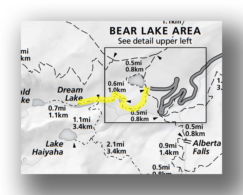
Dream Lake Trail map, courtesy of the National Park Service
The hike climbs steadily through the woods on the way to Dream Lake. This also includes passing by Nymph Lake. This is part of the Emerald Lake hiking route, so be advised that it is very crowded. This is a nice hike, but if you have the time, continue onto Emerald Lake (highlighted earlier) for the best experience.

The hike is about 2.1-miles (round-trip) and has an elevation gain of about 400 feet. You can plan on the hike taking about 1 hour.
The Dream Lake hike begins at the western end of the Bear Lake Parking lot.
BIERSTADT LAKE TRAIL
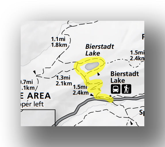
Bierstadt Lake Trail map, courtesy of the National Park Service
After climbing back and forth through a set of switchbacks, the trail comes upon Bierstadt Lake. The trail is beautiful the entire way, with views of the mountains. After you come upon the lake, the trail heads around the lake (which is optional, but included in the distance of this hike).
There are plenty of places to stop and have some chance of being by yourself while enjoying scenery.
The hike is just over 3 miles (round-trip) and has an elevation gain of just over 620 feet. The hike will take about 2 hours.
The Bierstadt Lake hike begins at the Bierstadt Lake Trailhead, which is in the Bear Lake area before you reach the Bear Lake parking lot.

Bierstadt Lake, image courtesy of Wildernest42
LULU CITY TRAIL
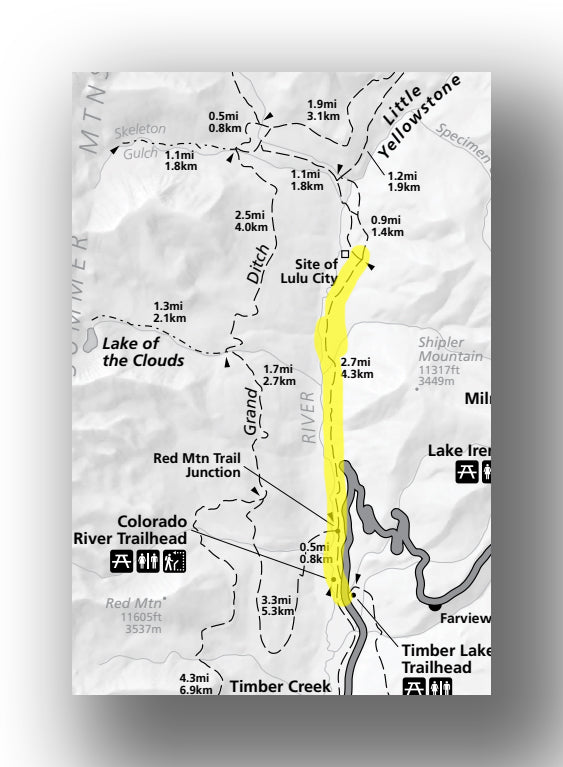
Lulu City Trail map, courtesy of the National Park Service
This out-and-back trail is fairly easy. After starting with little incline for nearly two miles before heading up. The views are average until it opens up as you near Lulu City. Lulu City was a mining town from 1879 to 1883, but the only remaining structure is a log cabin.

The Lulu City hike is about 7.3-miles (round-trip) and has an elevation gain of 820 feet. It will take about 4 to 5 hours, including time to explore what is left of the site.
The Lulu City hike starts at the Colorado River trailhead just north of Timber Creek.
ALPINE RIDGE TRAIL
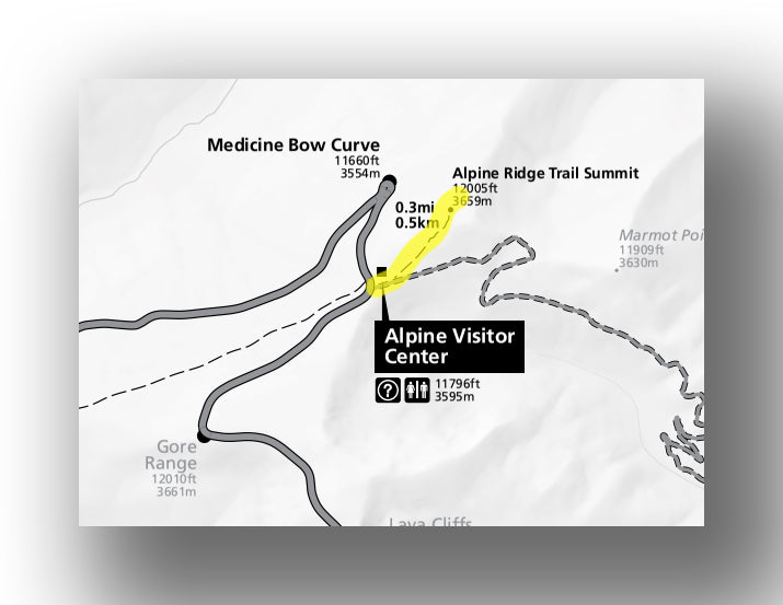
Alpine Ridge Trail map, courtesy of the National Park Service
This short, out and back trail is essentially all rock stairs that lead up to the 12,005 ft. summit. The views are great and wildflowers are plentiful when in bloom. This will be some of the more challenging stairs that you climb, however, as the air is very thin! Make sure you bring your camera.

The hike is only about 0.6-miles (round-trip) and has an elevation gain of about 135 feet. Plan on taking about 30 minutes for the hike.
The Alpine Ridge trail starts at the parking area for the Alpine Visitor Center.
ADAMS FALLS TRAIL
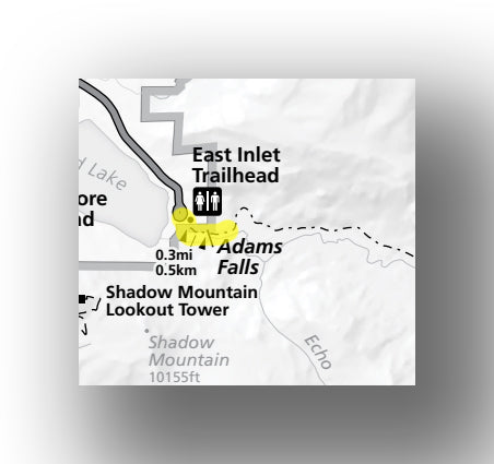
Adams Falls Trail map, courtesy of the National Park Service
This is an easy trail (but popular) to falls that really flow. There are great views along the way. Keep an eye out for wildlife along the trail or in the swamp area.
The entire hike is just under a mile (round-trip) with only about 90 feet of elevation gain.
The Adams Falls trail begins at the east end of Grand Lake.
OUZEL FALLS TRAIL
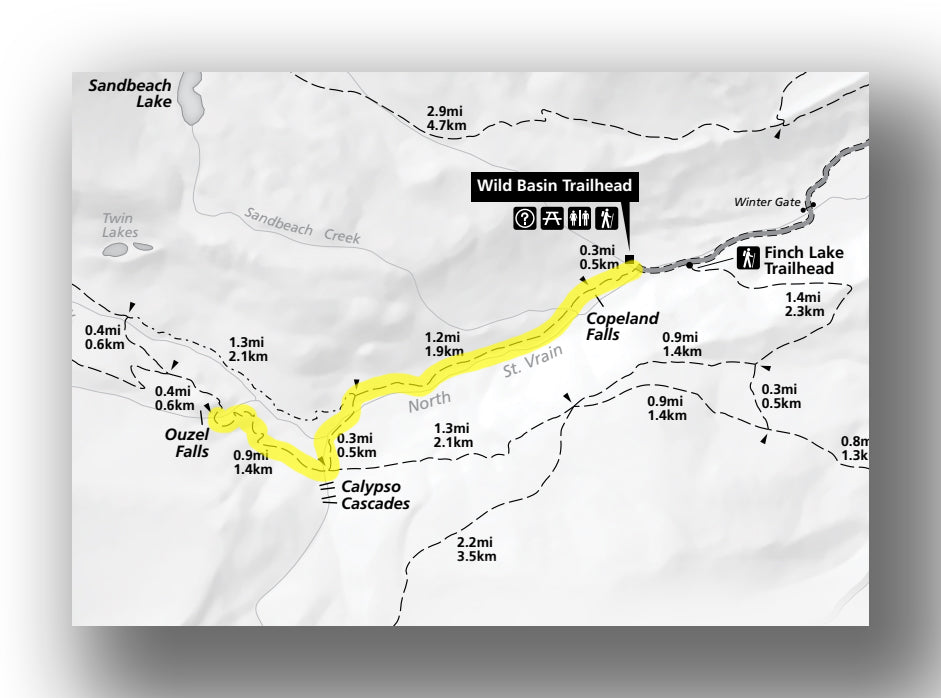
Ouzel Falls Trail map, courtesy of the National Park Service
This trail continues past Copeland Falls and Calpyso Cascades on its way to Ouzel Falls. After passing by the cascades, the trail leaves the Creekside and continues uphill to the amazing Ouzel Falls. This is one of the top trails in the entire park and highly recommended. Continuing to Ouzel Lake adds 4.5 miles and about 700 ft. of elevation. While not challenging, it can be long, and the lake is marshy with not a ton of space to sit and relax.
The hike is 5.2-miles long (round-trip) with an elevation gain of about 900 feet. It will take close to 3 hours to do the entire hike, plus time to rest at the falls.
The Ouzel Falls Trail begins at the Wild Basin Ranger Station, about 2.2 miles past the Wild Basin Entrance.
LILY MOUNTAIN TRAIL
This trail heads north before turning sharply to the southwest as it heads uphill for the rest of the hike to the peak. The last ¼ mile is steep. The views on this trail are amazing and it is one of the few trails in the area where dogs are allowed.
The hike is nearly 4-miles (round-trip) and has an elevation gain of about 1250 feet. Expect the hike to take nearly 3 hours.
The Lily Mountain hike starts before mile marker #6 when heading south outside of Estes Park at the Lily Mountain Trailhead.
FURTHER INFORMATION ON ROCKY MOUNTAIN NATIONAL PARK FROM JUST GO TRAVEL STUDIOS
- Ahead of your trip, be sure to check out our latest blogs on Rocky Mountain, including What to See and Do in Rocky Mountain National Park, Driving on the Old Fall River Road and Hiking the Emerald Lake, Lake Haiyaha and Alberta Falls Loop Trail.
- When you return from your trip, send us a photo and we’ll turn it into an amazing custom, vintage-style poster that is personalized and made just for you!