Misery Ridge Trail in Smith Rock State Park
Amy BrahanLocated in the high desert of Central Oregon, Smith Rock State Park is home to dramatic rock spires that rise above the winding Crooked River. The park is a world-famous destination for rock climbing, but Smith Rock also offers miles of trails for hikers to experience the diverse high desert landscape and majestic rock scenery. If you are seeking a challenging hike that yields great rewards, you must check out the Misery Ridge Trail!
MISERY RIDGE TRAIL DETAILS
- Difficulty: Strenuous
- Distance: 3.8 miles (round-trip)
- Trail: Loop
- Elevation gain: 760 feet
- Peak elevation reached: 3326 feet
- Best time of year to hike: Year-round
- To beat the crowds: Arrive before 8:30 am or after 3:30 pm
- Footwear: Hiking boots
- Watch out for: Sun exposure
- Restrooms: At the trailhead, but none on the trail
- Pets: Allowed on a leash
- Time needed: 2-3 hours
PARKING AND TRAILHEAD FOR THE MISERY RIDGE TRAIL
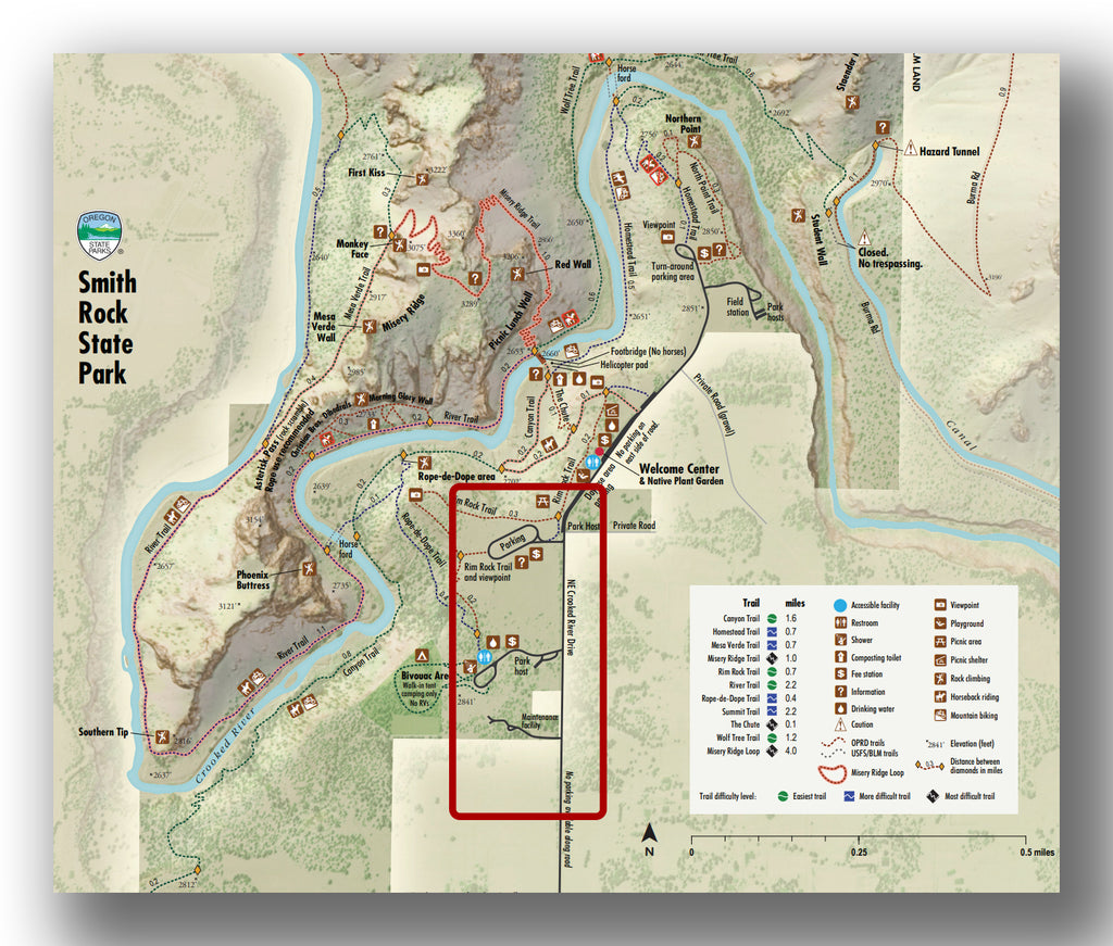
To access the Misery Ridge Trail, follow signs to Smith Rock State Park, on NE Crooked River Drive.
- Directions from Bend, OR to Smith Rock State Park (this is 26 miles and will take about 35 minutes, depending on how much traffic there is when leaving Bend, OR).

There are two main areas to park at Smith Rock State Park. If you arrive early enough, day-use parking is available near the main trail head on the west side of NE Crooked River Drive (there is NO parking on the east side of the road). There is space for 100+ cars on the west side of the road, including a few spots at the turn-around parking area at the end of NE Crooked River Drive by the Homestead Trail head.

There is also an overflow parking area on the left just before the Welcome Center. This parking lot is used for over-sized vehicles and buses and can hold about 90 vehicles.
Day-use parking permits are required and can be purchased from one of the green fee stations found along the park road and in the overflow parking lot. The fee is $5 per vehicle, unless you already have an Oregon State Parks Pass. Credit cards are accepted at fee stations; but it is best to have cash on hand, just in case. Don’t forget to display your parking pass or Oregon State Parks pass on your dashboard before heading out for your hike!
Flush-toilets are located to the left of the Welcome Center. There aren’t any bathrooms on the trail.
MISERY RIDGE TRAIL: TRAIL SURFACE, ACCESSIBILITY AND HIKING TIPS
- Trail surface. Misery Ridge is a steep, rough dirt trail with lots of switchbacks. The trail is mostly packed dirt with some dirt and wood stair sections on the way up the northeast side of Misery Ridge. The west side of Misery Ridge has lots of scree (loose rock) on the trail, so use caution when descending or hike the loop in the clockwise direction.
- Popularity. This trail is busy! You can see all that Smith Rock State Park has to offer from atop Misery Ridge, so it is no wonder so many people are willing to attempt this challenging hike. Arrive early in the morning to beat the crowds or during a weekday.
- Accessibility. This trail is not accessible for wheelchairs or strollers.
- Pets. Pets are allowed on the Misery Ridge Trail but must be kept on a leash no longer than six feet. Please clean up after your pet!
- Stay on the trail. To minimize erosion and the effects of foot traffic on native vegetation, please stay on established hiking trails.
- Leave no trace. Please keep our wild spaces beautiful by packing out all trash, including fruit peels and nut shells.

PREPARATION FOR HIKING THE MISERY RIDGE TRAIL
We recommend hiking the Misery Ridge Loop, which includes the Misery Ridge Trail, part of the Mesa Verde Trail and the River Trail. The hike will take 2-3 hours—probably closer to 2 but we took A LOT of photos! These are a few things we recommend you pack / wear for your hike:
- Water. Misery Ridge is the most strenuous trail in the park, so please hike responsibly and bring plenty of water. A hydration pack is a good option.
- Sun Protection. There is little to no shade on the trail. Bringing a hat and sunglasses and wearing sunblock is highly recommended. This area gets quite hot during summer months, so we also recommend doing this hike early in the morning or late in the afternoon to avoid the heat of the day.
- Daypack. You’ll want to have your hands free, so a daypack is helpful for carrying snacks and water. This is our favorite backpack that we’ve had for years.
- Shoes. We recommend wearing hiking boots or shoes with good tread (his and hers).
- Trekking Poles. Sturdy trekking poles are especially helpful on the steep scree sections.
- First-Aid Kit. We always bring along a hiking first-aid kit when hiking.
HIKING THE MISERY RIDGE LOOP
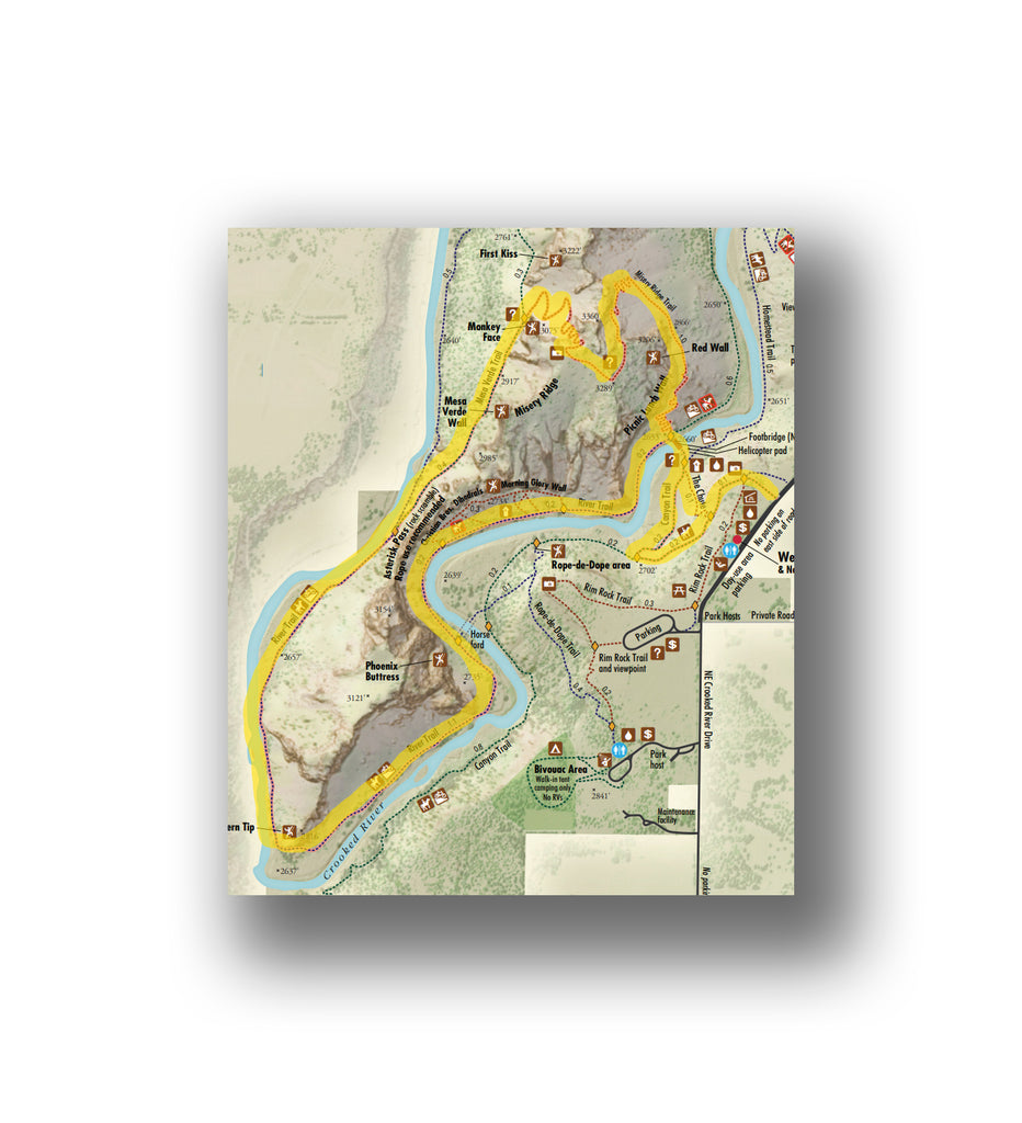
Smith Rock State Park trail map, courtesy of Oregon State Parks
From the Welcome Center, follow the Rim Rock and Canyon Trails down into the river canyon to the Crooked River bridge.

Immediately after crossing the bridge, you will see a sign for the Misery Ridge Trail, where the trail officially starts. The trail ascends the northeast side of Misery Ridge via a series of switchbacks and large wooden steps (which help hold the crumbing trail in place).

From the bridge to the summit, this challenging 0.7-mile portion of trail climbs 600 feet. Along the way, you’ll pass a couple popular destinations for climbers, Picnic Lunch Wall and the Red Wall, as well as Ship Rock.


Once at the summit, take a rest and enjoy the amazing panoramic views of the high desert! A large open rock provides a great view of the Monument Area to the east and the Crooked River and switchbacks below. Continue exploring the summit by following the trail which winds around to the west side of the ridge. You worked hard to get up here, so be sure to spend some time exploring all the summit views!

Before descending the west side of Misery Ridge, there’s a great overlook of Monkey Face, a dramatic rock spire frequented by rock climbers and slackliners. It is fascinating to watch climbers working their way up or descending from the rock pillar! On a clear day, you can see also see the distant peaks of Oregon’s Cascade Range to the west—including Mount Jefferson, the Three Sisters, Broken Top and Mount Bachelor.

Once you’ve had your fill, follow another series of switchbacks past Monkey Face and down the back side of Smith Rock. This section of the trail is extremely steep and has lots of scree (loose rock/sand), so use caution when descending. (This is where good hiking boots and poles, if you have them, come in handy!)


At the base of Monkey Face, the Misery Ridge Trail meets up with the Mesa Verde Trail. Head left and follow the trail downhill for 0.4 miles until it merges with the River Trail. Head left once again and enjoy the 1.1-mile stroll along the Crooked River, which winds around the south end of Smith Rock and back to the bridge. Follow the trails back uphill to the Welcome Center and parking areas.


NOTE: Although we chose to write up the description in the direction which we hiked (counterclockwise and straight up Misery Ridge), this loop is often hiked in the opposite direction, starting along the flat River Trail. The trail on the west side of Misery Ridge is steeper with lots of loose rock and sand, so some find it easier to hike up rather than down that sort of tricky terrain. The other advantage of hiking the loop in the opposite direction is to avoid the direct sun when ascending. On a hot and sunny day, much of the trail on the western side of Misery Ridge would be shadowed and keep a hiker cooler for the challenging climb to the ridge. We personally enjoyed getting the tough climb out of the way first, but I wouldn’t recommend it mid-day in the summer!

MISERY RIDGE LOOP: TOP LIKES AND DISLIKES
Likes:
- Expansive summit views. If you can put up with the “misery”, which is really not that bad if you are in moderate hiking shape, you’ll be treated to some awe-inspiring views of rock spires, the surrounding high desert and distant views of the Cascade Range. What’s not to like?!
- Rock climbers. It’s pretty darn impressive to watch rock climbers in their element. There are several great places along this hike to watch them to tackle one of many routes in the park.
Dislikes:
- Trail surface. Loose scree makes descent from Misery Ridge a bit of a challenge. Take your time, wear hiking boots and consider using hiking poles to avoid a nasty fall.
THINGS TO DO NEAR SMITH ROCK STATE PARK
In addition to Smith Rock State Park, Central Oregon has a lot to offer. In fact, there’s so much to do in the Bend area, you will want to allow at least a few days exploring! We’ve included a few options below:
- If you visit in the summer and don’t mind getting wet, try white water rafting on the Deschutes River or float down the Deschutes River in a tube right in downtown Bend!
- Drive the Cascade Lakes Scenic Byway. There are numerous hiking trails and lakes to be explored in this area of Deschutes National Forest.
FURTHER INFORMATION ON SMITH ROCK STATE PARK AND THE SURROUNDING AREA FROM JUST GO TRAVEL STUDIOS
- We highly recommend visiting Newberry National Volcanic Monument. Two great short hikes are the Big Obsidian Flow Trail and the Paulina Falls Trail. If you dare, drive the narrow winding road to the summit of Paulina Peak to be rewarded with amazing views!
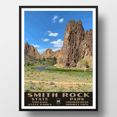
- If you had a great time at Smith Rock State Park, then perhaps you should check out our Smith Rock State Park Vintage Style Posters!
- Why use one of our images? Send us your own, and we’ll work with you to create a custom, vintage-style travel poster. This allows you to get the exact poster that you want, and it’s a really special gift as well!