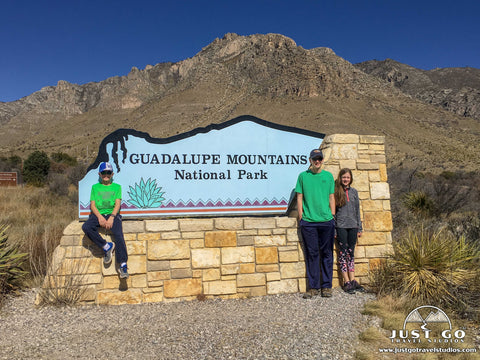
Guadalupe Mountains National Park: Things to Do, Maps & More
Peter BrahanHome to the highest point in Texas, Guadalupe Mountains National Park has spectacular views, diverse wildlife and interesting foliage throughout the park. Though it is one of the lesser attended and lesser known National Park Units in the United States, it is a fantastic place to explore. What makes this park unique is that there are very few roads to access the park’s most famous sights and viewpoints. However, with just a short walk, you can easily see some pretty impressive sights, making it good for all ages.
Certainly, to see the park in full, you’ll have to bring your hiking shoes and be prepared to do a bit of trekking through the wilderness.
Most people haven’t heard of Guadalupe Mountains National Park. Even though a very highly attended park (Carlsbad Caverns National Park) is about 1 hour away, Guadalupe Mountains only receives about half the number of visitors that get to Carlsbad Caverns.
If you are heading across country, planning on a trip to Big Bend National Park or Carlsbad Caverns National Park, make sure that Guadalupe Mountains is on your list!
Here are some tips on what you can expect to see in Guadalupe Mountains National Park.
What to see and do in Guadalupe Mountains National Park, including hiking information, what to pack, expected weather, Guadalupe Mountains maps, ranked hiking trails and camping information are included in our itinerary for Guadalupe Mountains National Park.
THINGS TO DO IN THE PINE SPRINGS AND FRIJOLE RANCH AREAS
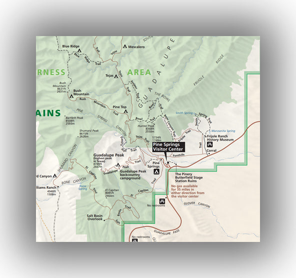
Map of the Pine Springs and Frijole Ranch Areas, courtesy of the National Park Service
The Pine Springs and Frijole Ranch areas are located at the top of the Guadalupe Pass on Highway 62 / 180. This is the heart of the park, with the most activities, hiking and the best place to get any needed information before heading out to explore the park.
When visiting the Pine Springs and Frijole Ranch areas, our recommendations include:
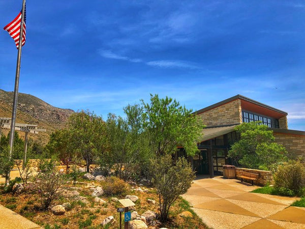
- Pine Springs Visitor Center. While not as large as some of its western counterparts, this is the best and most complete Guadalupe Mountains National Park visitor center. You’ll want to make sure you stop in here for any information you may need about the park. The visitor center is staffed with rangers, and as usual, they were extremely knowledgeable about the park and helped us to understand the best places to visit during our stay. There is also a short video, exhibits about wildlife (which we found quite interesting) and a small gift shop. Be advised that the time zone for Texas is different than New Mexico, meaning that if you are heading to the visitor center you will need to make sure that you don’t mix up the times that it is open!
- Williams Ranch. Williams Ranch is a former cattle, sheep and goat ranch. It was started sometime in the early 1900’s. Not much is known about this secluded land, which is at the base of a 3,000 foot cliff. To access Williams Ranch, you have to get a gate key from the ranger at the Pine Springs Visitor Center. Be advised that to get there you’ll need to travel over a 7-mile dirt road and you should have a high clearance, all-wheel-drive vehicle with rugged tires. Once you are there, you are free to explore the outside area. This is a beautiful spot and isn’t busy at all. The best part about this trip is the journey there, which will take about 3 hours round trip (including time to see the ranch). To learn more about the road, check out the site on Williams Ranch Travel Information.
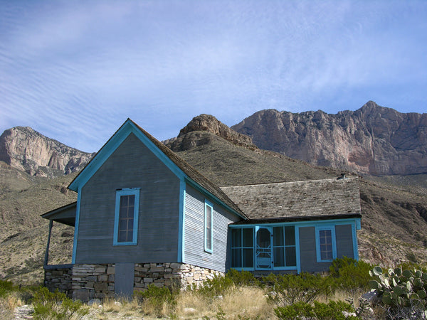
- Frijole Ranch History Museum. Located in the Frijole Ranch Area, this museum shows how ranch life was in the early 1900’s as well as interesting facts about the park. You only need about 30 minutes here, but it is worth a stop if you have the time and are interested in history. During the lighter months of the year this museum is not always open, so make sure you call ahead to the park to check the latest status.
-
Hiking in Guadalupe Mountains National Park is incredible and unlike hiking in other parts of Texas, which is mostly flat. There are several trails in the Pine Springs and Frijole Ranch areas, including two trails that connect the two areas (which are close to each other). We recommend the following trails:
- The Guadalupe Peak Trail is the “headline” trail in the park. It is a challenging 8.1-mile hike and gains over 3,000 feet in elevation. The trailhead starts from the RV section of the Pine Springs campground. After rising quickly in the first 1.5 miles, the trail combines travel through a forest and mountain terrain before reaching the Guadalupe Peak. The views from here are amazing, but be advised that the winds frequently reach over 80 mph, so the weather up here can be completely different than the beginning of the hike!
-
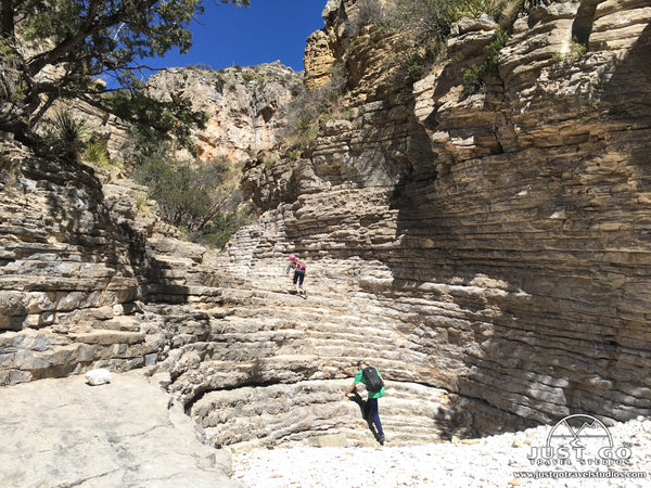
- The Devil’s Hall Trail is a 4.2-mile hike and gains about 680 feet. The trailhead starts at the end of Pine Canyon Drive. The trail heads along the side of a mountain before heading to a wash, which it follows for the last 1.2 miles. There is a final climb at the end to get to the Devil’s Hall. Be careful, as the boulder scrambling in the wash can be tricky over the smooth rocks. At the end, there is a natural staircase that leads to the hall. This is a small crevice with high walls. This hike is really good for families, as the changing landscape and rock scrambling is fun for kids in particular. Our blog post on Devil’s Hall covers details on this really fun hike.
- The Smith Spring Trail is a 2.5-mile loop with about 400 feet of elevation gain. The trailhead is at the Frijole Ranch area. This loop trail is known for wildlife spotting (birds, deer and elk, in particular). After starting off through a canyon, the trail passes through desert landscape before arriving at a small spring. This is another great family hike.
- The Manzanita Spring Trail and the Pinery Trail start from the Frijole Ranch and Pine Springs areas, respectively. These short trails are paved and wheelchair accessible. Both trails combine nature exploration with historical buildings.
- The Bowl Trail combines a trip to the Guadalupe Peak over a distance of 12.5 miles. This is a fantastic, but challenging trail and usually involves overnight camping.
THINGS TO DO IN THE MCKITTRICK CANYON AREA
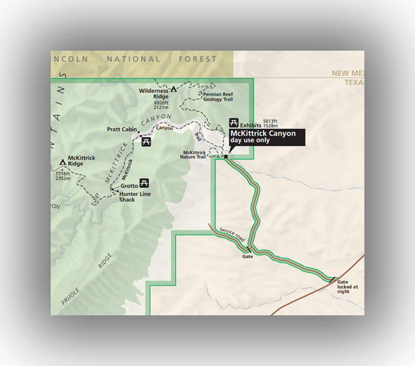
Map of the McKittrick Canyon Area, courtesy of the National Park Service
The McKittrick Canyon is known especially for the incredible fall colors. It is also home to several great hiking trails. The area is only open during the day, so make sure you plan ahead.
While stopping at the McKittrick Canyon area, some of the things to do include:
- McKittrick Canyon Visitor Center. The smaller of the two Guadalupe Mountains National Park visitor centers, this location includes historical information about the area. There isn’t a ton of great things to keep kids entertained here, but there is a video that plays on-demand which may be interesting to them. Still, it’s worth a quick stop if you have the time.
-
Hiking in the McKittrick Canyon area is very good, especially if you are visiting in the fall. There are a few trails that you may want to investigate while you are up here:
- The McKittrick Canyon Trail to the Grotto is a moderately difficult, 6.8-mile hike with just over 500 feet in elevation gain. The trailhead starts at the McKittrick Canyon Visitor Center. This is one of the best rated hikes in the park and traverses over desert, streams, woods and canyons.
I
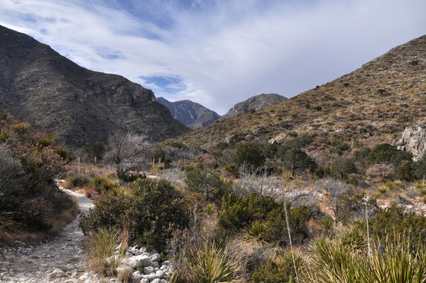
McKittrick Canyon Trail, courtesy of Clinton Steeds
- The Permian Reef Trail is a challenging 8.4-mile hike with over 2,500 feet in elevation gain. This trail travels along the Wilderness Ridge and is great for geology aficionados. Markers along the trail provide information on the park’s geology. This trail is not easy, as you will have to get past some rocky and challenging parts of the trail, but you’ll be rewarded with fantastic views of McKittrick Canyon.
- The McKittrick Canyon Nature Trail is the only short trail in the area, coming in at just under a mile with only 200 feet in elevation gain. This hike will help you get introduced to the local plant life and is great in the spring (when the flowers are in bloom) or in the fall during foliage season.
THINGS TO DO IN THE DOG CANYON AREA
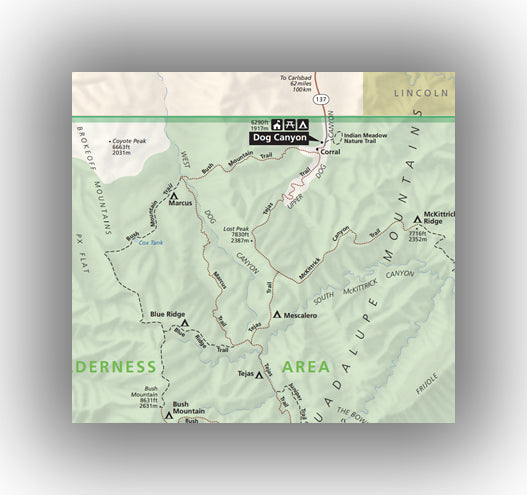
Map of the Dog Canyon Area, courtesy of the National Park Service
The Dog Canyon Area is accessed via Rt. 137 in the northern part of the park. Dog Canyon is secluded but worth visiting. The higher elevations of Dog Canyon bring the temperatures down in the summer.
If you do make it up to Dog Canyon, you can expect to have few people to contend with while you take the time to do the following:
-
Hiking in Guadalupe Mountains National Park is the main event (in case you haven’t noticed it already!) and the Dog Canyon Area has a few trails that are worth checking out. These are the ones that are friendly for families, though check the NPS website for a complete list of trails in the area:
- The Indian Meadow Nature Trail is an easy stroll. At just over 0.6 miles, the trail is flat and teaches about the vegetation and history of the area.
- The Lost Peak (via the Tejas Trail) is a challenging 6.4-mile hike with over 1,500 feet in elevation gain. The trailhead starts at the Dog Canyon Trailhead. The views at the end are great, but be prepared that this is a hard and rocky trail.
THINGS TO DO IN THE SALT BASIN DUNES AREA
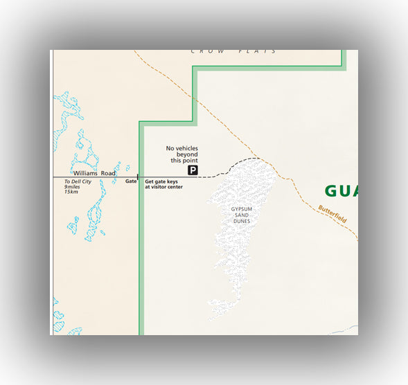
Map of the Salt Basin Dunes Area, courtesy of the National Park Service
The Salt Basin Dunes Area is located on the western end of the park. Expect to walk about 1 mile after you park your car to be able to get to the dunes. Make sure you get supplies in Dell City prior to heading into this remote part of the park. You will also need a key from a ranger at the Pine Springs Visitor Center prior to heading over here. If you plan on heading over here, make sure you go around sunset if you can-it is an amazing place to be, as the light of the sun dances off the mountains with the dunes in the foreground.

WHERE TO STAY IN AND AROUND GUADALUPE MOUNTAINS NATIONAL PARK
- Guadalupe Mountains National Park Lodging: There is no lodging inside of Guadalupe Mountains National Park.
- Lodging near of Guadalupe Mountains National Park: The best place to stay outside the park is in nearby Carlsbad, NM, which is located about one hour from the park to the east.
- Guadalupe Mountains National Park Camping: There are two campgrounds inside the park, one in the Pine Springs Area and one in the Dog Canyon Area. Neither of the two campgrounds accept reservations. You can also camp in the backcountry while hiking.
HOW TO GET TO GUADALUPE MOUNTAINS NATIONAL PARK, WHEN TO GO AND WHAT TO EXPECT
The closest major airport to Guadalupe Mountains National Park is in El Paso, TX. There are plenty of good options for flights by several different carriers. Some carriers only have flights during peak travel times.
Guadalupe Mountains is open year-round, with peak attendance in the wintertime and late fall when the foliage is at its peak.
Guadalupe Mountains National Park weather is cool (by Texas standards). In the winter, temperatures get to around 60 in the daytime, but will be in the 20’s frequently at night. In the summer, temperatures are hot, with the summer months getting to nearly 100 degrees.
The air can be dry, so make sure you bring plenty of water with you!
FURTHER INFORMATION ON GUADALUPE MOUNTAINS NATIONAL PARK FROM JUST GO TRAVEL STUDIOS
- The Devil’s Hall Trail, which is one of the best hikes for families, is covered in detail in our blog: Hiking the Devil’s Hall Trail in Guadalupe Mountains National Park.
- What to do in Guadalupe Mountains National Park, including a ton of information that supplements this blog, is available in our downloadable itinerary for Guadalupe Mountains National Park.
- If you are thinking about camping in Guadalupe Mountains National Park, then be sure to check out our blog on Guadalupe Mountains National Park campgrounds. We cover both campgrounds in detail, as well as provide information on what to do in the area of each campground and what to expect. Don’t forget to check out our blog on the Best Hikes in Guadalupe Mountains National Park!
- We’d love to work with you to take one of your photos and turn them into one of our unique, custom, vintage-style travel posters. If you haven’t tried this yet, we guarantee you won’t be disappointed!

OTHER USEFUL INFORMATION ON GUADALUPE MOUNTAINS NATIONAL PARK AND THE SURROUNDING AREA
- Nearby Carlsbad Caverns National Park is a must-do for anyone who is looking for an amazing experience in cooler weather. Bryanna (from “CrazyFamilyAdventure”) has a great blog post on a 2 day itinerary for visiting the magical Carlsbad Caverns.
- Texas is full of great activities. Check out this resource (from “Texas Outside”) for Fun Things to See and Do in Texas.
- El Paso, TX is just to the west, and Bob Bales (from “thetravellingfool”) has a ton of information on Things to Do in El Paso, TX in his blog.
- The National Park Service has a good amount of information on their site for Guadalupe Mountains National Park.
FINAL THOUGHTS
If you are thinking of heading to the southwest this winter or spring, make sure that Guadalupe Mountains National Park is on your list. You won’t be disappointed, for sure!