11 Best Hikes in Guadalupe Mountains National Park: Trail Maps, Directions & More
Peter Brahan
As you prepare for your trip to Texas, it’s hard to pick the best hike in Guadalupe Mountains National Park. However, whether you have only a few hours and are hiking alone, plan to hike with young children or are here for several days and are ready to conquer some challenging hikes, you are sure to find something that you’ll love!
Some plan to only spend a few hours in the park, but if you can spare a full day or even several, you are surely going to be happy with your decision. Plus, this park is one of the least crowded in the United States, meaning that once you get out on the trail, you are going to really get to experience Texas like few others to.
Yes, it can be a bit challenging to pick the right hike, but we hope that our guide here helps put you in the right direction. After all, there are quite a few to choose from!
HIKING IN GUADALUPE MOUNTAINS NATIONAL PARK: PREPARATION
Like any place you hike, you should be prepared for the unexpected when in the Chihuahuan Desert. However, there are a few extra precautions that we recommend in Guadalupe Mountains National Park specifically:
- Don’t plan on having cell service in the park, so be sure you have some way of navigating (map and/or map and compass).
- Above all, it can be hot and dry here, even in the winter months. Carry more water than you think you will need, and protect yourself from the sun with glasses, a hat and sunblock. There is little shade on the trail as well!
- The rocks in the area are pretty sharp, and slips and falls are common. A small first aid kit is a great idea, particularly if you are hiking with families.
GUADALUPE MOUNTAINS NATIONAL PARK HIKING: DISTANCES AND ELEVATION GAIN
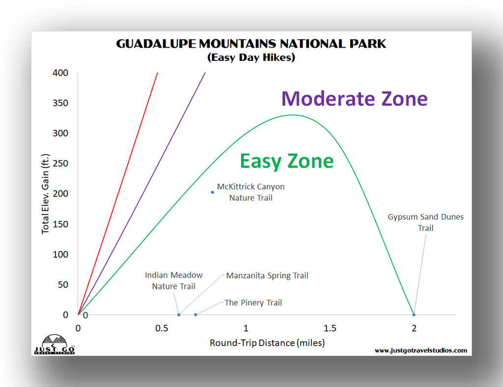
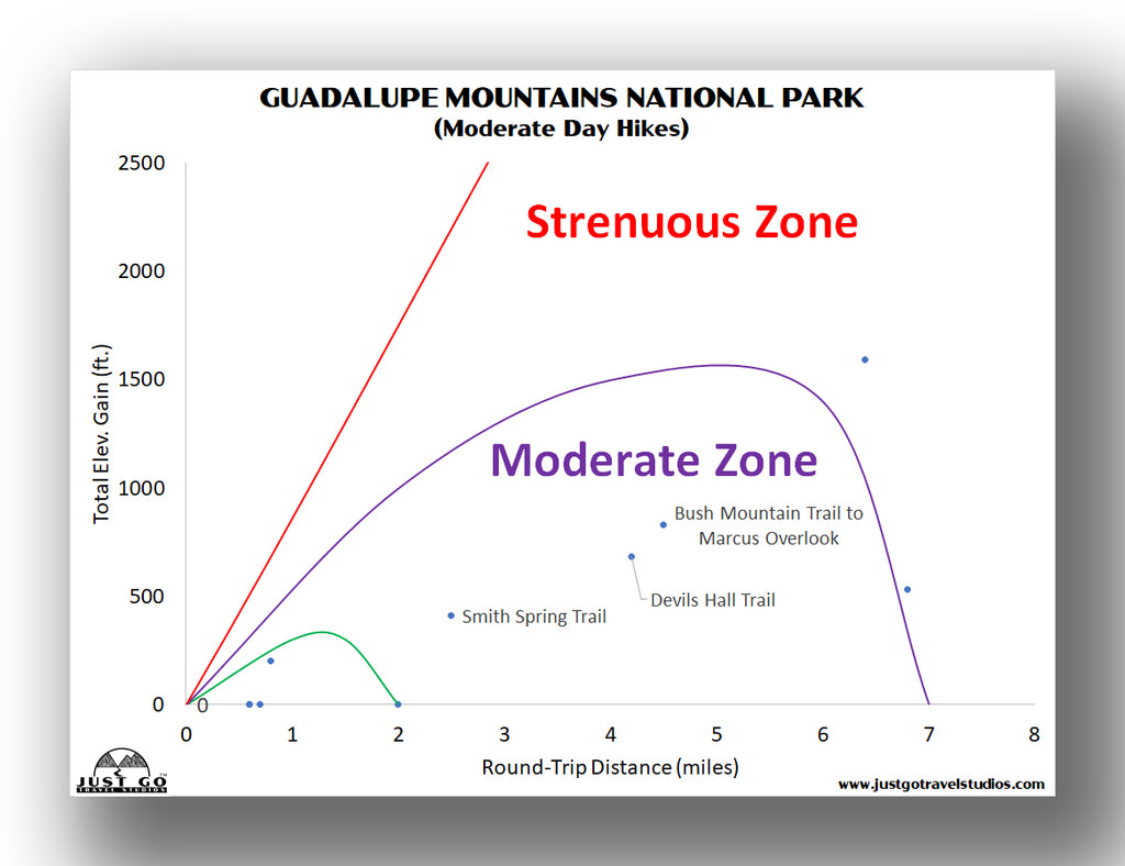
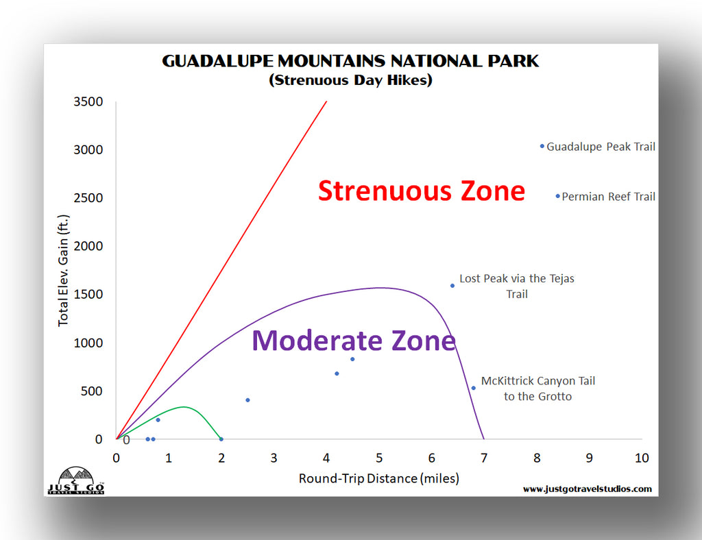
The more you look into hiking in Guadalupe Mountains National Park, the more options you’ll find and it can be a bit intimidating to pick the best hike! To help you with your hike selection, we’ve created a few charts to make it a bit easier.
If you are looking to pick a hike that will only take about an hour and is relatively easy, this chart will give you an idea of some great hikes to pick.
For a moderately challenging hike, there are a few options listed in the chart below.
Finally, there is a decent selection of more challenging hikes that most consider to be strenuous, either due to the length, elevation gain or both.
Our Guadalupe Mountains National Park Itinerary helps you plan your trip to this amazing park. We cover the hikes from this blog in detail, as well as additional hikes, what to pack, where to stay and what to see and do in the area.
BEST HIKES IN GUADALUPE MOUNTAINS NATIONAL PARK: TRAIL DESCRIPTIONS AND TRAIL MAPS
GUADALUPE PEAK TRAIL
- Difficulty: Hard
- Distance (round-trip): 8.0 miles
- Elevation gain: 3050 feet
- Hiking time (approximate): 6 to 8 hours
- Trail type: Out-and-back
- Potential hazards: Sun exposure, rocky surfaces can scrape skin
- Restrooms: Restrooms are located at the trailhead in the parking lot. No restrooms are located along the trail.
- Recommended footwear: Hiking boots.
- Pets: Not allowed
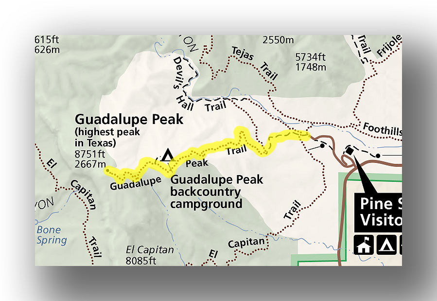
Guadalupe Peak Trail map, courtesy of the National Park Service
Trail Description
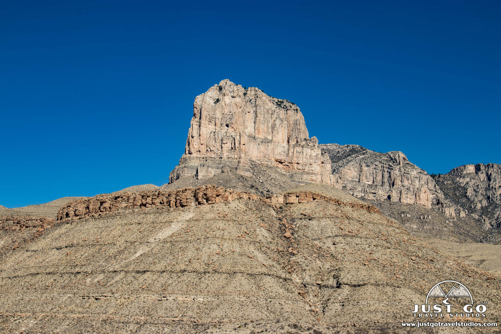
Many visitors come to Guadalupe Mountains National Park with the sole purpose of conquering Guadalupe Peak. This challenging trail is just over 8 miles long (round-trip) and climbs a total just over 3000 feet on the way up to the highest point in the state of Texas.
After leaving the RV parking area, the trail starts off with a very steep, 1.5-mile climb, aided by switchbacks. The trail passes through a forest on the way up to Guadalupe Peak. Amazingly enough, the trail is in the shade for a good part of the hike, as it’s on the north slope of the mountain, and benefits from the tall pines which help block the sunlight.
As you begin the final push to the peak, you’ll have incredible views which just keep on getting better. At the peak, you’ll be able to see for many miles, including the nearby desert as well as the mountains. Beware that the hike is challenging, and when you get to the top it’s common for there to be very high winds, which can top 80 mph. The winds are especially high in the spring.
Guadalupe Peak Trail Highlights
- Sense of Accomplishment: When you climb this peak, you’ll have climbed the highest peak in all of the state of Texas! That is certainly something to be proud of.
- Amazing Panoramic Views: Seeing as though this is the highest peak in the state, you’ll have incredible views from the top (assuming the weather is good!).
Guadalupe Peak Trail Challenges
- Strenuous: The hike is very demanding. Even though the trail is well marked and maintained, you are undoubtedly doing to be tired at the end of it.
- Harsh Weather: The weather can be super harsh on the top of the peak, and it can be a bit surprising and sneak up on you. Just look at the weather forecast ahead of time.
Trailhead Directions
The trailhead is located at the RV portion of the Pine Springs Campground, close to the Pine Springs Visitor Center. You can also hike from the Visitor Center, but that adds about 2 miles (round-trip) onto the hike.
DEVILS HALL TRAIL
- Difficulty: Moderate / Hard
- Distance (round-trip): 4.2 miles
- Elevation gain: 680 feet
- Hiking time (approximate): 2 to 3 hours
- Trail type: Out-and-back
- Potential hazards: Cuts and scrapes from rocks, falling near Devils Hall
- Restrooms: Restrooms are located at the trailhead in the parking lot. No restrooms are located along the trail.
- Recommended footwear: Hiking boots or hiking shoes.
- Pets: Not allowed

Devils Hall Trail map, courtesy of the National Park Service
Trail Description
If you are in the mood for something challenging but with less elevation gain and a bit shorter, then the Devils Hall Trail may be the perfect one for you. This 4.2-mile (round-trip) trail only has about 680 feet elevation gain, and we promise it’ll be one of the most unique hikes that you do!
For the first mile, the trail heads along the side of a mountain before heading to a wash. The trail then follows the dry wash for the last 1.2 miles before the final climb. As you head through the wash, you’ll be climbing over a few small boulders, and honestly it won’t even feel like you are gaining in elevation. Be careful, as the boulder scrambling, while not technical, can be tricky over the smooth rocks.
The natural staircase at the end is very short but steep. After the staircase, the trail ends in the hall, which is a small crevice with high walls. On the way back, be especially careful climbing back down the staircase. Note: even if you don’t climb the staircase at the end, the trail is still worth it. This hike is really good for families, as the changing landscape and rock scrambling is fun for kids in particular.
Devils Hall Trail Highlights
- Unique Rock Formations: The narrow canyon and the “hallway” at the end forms a natural corridor which is very unique!
- Diverse Terrain: The hike on the way into the hall is on a hillside before descending into a wash, which involves rocks and a variety of terrain. It certainly makes the hike interesting!
Devils Hall Trail Challenges
- Uneven Trail: The trail is not on even terrain and can be quite challenging to navigate if you are not sure on your feet. We recommend hiking poles if you need the for balance.
- Crowds: This hike can be busy, since it’s close to the Visitor Center and doesn’t involve much in the way of elevation gain.
Trailhead Directions
The trailhead is located at the end of Pine Canyon drive at the RV portion of the Pine Springs Campground, close to the Pine Springs Visitor Center.

SMITH SPRING AND MANZANITA SPRING LOOP TRAIL
- Difficulty: Easy / Moderate
- Distance (round-trip): 2.5 miles
- Elevation gain: 400 feet
- Hiking time (approximate): 1.5 hours
- Trail type: Loop
- Potential hazards: Sun exposure, rocky surfaces can scrape skin, bugs
- Restrooms: Restrooms are located at the trailhead.
- Recommended footwear: Hiking shoes.
- Pets: Not allowed

Trail Description
It’s not overly common to come across water while you are out hiking in Texas, which makes the Smith Spring and Manzanita Spring Loop so special. This 2.5-mile loop (round-trip) only climbs about 400 feet and heads to two springs.
As you leave the parking lot you’ll immediately come to a fork. If you want to head up the steepest portion of the hike (rather than coming down it), head right (counter-clockwise). The trail is flat (and wheelchair accessible) up to about the 0.3-mile point where you’ll reach the Manzanita Spring.
After the first spring, the trail heads uphill slowly and increases in incline as you approach Smith Spring. Along the trail you’ll have the opportunity to see plenty of wildflowers. You may also catch a glimpse of some wildlife (birds, deer and elk in particular). This hike combines a canyon with the desert and beautiful colors with the flowers, so it’s great to take on with the family in particular!
Keep an eye out for trail signs as you head on the western side of the loop, back down the grade to the parking area.
Smith Spring Trail Highlights
- Wildlife Viewing: In addition to the scenery on this hike, you also have the opportunity to see wildlife, like deer and birds.
- Moderate: Many of the longer trails in the park are quite challenging, so this has a good sweet spot of not being a nature walk, but long enough to feel like you accomplished something.
Smith Spring Trail Challenges
- Exposure: The trail is exposed, so just be aware that you will need sun protection.
- Bugs: Since this hike involves water, you can encounter bugs on the trail and may want to bring bug spray.
Trailhead Directions
The trailhead starts at the Frijole Ranch Trailhead.
Hike Option: you can just hike to Manzanita Spring, which is only about 0.6 miles (round-trip). This is the most crowded part of the trail.
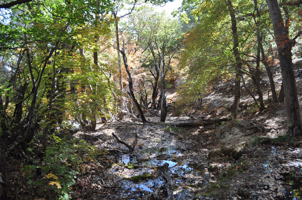
Smith Spring Trail, image courtesy of Fredlyfish4
MCKITTRICK CANYON TRAIL TO THE GROTTO / HUNTER LINE SHACK
- Difficulty: Moderate
- Distance (round-trip): 6.8 miles
- Elevation gain: 500 feet
- Hiking time (approximate): 3 to 4 hours
- Trail type: Out-and-back
- Potential hazards: Sun exposure
- Restrooms: No restrooms are located at McKittrick Canyon. We recommend using them at the visitor center in Pine Sprints first.
- Recommended footwear: Hiking boots.
- Pets: Not allowed
Trail Description
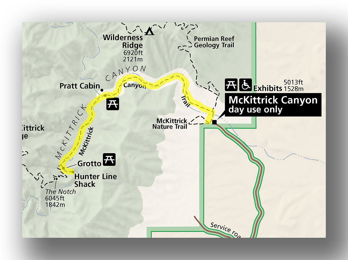
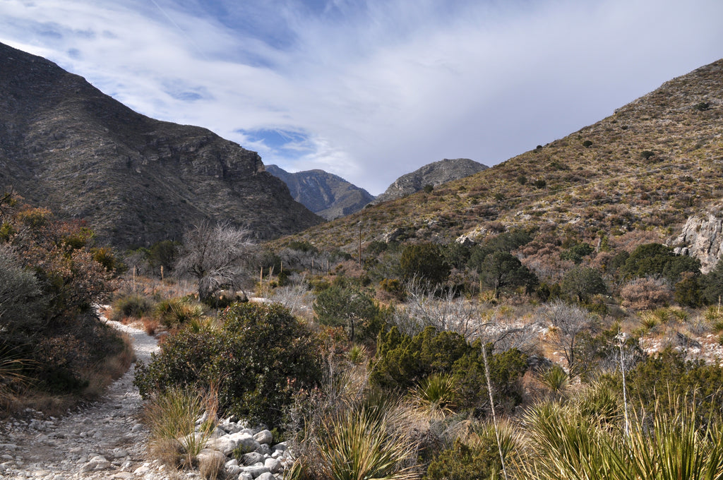
Though McKittrick Canyon isn’t as remote as Dog Canyon, it does take a bit of time to get to. Still, the hikes here are quite good, and the McKittrick Canyon Trail to the Grotto is a good choice! This moderate, 6.8-mile (round-trip) hike leaves the parking area and heads northwest through a wash.
Along the way, the trail ascends slowly but steadily with a total elevation gain of just over 500 feet. Halfway along the trail is Pratt Cabin, which is worth checking out. You’ll end the hike at the Hunter Line Shack, which is just past the Grotto. Here you can eat on the picnic tables with a great view. The views start off not terrific on the hike, but get better and better as you travel along the trail!
McKittrick Canyon Trail Highlights
- Diverse Landscape: This hike contains woodlands, lush foliage and the picturesque Grotto area with unique rock formations.
- Educational: The trail includes interpretive signs about the area’s natural history.
McKittrick Canyon Trail Challenges
- Limited Hours: Access to the trailhead has limited hours, so be sure to check in with the Ranger ahead of your visit to confirm when you can start and when you have to end the hike.
- Exposure: You will be out in the hot sun for most of the hike, so just be prepared.
Trailhead Directions
The trailhead starts at the McKittrick Canyon Visitor Center.
Hike option: Just head to Pratt Cabin, and this will make the trail a total of 4.8 miles round trip, with only 340 feet of elevation gain.
McKittrick Canyon Trail, image courtesy of Clinton Steeds
THE PINERY
- Difficulty: Easy
- Distance (round-trip): 0.7 miles
- Elevation gain: Minimal
- Hiking time (approximate): 30 minutes
- Trail type: Out-and-back
- Potential hazards: Sun exposure
- Restrooms: Restrooms are located at the trailhead.
- Recommended footwear: Closed-toed shoes
- Pets: Not allowed
The Pinery Trail map, courtesy of the National Park Service
Trail Description
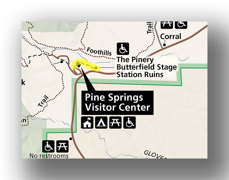
Located near the main visitor center, the Pinery Trail is an easy, 0.7-mile (round-trip) hike that has minimal elevation gain. This trail heads due-east from the Pine Springs Visitor Center and is paved.
Along the way, you’ll get a chance to learn about the history of the area. The trail ends at the Butterfield Stage Coach station, built in 1859.
The Pinery Trail Highlights
- Historical Significance: Learning about the Pinery Station and how the area was used before is quite interesting!
- Convenient: The trail is located right near the Visitor Center, so it’s easy to get to.
The Pinery Trail Challenges
- Short: The trail is super quick to hike, so if you are looking for something longer, you may be disappointed.
- Crowded: Since this is right near the Visitor Center, the trail is typically pretty busy
Trailhead Directions
The trailhead for the Pinery Trail is just behind the Pine Springs Visitor Center.
PERMIAN REEF TRAIL
- Difficulty: Hard
- Distance (round-trip): 8.4 miles
- Elevation gain: 2520 feet
- Hiking time (approximate): 5 hours
- Trail type: Out-and-back
- Potential hazards: Sun exposure, rocky surfaces can scrape skin
- Restrooms: No restrooms are located at the trailhead or along the trail.
- Recommended footwear: Hiking boots.
- Pets: Not allowed
Permian Reef Trail map, courtesy of the National Park Service
Trail Description
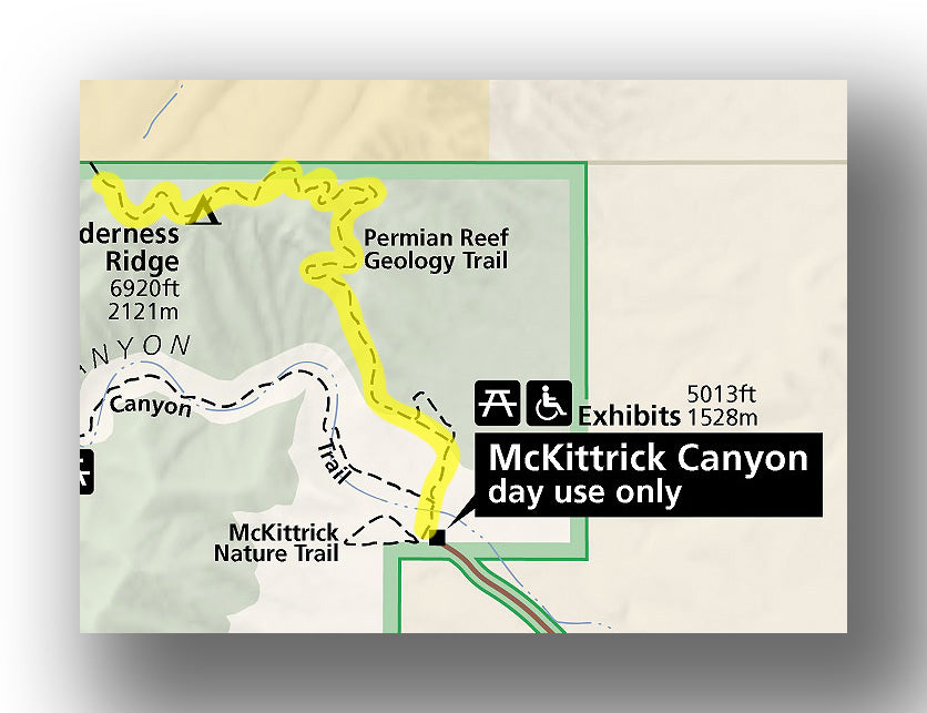
One of the lesser used trails in the park (but still amazing) is the Permian Reef Trail. This 8.4-mile (round-trip) hike gains 2520 feet in elevation.
After departing the day-use area, the trail heads to the north and provides information about geology as you climb the bulk of the elevation gain in the first 3.0 miles of the hike. There are some rocky parts of the hike that make it challenging, and you can count on there being some cactus along the way that is going to brush up against your legs if they are exposed (so wear long pants!).
Hikers that make it the entire way will be rewarded with amazing views of McKittrick Canyon! The official park trail ends at the border with the Lincoln National Forest, but you can keep heading into the forest if desired.
Permian Reef Trail Highlights
- Spectacular Views: You’ll love the views of McKittrick Canyon and the surrounding desert landscape.
- Well-maintained: The trail is really well maintained with clear signage.
Permian Reef Trail Challenges
- Challenging: The trail is long with a good amount of elevation gain, so you need to be prepared for it to take the better part of a day.
Trailhead Directions
The trailhead for the Permian Reef Trail starts at the McKittrick Canyon Visitor Center.
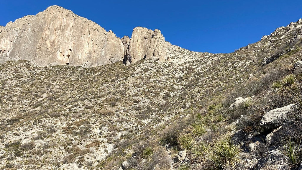
Permian Reef Trail, courtesy of the National Park Service
MCKITTRICK CANYON NATURE TRAIL
- Difficulty: Easy
- Distance (round-trip): 0.8 miles
- Elevation gain: 203 feet
- Hiking time (approximate): 45 minutes
- Trail type: Loop
- Potential hazards: Sun exposure
- Restrooms: Restrooms are located at the trailhead.
- Recommended footwear: Closed-toed shoes or sturdy sandals.
- Pets: Not allowed
Trail Description
The McKittrick Canyon Nature Trail is an easy loop that travels near the head of the canyon. Along the way you’ll see a variety of animals (and potentially animals!) as you learn about the geology of the area. It’s short, but this is great for kids in particular as the learning will keep both children and adults engaged.
McKittrick Canyon Nature Trail Highlights
- Beautiful Scenery: On this short trail you’ll travel through a variety of landscapes. The colors in the fall are particularly spectacular.
- Educational Value: The interpretive signs along the way are really well done, and you’ll come here having learned a bit about the area.
McKittrick Canyon Nature Trail Challenges
- Sun-Exposure: This trail is downright hot in the sun, even though it is short. Come prepared with a hat, sunglasses and sunblock.
- Crowds: Since the trail is so accessible (both for hikers of all skill levels and close to the road), it draws plenty of visitors. Be prepared to have company on the hike!
Trailhead Directions
The McKittrick Canyon Nature Trail begins at the McKittrick Canyon Visitor Center.
INDIAN MEADOW NATURE TRAIL
- Difficulty: Easy
- Distance (round-trip): 0.6 miles
- Elevation gain: Minimal
- Hiking time (approximate): 30 minutes
- Trail type: Loop
- Potential hazards: Sun exposure
- Restrooms: Restrooms are located at the trailhead.
- Recommended footwear: Closed-toed shoes or sturdy sandals.
- Pets: Not allowed

Indian Meadow Nature Trail map, courtesy of the National Park Service
Trail Description
You’ll start by heading east from the trailhead before reaching a junction where you can turn left or right to go around the loop. If you pick up a guide at the start of the trail, you can learn about the vegetation and history of the area.
This is a short trail, but great for families or if you are camping and need to stretch your legs in the evening.
Indian Meadow Nature Trail Highlights
- Flat: Unlike many of the trails in Guadalupe Mountains National Park, this hike is relatively flat. Some like to use it as a running trail.
- Wildlife Viewing: There is a good chance that you’ll see wildlife here. There is an overlook to an open grassland area, which makes it particularly good for viewing without having to walk too far. We recommend coming in the early morning or evening for the best chance of spotting animals.
Indian Meadow Nature Trail Challenges
- Short: This is a short trail and may have you wanting more!
Trailhead Directions
The trailhead starts at the Dog Canyon trailhead in the northern part of the park.

Indian Meadow Nature Trail, courtesy of the National Park Service
LOST PEAK VIA THE TEJAS TRAIL
- Difficulty: Hard
- Distance (round-trip): 6.4 miles
- Elevation gain: 1592 feet
- Hiking time (approximate): 4 hours
- Trail type: Out-and-back
- Potential hazards: Sun exposure, sharp rocks, uneven terrain, thorns in the vegetation
- Restrooms: Restrooms are located at the trailhead.
- Recommended footwear: Hiking boots
- Pets: Not allowed

Lost Peak via the Tejas Trail map, courtesy of the National Park Service
Trail Description
The Tejas Trail starts off from the Dog Canyon Campground area. The trail heads south through the Dog Canyon, which is quite beautiful. Pretty much right after you start hiking you’ll head uphill, and that doesn’t end until you get to the peak. The trail gets steeper as you approach the peak, but only slightly.
The views from Lost Peak are incredible. You do have to go about 100 feet off trail to see the panoramic views, but it’s highly recommended to do so.
Wearing long pants on this hike is recommended if it’s not too hot, as the thorns in the plants can be pretty rough if one catches you.
Lost Peak via the Tejas Trail Highlights
- Incredible Scenery: The views from the peak are amazing.
- Diverse Landscape: This hike combines climbing to a peak with hiking through Dog Canyon. The change of landscape is not common to most hikes, so this is a nice change.
Lost Peak via the Tejas Trail Challenges
- Steep and Relentless: Many may find this hike to be long-the uphill isn’t too steep, but it doesn’t stop and there are no breaks.
Trailhead Directions
The trailhead starts at the Dog Canyon trailhead in the northern part of the park.

Tejas Trail, courtesy of the National Park Service
BUSH MOUNTAIN TRAIL TO MARCUS OVERLOOK
- Difficulty: Moderate
- Distance (round-trip): 4.5 miles
- Elevation gain: 830 feet
- Hiking time (approximate): 2 to 3 hours
- Trail type: Out-and-back
- Potential hazards: Sun exposure, jagged rocks, thorny vegetation
- Restrooms: Restrooms are located at the trailhead.
- Recommended footwear: Hiking shoes or hiking boots.
- Pets: Not allowed

Bush Mountain Trail to Marcus Overlook map, courtesy of the National Park Service
Trail Description
Start by leaving the trailhead and heading west. The hike starts to gain in elevation slowly and steadily, and this continues on all the way to the overlook at the 2.2-mile point. Continue hiking on the Bush Mountain Trail until it levels out. From the Marcus Overlook, you’ll have views into West Dog Canyon.
The Bush Mountain Trail goes on for many miles, and some use this as a backpacking route. However, unless you are equipped to do that, we recommend turning around here and heading back to the trailhead.
Bush Mountain Trail Highlights
- Uncrowded: This trail is one of the least popular hikes in the park. This is because of the remoteness of Dog Canyon and also most others opt for hiking the Tejas Trail. This means that you’ll have peace and quiet during your hike!
- Unique Views: This hike gets you a good look into West Dog Canyon, which is quite spectacular and quite different from the panoramic views that most seek.
Bush Mountain Trail Challenges
- Demanding: This trail isn’t as hard as the Tejas Trail, but just be aware that it still is demanding, particularly if you go during the heat of summer.
Trailhead Directions
The trailhead starts at the Dog Canyon trailhead in the northern part of the park.

Marcus Overlook, courtesy of the National Park Service
GYPSUM SAND DUNES TRAIL
- Difficulty: Easy
- Distance (round-trip): 2.0 miles
- Elevation gain: Minimal
- Hiking time (approximate): 1 hour
- Trail type: Out-and-back
- Potential hazards: Sun exposure
- Restrooms: Restrooms are located at the trailhead.
- Recommended footwear: Sandals or shoes.
- Pets: Not allowed
Trail Description
To hike the Gypsum Sand Dunes, just head east from the parking area. You’ll get great views of the sand dunes. You can hike where you want-there are marked trails, but you can also explore around the dunes.
This area is particularly nice around sunset.
Gypsum Sand Dunes Trail Highlights
- Amazing Photography: If you head here around the “golden hour” (an hour or so before sunset), you will be able to take some incredible photos.
- Lack of Crowds: There typically are not many people here, so you will likely get a very quiet and serene experience.
Gypsum Sand Dunes Trail Challenges
- Sun-Exposure: The trail is on sand dunes, so expect to be in the sun the entire time!
- Time Consuming: It takes a bit of time to get to the trail since it is in a remote part of the park, and some may not think it’s worth it. We recommend it if you are visiting the park for more than a day.
Trailhead Directions
The Gypsum Sand Dunes Trail begins at the parking area at the end of Williams Road in the western side of the park. Take Highway 180 west until you take a right (north) on Route 1576. Continue until you see
THE BEST FAMILY-FRIENDLY HIKES IN GUADALUPE MOUNTAINS NATIONAL PARK
Guadalupe Mountains National Park is great for hiking with families. A few trails that we recommend include:
- The Pinery (short, paved hike to learn about the history with a Stage Coach Station)
- McKittrick Canyon Nature Trail (short hike with information about the geology of the areas and good potential for animal sightings)
- Indian Meadow Nature Trail (a short hike with information about the vegetation and history)
- Devils Hall Trail (it can be considered to be a bit on the challenging side, but the elevation gain is slight and it’s really neat to walk through the wash-you can also cut the hike short and still get great scenery!)
ARE PETS ALLOWED ON THE TRAILS AT GUADALUPE MOUNTAINS NATIONAL PARK?
Pets are not allowed on any of the trails in Guadalupe Mountains National Park
WHEN IS THE BEST TIME OF YEAR TO HIKE AT GUADALUPE MOUNTAINS NATIONAL PARK?
Temperatures in Guadalupe Mountains National Park can soar to over 100 degrees F in the summer, but also well below freezing in the winter. Therefore, we highly recommend hiking in spring and fall. Specifically, March through early May is spectacular, and the fall is quite nice too. Once you get to November through February, you really need to bring plenty of layers to protect yourself from the cold, particularly if you plan on hiking Guadalupe Peak where the winds can be fierce.
GUADALUPE MOUNTAINS NATIONAL PARK HIKING PERMITS
If you plan on hiking and staying overnight in the park, then you need to obtain a permit. You can read about the Guadalupe Mountains Wilderness Use Permit here.
FURTHER INFORMATION ON GUADALUPE MOUNTAINS NATIONAL PARK FROM JUST GO TRAVEL STUDIOS
- Before you head out on your trip, we recommend grabbing a copy of our Guadalupe Mountains National Park itinerary to help you out with your planning!
- Other blogs that we have on Guadalupe Mountains include What to See and Do in Guadalupe Mountains, Hiking the Devils Hall Trail and Camping in Guadalupe Mountains.
- After your vacation, get one of our custom, vintage-style posters that we make from you own photo!
