
7 Best Hikes in Big Bend National Park: Trail Maps, Directions & More
Peter BrahanWhile it takes a bit of work to get to the southwestern side of Texas, the wonderful hiking adventures that await you in Big Bend National Park are well worth the trip. In all of our travels, it amazes us how few National Park lovers make their way down to this part of the country. In fact, many people put visiting the Texas National Parks off until later on in their lives, when hiking in Big Bend National Park is beyond their capability or interest.
For those that do make their way to this amazing (and surprising country), you won’t be disappointed with your stay at all! From day-long hikes with plenty of elevation gain to fairly easy jaunts that will take under an hour, this park is great to visit and explore on foot.
While there are over 2 dozen great hikes to do, we decided to put together a few of what we considered to be the best hikes in Big Bend National Park to save you a bit of time. Please leave a note in the comments section below if you have anything to add or any questions-we usually respond within a day on the site and also personally via email.
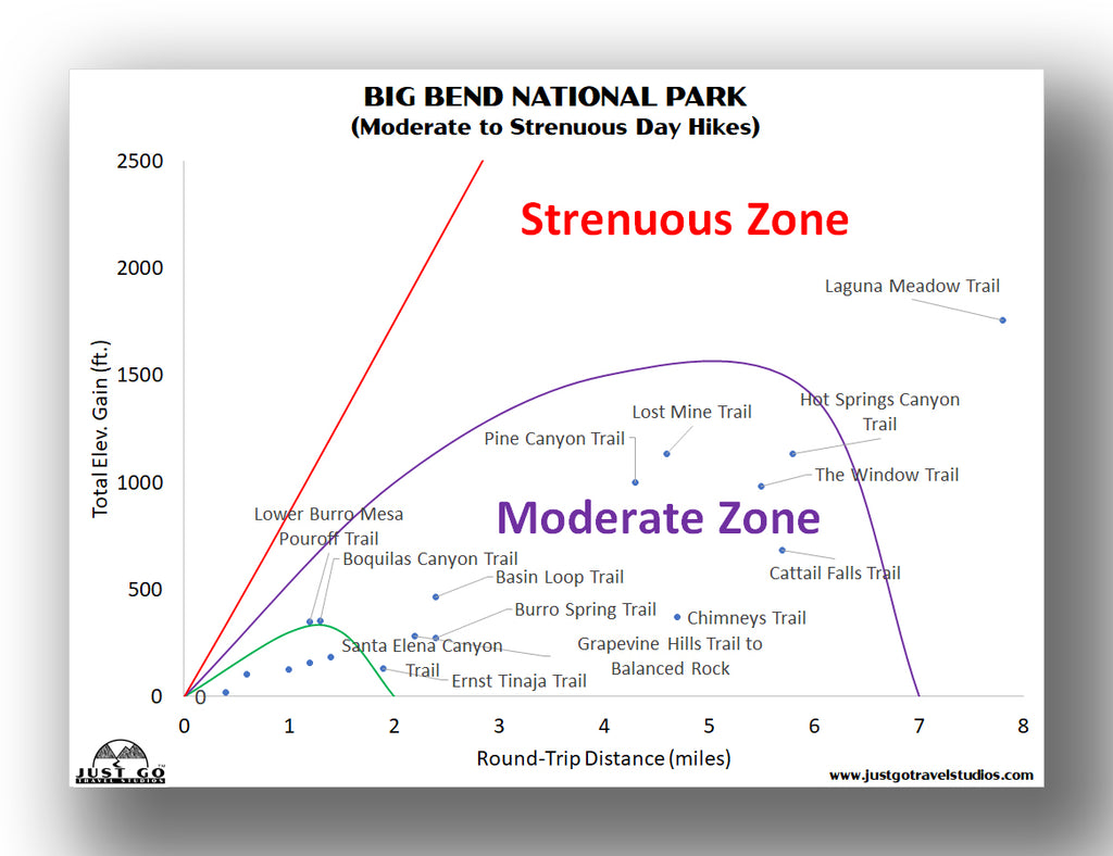
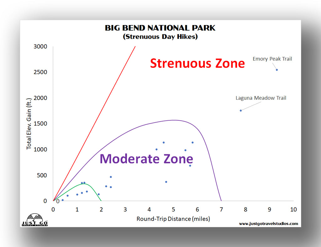
BIG BEND NATIONAL PARK HIKING: DISTANCES AND ELEVATION GAIN
When you are visiting Big Bend National Park, there are a ton of hiking options that you may want to consider. While this blog covers what we think are the very best hikes, there are other hikes for you as well!
If you are looking for some easy hikes, there are a few to choose from:
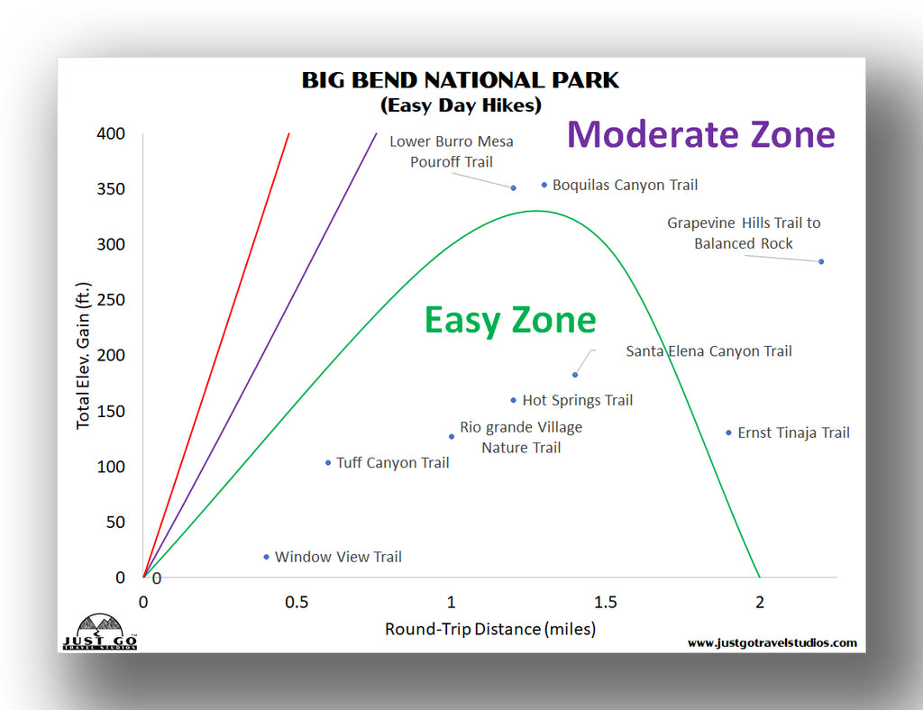
Of course, if you have the ability to get out on some more intense trails, there are many options, and even some that will keep you busy for the better part of the day.

Before you head out on your journey, be sure to download a copy of our Big Bend National Park Itinerary to help shortcut your trip planning. We include details on hiking, what to pack, what to do ahead of your trip, where to stay and what to see while you are in the park and the surrounding area.
BEST HIKES IN BIG BEND NATIONAL PARK: TRAIL DESCRIPTIONS AND TRAIL MAPS
LOST MINE TRAIL
- Difficulty: Moderate
- Distance (round-trip): 4.8 miles
- Elevation gain: 1040 feet
- Hiking time (approximate): 2 to 3 hours

Lost Mine Trail map, courtesy of the National Park Service
Our favorite hike during our visit to Big Bend National Park was the Lost Mine Trail. This hike is relatively short but has incredible views into the Juniper Canyon, particularly in the latter part of the day when the sun is at your back.
The hike on the Lost Mine Trail is approximately 4.8 miles and rated as moderate. The elevation gain is just over 1000 feet, but there are never any steep parts of the trail and even our young kids thought the hike was relatively easy as compared to most of the National Park hikes that we’ve done.
The trail starts to climb continuously right from the start until it levels off before the end of the trail on the long and rocky overlook area. Not only are the views from the top amazing, there also great sights along the way, with the best stop being an overlook about halfway up to the top of the trail.
The last 0.2-miles of the trail is relatively flat as it continues along the open ridge. From there the views are incredible-we actually thought the views from this trail were the best we saw in the entire park. The ridge at the top is large and very expansive (this is an understatement!) and there are plenty of places to sit and relax and have a snack before returning.
This is one Big Bend hiking trail that you don’t want to miss!
The Lost Mine Trailhead is located about 1.2 miles northeast of the Chisos Basin Visitor Center.

Hiking the Lost Mine Trail in Big Bend National Park
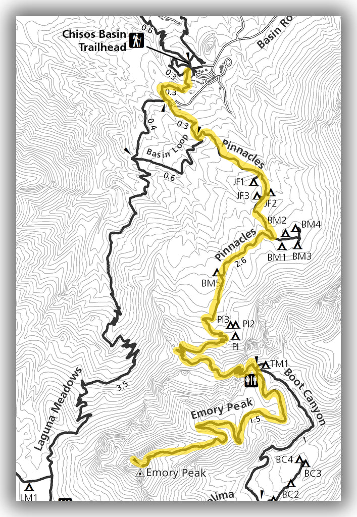
EMORY PEAK TRAIL
- Difficulty: Hard
- Distance (round-trip): 9.3 miles
- Elevation gain: 2400 feet
- Hiking time (approximate): 5 to 6 hours
Emory Peak Trail map, courtesy of the National Park Service
The Emory Peak Trail is known for being the most intense hike in Big Bend National Park. While the views from the top are indeed amazing, you’ll have to work to get there, particularly in the latter part of the hike.
The hike to Emory Peak is a 9.3-mile (round trip) hike rated as difficult. The elevation gain is just over 2500 feet.
After starting on the Windows Trail, the trail diverges at the 0.2-mile point to travel on the Pinnacles Trail. The time on the Windows Trail is really the only easy part of the hike, as it starts to climb (and doesn’t let up) as it continues on the Pinnacles Trail for the rest of the hike. This trail continues for the remainder of the hike. There are small switchbacks along the way to help, but it really is an uphill climb the entire way.
The trail is shaded for the first part of the hike, but is exposed for about 70% of the hike, so be prepared with sunblock, a hat and plenty of water.
The last 100 feet of climbing requires rock scrambling to get to the top and be warned that some turn around without going up the last bit due to fear of heights.
At the top, you’ll be able to see a great view that extends into Mexico as well as a great view of the Chisos Basin.

A view from the top of Emory Peak
The trailhead for the Emory Peak Trail is actually the same as the Window Trail and is located aside of the convenience store in near the Chisos Basin Lodge.
WINDOW TRAIL
- Difficulty: Moderate
- Distance (round-trip): 5.5 miles
- Elevation gain: 980 feet
- Hiking time (approximate): 3 hours
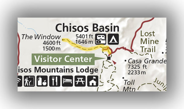
The Window Trail map, courtesy of the National Park Service
The Window Trail leads hikers through the Chisos Basin down to an interesting view through “the Window”, which is essentially a water pour-off that creates a really unique view of the park.
This moderately difficult trail is 5.5-miles long (round trip) and descends nearly 1000 feet on the way to the pour-off.
The trail starts off relatively flat for the first 0.2 miles and is in the open. Afterwards, the trail starts to descend and at 0.7 miles you’ll enter a grove of trees. This grove is a welcome opportunity for shade (especially on the way back when you are climbing back up) and actually is also a great spot for spotting some of the birds that are native to this part of Texas.
As the trail reaches the end, the dirt path transitions to hiking on rocks that have been worn down and smoothed due to erosion over time. Keep a close eye on your kids in this area and watch your footing.
The view from the Windows is small, but it is really interesting to see. Be sure to keep your family close by, as if you venture too far the opening does go to a steep drop-off. At no time did we feel unsafe, but it is something to be mindful of as you reach the end.
Be prepared for the heat on this trail. Since much of it is exposed and the hike back to your car is uphill, it can be a bit challenging on the return trip in particular, even though you may have run down the trail (like our kids did!).
The trailhead for the Window Trail is located aside the convenience store in the Chisos Basin Lodge area.
Hike option: Cut off 1.9 miles and 500 feet of elevation gain from the trail by hiking from the Chisos Basin Campground area. Parking is limited here, but we recommend doing this to allow for more time in other parts of the park.

Hiking the Window Trail in Big Bend National Park
HOT SPRINGS TRAIL
- Difficulty: Easy
- Distance (round-trip): 1.2 miles
- Elevation gain: 150 feet
- Hiking time (approximate): 30 to 45 minutes

Hot Springs Trail map, courtesy of the National Park Service
The Hot Springs Trail is in the Rio Grande Village part of the park. This area is a bit out of the way if you are staying in the Chisos Basin area, but is worth the day-trip if you have the time. It is also where river trips originate.
The Hot Springs Trail is an easy 1.2-mile loop that climbs only about 150 feet. The trail follows the Rio Grande River before ending at the Hot Springs. This can be a great place to relax if you have been hiking all day.
The trailhead is located at the end of the dirt road leading to Hot Springs. Be sure to check on road conditions ahead of driving here, as it can be a bit rough for larger vehicles in particular.
Hike option: Another way of reaching the Hot Springs is by taking the Hot Springs Canyon Trail. This is a 5.8-mile (round-trip) hike that starts at Daniels Ranch on the west side of the Rio Grande Village. This trail heads along the Rio Grande River, has great views along the way and climbs a bit over 1100 feet. It is also fully exposed, so be prepared if you hike here in the heat of the day.

Hot Springs Trail, courtesy of JRick1
GRAPEVINE HILLS TRAIL TO BALANCED ROCK (BALANCED ROCK TRAIL)
- Difficulty: Easy / Moderate
- Distance (round-trip): 2.2 miles
- Elevation gain: 230 feet
- Hiking time (approximate): 1 to 1.5 hours
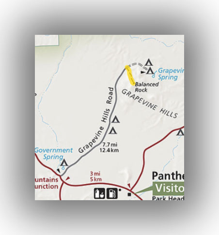
Grapevine Hills Trail map, courtesy of the National Park Service
The Grapevine Hills Trail is another great hike that is just north of the Chisos Basin area of the park. This trail leads to unique rock formation and is one of the most photographed spots in Big Bend National Park.
This 2.2-mile (round-trip) hike is easy-moderate, and only gains about 230 feet (most of which is at the end of the hike). To really see the rocks it does require a bit of scrambling at the end, so just be advised that it isn’t entirely flat.
The trail starts by heading down a sandy wash that is bordered on each side by large boulders. The rock formation at the end is very unique and worth checking out.
The trailhead is located at the end of Grapevine Spring Road, which is a 7-mile dirt road. Check with rangers for road conditions if there is a risk of washouts or rough spots.

Balanced Rock, courtesy of Sefor4
SANTA ELENA CANYON TRAIL
- Difficulty: Easy / Moderate
- Distance (round-trip): 1.4 miles
- Elevation gain: 200 feet
- Hiking time (approximate): 1 hour

Santa Elena Canyon Trail map, courtesy of the National Park Service
The Santa Elena Canyon Trail is one of the best trails in the park for families. Not only is it relatively short, it also includes access to the Rio Grande River. In addition, the canyon walls provides some shade during most parts of the day.
The Santa Elena Canyon Trail is a 1.4-mile (round-trip) trail that climbs only about 200 feet total.
The trail starts by heading over a boardwalk for about 300 feet before coming up to the Rio Grande River. After taking a right and heading over Terlingua Creek (which can be flowing heavily, depending on the time of year) the trail starts to head up a short switchback before staying flat for the rest of the hike. The trail continues along a cliffside with continuous overlooks of the Rio Grande River. It really is amazing to see what the river has done to these canyon walls over thousands of years!
The trailhead for the Santa Elena Canyon Trail is located at the end of the Ross-Maxwell Drive, about 8.5 miles west of the Castolon Visitor Center.

Hiking the Santa Elena Canyon Trail in Big Bend National Park
PINE CANYON TRAIL
- Difficulty: Moderate
- Distance (round-trip): 4.3 miles
- Elevation gain: 1000 feet
- Hiking time (approximate): 2 to 2.5 hours
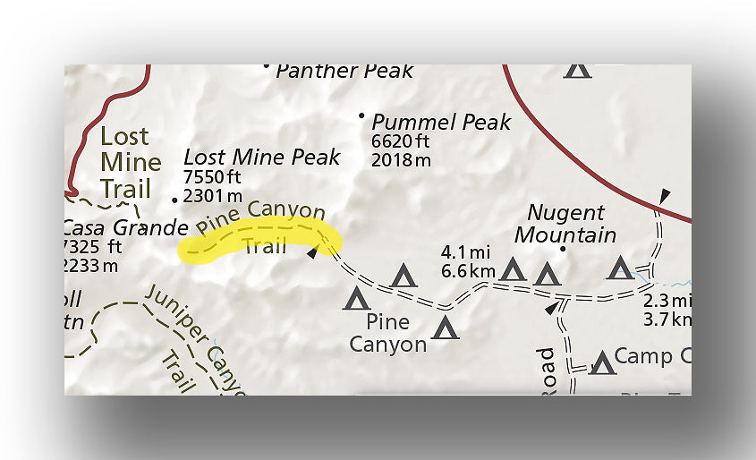
Pine Canyon Trail map, courtesy of the National Park Service
If you have a vehicle that allows you to get off the beaten path a bit (specifically, 4WD with high clearance), then you really do need to check out the Pine Canyon Trail.
This 4.3-mile trail (round-trip) climbs right around 1000 feet in total.
The hike starts off with a steady climb in the open but is not overly steep, making it qualify as a moderate trail. After about two-thirds of the way in, you’ll start to be surrounded by pine trees (along with some welcome shade). The last 0.1 mi is where it gets a bit steeper as it heads to the waterfall at the end.
Whether or not the falls are going really depends on the weather and the time of year, as sometimes it will be trickling due to dryness or frozen in the winter. There are beautiful views of the mountains the entire way up.
If you can get to this trail in your vehicle, you may find it is one of your favorites!
The trailhead for the Pine Canyon Trail is located at the end of Pine Canyon Road. It is conveniently located to several campsites, so if you are staying in the area you really must go!
ADDITIONAL TIPS FOR HIKING IN BIG BEND NATIONAL PARK
- Be advised that hiking in Big Bend National Park is typically without shade. Even hiking here in the winter can get hot, so be sure to bring plenty of water and protection from the sun.
- For water, we highly recommend having a water pack with you.
- There isn’t much in the way of great hiking maps for the Big Bend area, which is why we purchased the Big Bend hiking map from National Geographic. These maps are really durable, easy to read and very detailed.
FURTHER INFORMATION ON BIG BEND NATIONAL PARK FROM JUST GO TRAVEL STUDIOS
- Ahead of your trip, be sure to download our extensive itinerary for Big Bend National Park.
- We have several detailed blogs on Big Bend National Park, including our blog on 5 Reasons to Love Big Bend National Park. We also cover several hikes in detail, such as the Lost Mine Trail, Window Trail and the Santa Elena Canyon Trail. Also, check out our blog on the Best Airports for Big Bend National Park if you are planning on flying into the area.
- If you are planning on camping in the park, check out our blog on the Best Campgrounds in Big Bend National Park.
- We have an extensive offering of WPA style posters, including some of Big Bend National Park.

- Finally, when you return from your trip, let us turn one of your photos into a unique, vintage-style travel poster. This is a one-of-a-kind memory just for you!


