5 Best Hikes in Muir Woods National Monument: Trail Maps, Directions & More
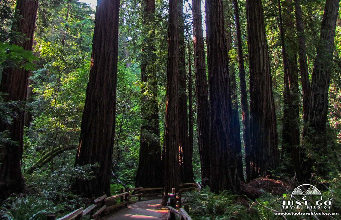
Peter BrahanOver one million people visit Muir Woods National Monument each year. Since the monument is only about 550 acres, selecting the best hike in Muir Woods commonly involves finding one that allows you to get away from the crowds. Whatever your situation, you want to plan out your time well ahead of your trip to Muir Woods, or risk not getting what you want when visiting this amazing natural land just north of San Francisco and the Golden Gate Bridge.
Most people visiting Muir Woods National Monument head out on the Redwood Creek Trail. This is for good reason, as this trail is easily accessible for all ages (even if you are in a wheelchair) and gets you quickly immersed in this amazing redwood forest. However, there are a number of trails that await those with a bit of energy and time, just waiting to be explored!
Here is our list of the best hikes in Muir Woods National Monument. Let us know if you have any favorites that we missed!
WHICH MUIR WOODS NATIONAL MONUMENT HIKE IS RIGHT FOR ME?
There really aren’t many hikes in Muir Woods, but the great thing about it is that there is something for everyone. If you are looking to get away from the crowds and spend an entire day out on the trail, there are options for you in the same way that there are options for families with small children or those in need of accessibility for wheelchairs.
This graph should help you out in identifying the best easy hikes:

If you are looking for a few moderate options, this graph should help out:

Finally, for those looking for more strenuous hikes, this chart should help guide you:

Our downloadable guide for Muir Woods National Monument will help you take the guesswork out of your planning. We let you know how to get to the park (including what reservations you have to make), information on the best hikes (included in this blog) and information on the Marin Headlands.
REDWOOD CREEK TRAIL

The Redwood Creek Trail is the most commonly taken trail in the park. This short, level hike involves a walking on a well-constructed boardwalk for the majority of the trip. Immediately after starting off, you’ll be inundated with giant redwoods. You simply won’t believe that you are less than an hour from San Francisco!
The entire hike is only about 1 mile long (round trip) and there is minimal elevation gain. The trail is accessible for wheelchairs too. In fact, pretty much anyone can head out on this trail and have a great time. The trail continues on dirt (see hike option at the end of this trail description below), but the official Redwood Creek Trail ends at Bridge #3 at the end of the boardwalk.
During the hike there are signs asking you to keep your voices to a minimum. If you are here when others are respecting those wishes, it truly is a magical place, even when there are many other people around.
We should note that this “hike” is really more of a walk through the woods. As we said earlier, it can be very crowded, which is why some of the hikes later on in this blog may be a bit more interesting to you. Still, this is an impressive walk and worth doing even if you don’t like crowds.
The trailhead for the Redwood Creek Trail starts at the main entrance to Muir Woods National Monument.
Hike option: For a slightly different experience on the way back, cross over at Bridge #3 and head back on the Bohemian Grove Trail. This trail follows the Redwood Creek, but this time from the west side. This adds on only a few extra yards to the hike.

REDWOOD CREEK TRAIL RETURNING VIA THE HILLSIDE TRAIL

Redwood Creek Trail map, including returning via the Hillside Trail, courtesy of the National Park Service
If you have a few extra minutes and a small amount of extra energy, then the starting off with the Redwood Creek Trail and returning via the Hillside Trail is a great option.
After passing by Bridge #3 (the normal turnaround point for the Redwood Creek Trail), continue to Bridge #4. At this point, you’ll crossover and start heading back on the Hillside Trail. There is a brief climb of about 100 total feet before you head along a hillside (hence the name of the trail). This is an easy trail and offers a different perspective. You get to see Redwood Creek from above but are still below the top of the canopy of trees. The Hillside Trail meets back up with the Bohemian Trail at Bridge #2, then crosses back over to the Redwood Creek Trail at bridge #1.
The total trail is about 2 miles (round-trip) and is definitely still rated as an “easy” hike.
While this hike still won’t totally get you away from the crowds, we recommend it as it is a bit less crowded and it does offer a very nice view of the Redwood forest below.
The trailhead for the Redwood Creek Trail starts at the main entrance to Muir Woods National Monument.
Hike option: Most hike this trail in the counterclockwise direction, but there is no reason why you can’t experience it in the clockwise direction. You will be against the flow of people and will then be able to descend into the forest.

REDWOOD CREEK TRAIL TO THE FERN CREEK, LOST TRAIL AND CANOPY VIEW TRAIL

Taking the Redwood Creek Trail is a nice warm up before heading into the hills on the east side of the grove on this moderate trail. This trail climbs a total of 610 feet on the 3.1-mile (round trip) hike.
After starting off on the Redwood Creek Trail for approximately 0.9 miles, the trail comes to a fork about 0.3 miles past Bridge #3. If you turn right, the trail heads along the Fern Creek Trail for about 0.3 miles before turning back to the east and heading uphill for about 500 feet on the Lost Trail. This incline is not too difficult, but it is fairly steep, as it ascends over 0.25 miles only.
After passing the crest of the trail, the Canopy View Trail then descends back to the visitor center.
The great thing about this hike is that it allows you to get away from the crowds and has a few very nice views.
The trailhead for the Redwood Creek Trail starts at the main entrance to Muir Woods National Monument, but if you are going to want to hike in reverse (see “hike option”), you’ll be picking up the Lost Trail from the visitor center.
Hike option: If you are afraid of the incline after getting on the Lost Trail, start on the Canopy View Trail from the visitor center and head counterclockwise. The climb of 600 feet is evenly spread over 1.1 miles. You can also combine it with a hike on the Hillside Trail.

DIPSEA TRAIL

Dipsea Trail map, courtesy of the National Park Service
For those wanting a much more challenging experience with a great payoff, the Dipsea Trail is definitely for you. This trail mixes hiking through the forest and hills with a visit to Stinson Beach.
This challenging trail is 9.7-miles long (round-trip) and climbs slightly over 2,500 feet total elevation gain. The climb isn’t bad, though, as it is “up and down”, with an ascent of 1,200 feet in the first 2 miles before descending the rest of the way to the beach.
The trail heads deep into the redwood forest before cresting at Cardiac Hill. The view up here is magical. It’s likely you’ll have fog, but it’s pretty nevertheless. On a clear day you can see quite a distance to the beach and beyond.
The trail continues through grasslands before descending and ending at Stinson Beach. This white sand beach is outstanding for swimming and exploring. Here you can get food as well as hit the restroom before heading back.
This is definitely one of the best Muir Woods hikes!
The trailhead for the Dipsea Trail is located at the southwest end of the lower Muir Woods National Monument parking lot.
Hike option: There are numerous other trails that can be combined with this hike, including the Bend Johnson Trail. This trail then meets up with the Hillside Trail and heads back through the Redwood Creek Trail. This will extend the hike by about 0.3-miles and has no impact to elevation gain. The split off to the Ben Johnson Trail is about 0.3 miles past Cardiac Hill (on the hike back from Stinson Beach).

Stinson Beach, courtesy of Kglavin
BOOTJACK LOOP TRAIL

Bootjack Trail map, courtesy of the National Park Service
The Bootjack Trail combines the Redwood Creek, Bootjack, TCC, Stepelveldt, Ben Johnson and Hillside Trails over a 6.3-mile loop with just over 1,150 feet in elevation gain.
After departing the Redwood Creek Trail, the trail climbs while passing through beautiful redwoods and passing several creeks along the way.
This trail is a bit challenging, as there are steep stairs and some rocks along the way. However, the hike is extremely peaceful and a great way to get away from the crowds. This trail is known for being a great experience if you are up for the climbing.
The trailhead starts at the Main Entrance to Muir Woods National Monument. Be sure to head to the left at the end of the Redwood Creek Trail, but continue west rather than turning all the way onto the Hillside Trail on the way out.
ADDITIONAL MUIR WOODS HIKING TIPS (AND INFORMATION ON THE SURROUNDING AREA)
- Ahead of your trip to Muir Woods, we recommend grabbing a download of the map for Muir Woods hiking trails. This will save you a bit of time when you first get to the monument. Another great option is to get the Muir Woods National Monument Trail map from National Geographic. This is tear-resistant and waterproof, and best of all it’s extremely detailed. It also includes information on nearby Point Reyes and Mount Tamalpais.
- Nearby Mount Tamalpais State Park has breathtaking views, mountain biking and even more hiking trails to go on. For information, check out the Mount Tamalpais State Park guide from the California Parks Service.

Mount Tamalpais State Park, courtesy of the State of California
FURTHER INFORMATION ON MUIR WOODS NATIONAL MONUMENT AND THE SURROUNDING AREA
- Be sure to download your copy of the Muir Woods National Monument Itinerary. We cover what you need to know ahead of your visit and you’ll appreciate having the help as you work on planning your trip to this amazing location!
- If you are looking for a good overview, check out our blog on what to see and do in Muir Woods National Monument. We include information about how to get to the park as well-you’ll want to read this, since reservations are required and it can also get very crowded. We’ll give you some tips on how to plan out your trip and get to the park.
- Just south of Muir Woods is the Marin Headlands. One of the best hikes there to see amazing an amazing view is covered in our blog on Hiking to the Point Bonita Lighthouse. Of course, we highly recommend it! It is only open during certain times of the week, so check out our blog for the latest information!
- If you love Muir Woods National Monument and want to remember your trip forever, check out our WPA poster on Muir Woods National Monument. It is part of our WPA poster collection-we have many to choose from to add to your collection!

- In addition to our standard posters, we can also make a custom, vintage-style poster for you from one of your photos. This unique product is a great way to remember your trips forever!


