Best Easy Hikes in Zion National Park: Trail Maps, Directions & More
Peter BrahanZion National Park is a fantastic destination for hikes of all kinds. From the famous Angels Landing and Observation Point to hiking down the Virgin River through the Narrows, there are a ton of day hikes in Zion that are out of this world.
In addition to these more well-known hikes, it’s also full of a variety of easy hikes that are great for young families, those short on time, have a fear of heights or perhaps are just not able to climb hundreds of feet in elevation over a short distance.
That’s exactly why we wanted to put together this list of some of the best easy hikes in Zion National Park!
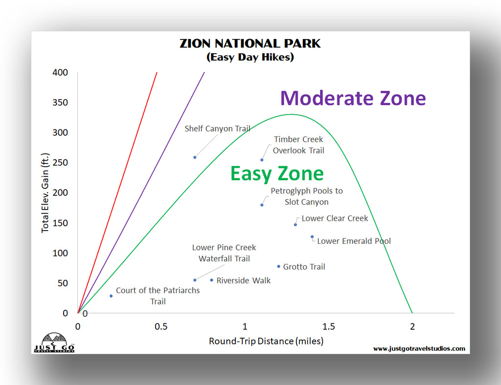
To start off, we put together the Best Easy Hikes in Zion National Park into an easy-to-read chart. This should help you identify what hike is right for you, in addition to our commentary below!

Our Zion National Park Itinerary covers what you need to know to help you get started on your trip planning. We cover the best hiking trails (in ranked order), what to pack, Zion National Park maps, where to stay near Zion and what else to do while you are in the area. We even cover the lesser known Kolob Canyon!
RIVERSIDE WALK
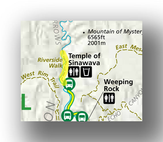
Riverside Walk map, courtesy of the National Park Service
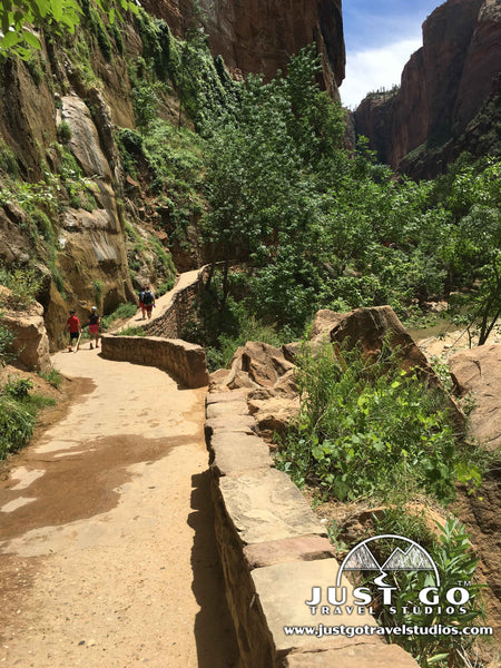
The Riverside Walk is a very popular trail, particularly if you want to get out of the sun and have access to water. Starting at the Temple of Sinawava (which is shuttle stop #9, all the way at the end of the shuttle route), the trail only gains a few feet in elevation over the 2-mile, out and back route.
The trail travels along the Virgin River and leads up to the beginning of the Narrows, which is an amazing (but more challenging) “hike” inside the Virgin River. While the Narrows was one of our favorite hikes of all time, it is definitely not easy and you should be prepared with proper gear prior to starting out on this journey.
Along most of the Riverside Walk there are places where you can get off the trail and take a dip in the water to cool off. In fact, it’s easy to spend hours just relaxing in this area, enjoying the cool water (or downright cold water, depending on the time of year) from the Virgin River.
The trailhead starts at the Temple of Sinawava (shuttle stop #9). This hike is particularly popular during the heat of the day due to the large amount of shade on the trail.
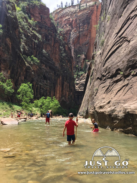
Hike Option: The Narrows (which adds up to 9.4 miles roundtrip) is one of the most popular hikes in the park. Take it, even for a mile or two if you are prepared!
LOWER EMERALD POOL TRAIL
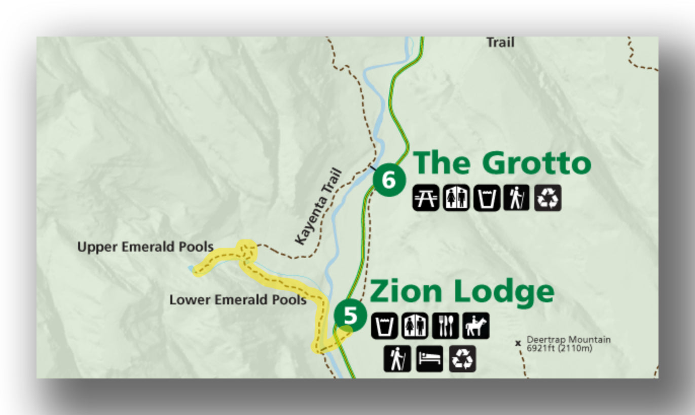
Emerald Pool Trail map, courtesy of the National Park Service
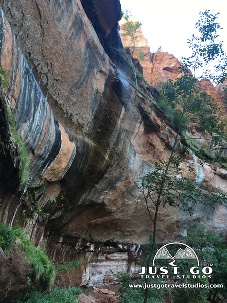
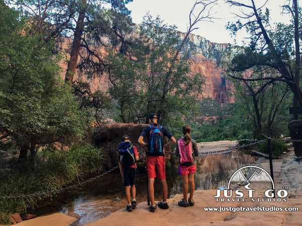
The Lower Emerald Pool Trail is a paved, 1.3-mile round trip hike with 154 feet in elevation gain. Starting from shuttle stop #5 (which is directly across from the Zion Lodge), this easy hike leads to the picturesque lower Emerald Pool along with a small waterfall. The trail is in the shade for much of the hike (keep your eye out for deer!), making it a great place to go to escape the heat (with the exception of the first part of the hike, which passes over the Virgin River in the open).
While this is a terrific hike for families, deaths at the Emerald Pools are actually more common than even Angels Landing. This is purely due to people going to out-of-the-way places to get great photos. Please resist the urge to do so and make sure your kids do the same!
To access the Lower Emerald Pool Trail, take the Zion shuttle to stop #5.
Hike Option: Continue on past the Lower Emerald Pool to the Upper Emerald Pool Trail (a moderate hike, which adds on about 1-mile round trip and climbs and additional 200 feet in elevation). Another option is to take the Kayenta Trail, which ends at shuttle stop #6 and is 2.5-miles total.
WEEPING ROCK TRAIL
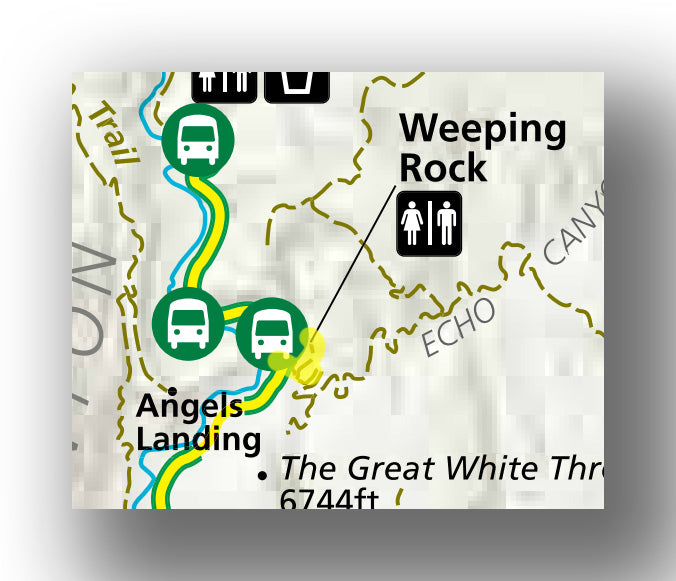
Weeping Rock Trail map, courtesy of the National Park Service
The Weeping Rock Trail is only 0.4-miles long. While short, it does gain 173 feet in elevation which makes it quite steep. Still, this short trail is worth it. Along the way you’ll have views down into Zion Canyon, which are breathtaking. This is a great way to see the canyon if you aren’t doing any other, more challenging hikes in the park.
Much of the trail is in the shade of trees as you hike back and forth, gaining in elevation.
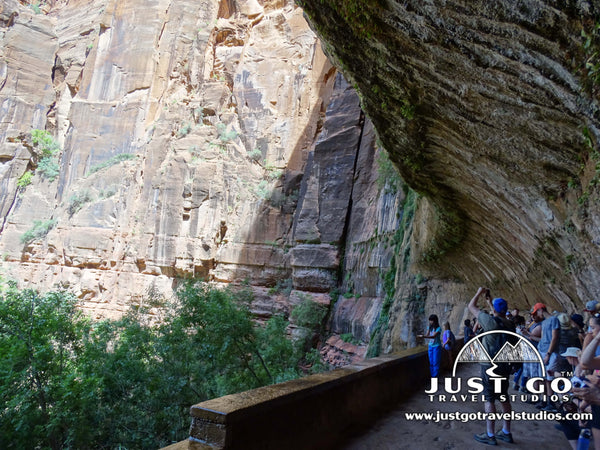
At the end of the trail you’ll reach Weeping Rock, which is famous for the water that comes out of the rockface where two different types of standstone meet. This area also has a concentration of lush vegetation, including moss and ferns.
To access the Weeping Rock Trail, take the Zion shuttle to shuttle stop #7.
PA'RUS TRAIL
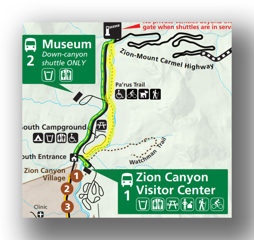
Pa’rus Trail map, courtesy of the National Park Service
The Pa’rus Trail is nice due to its proximity to the main entrance of the park. Starting at the Zion Canyon Visitor Center, the trail climbs just 223 feet over its 3.3-mile round trip distance. The trail is well traveled and can get busy, but it is a great “last hike” in the late afternoon / early evening if you are looking to avoid crowds. Another tip is to hike this trail one-way from shuttle stop #2.
Along the trail there are footbridges and meadows along with several spots to stop and take a dip in the Virgin River.
To access the Pa’rus Trail, start at the Zion Canyon Visitor Center (shuttle stop #1) or start just to the north at the Human History Museum at shuttle stop #2.
TIMBER CREEK OVERLOOK TRAIL
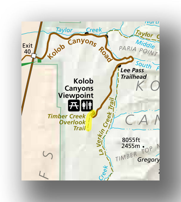
Timber Creek Overlook Trail map, courtesy of the National Park Service
In the secluded and less-popular Kolob Canyon area of Zion National Park, the Timber Creek Overlook Trail is a perfect way to see the area without having to expend too much energy. The round-trip trail is only 1.2 miles and only climbs 120 feet in elevation. After traveling along a ridge, it ends with great views of the Kolob Canyons.
While you are in the Kolob Canyon area, make sure you also check out the Kolob Canyons Visitor Center.
To access the Timber Creek Overlook Trail, head to Kolob Canyon, which is a 45-minute drive from Springdale, Utah (the main entrance at Zion National Park). Check out these directions from Springdale to Kolob Canyon. The trail is at the end of the Kolob Canyons road, where there is also a picnic area and restrooms.
Hike Option: The Taylor Creek Trail is 5.0 miles long and will take about 3.5 hours. On this quiet trail there are about 20 creek crossings, making it really fun for kids to visit. There is also a double arch at the end of the trail. We highly recommend taking this hike if you have the time and energy!
OTHER GREAT DAY HIKES IN ZION NATIONAL PARK
There are many hikes in Zion National Park, but these are a couple that are just barely into the "moderate" range of difficulty that you may want to also consider during your visit.
- The Watchman Trail: If you are looking for a moderately challenging hike in Zion National Park but without the danger of Angels Landing, a great one to check out is the Watchman Trail. We cover what you can expect while hiking this great trail in our blog. While not difficult, this trail does gain over 600 feet over its 3.2-mile round-trip distance, making it not an entry level hike but still doable for many families.

- The Canyon Overlook Trail: Near to the eastern entrance of the park, the Canyon Overlook Trail is short (1.0 miles) with not much elevation gain, but it does move along a bare slickrock making it a bit more challenging for people who may not be great on their feet. Oliver (from “Hiking the World”) has some great information on this hike in his blog on Hiking the Canyon Overlook Trail.
FURTHER INFORMATION ON ZION NATIONAL PARK FROM JUST GO TRAVEL STUDIOS
- We cover information on all these easy trails in Zion National Park and much more in our downloadable itinerary for Zion National Park.
- We loved our experience in Zion National Park and think you will too. Check out what we thought were the best parts in the park in our blog, 7 Reasons to Love Zion National Park.
- If you want to go hiking in a less-populated part of the park, be sure to check out our blog on Kolob Canyon Hikes. Also check out our blogs on the Watchman Trail, Angels Landing and the Emerald Pools Trail. Finally, if you are flying into the area, you’ll want to check out our blog on the Best Airports for Zion National Park.
- For those that love to camp, check out our blog on Camping in Zion National Park.
- After your trip, send us a photo so we can create custom, vintage-style posters, postcards and note cards that are personalized and made just for you!

OTHER USEFUL LINKS ON ZION NATIONAL PARK
- Of course, the National Park Service has a large amount of information on their website for Zion National Park. We highly recommend checking their site out for up-to-date information on shuttle bus schedules in particular.