8 Best Hikes in Saguaro National Park: Trail Maps, Directions & More
Peter BrahanIf you are traveling in the southwest and visiting Saguaro National Park, you can see plenty of great views without ever having to leave the car. But to really see the park, you have to get out and hike. To assist with your planning, we put together this list of what we consider to be the Best Hikes in Saguaro National Park.
While there are a ton of great hikes in the park, we did our best to narrow them down to a reasonable list to help you get started. We also tried to pick a few that are suitable for all skill levels, whether you just want a short walk without too much elevation gain or are looking for an all-day adventure.
Just be advised, that no matter what hike you do, the sun is hot in this part of the country-be sure to bring plenty of water with you, as well as protection from the sun!
WHAT SAGUARO NATIONAL PARK DAY HIKE IS RIGHT FOR ME?
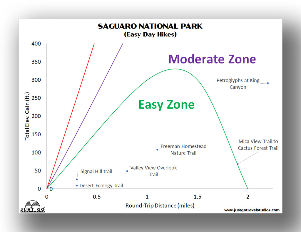
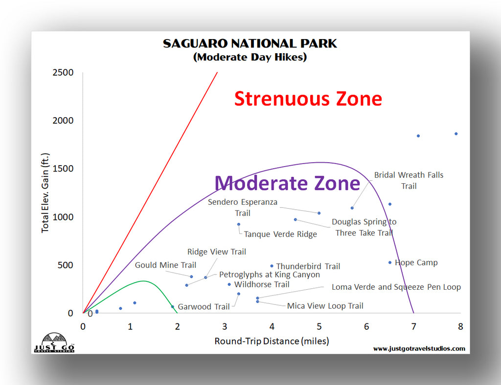
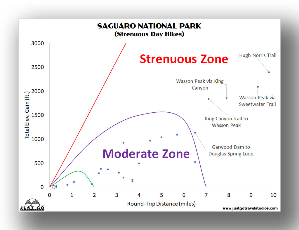
What hike is right for you really depends heavily on a variety of things, including your skill level, energy level for the day and how much time you have. To help out, we put together an overview of the major hikes in Saguaro National Park, the length and difficulty of each. The charts below will give you a start.
If you want to see as much as possible or don’t have much time, we suggest the easy hikes in the chart below.
For those that have a bit more time on their hands, this chart of moderate day hikes will give you a few ideas.
Finally, if you have the better part of a day or several days, the strenuous hikes in the chart below are great to choose from.
Our Saguaro National Park Itinerary is a downloadable guide that will help you plan out your trip to this amazing park. We include information on the best hikes, what to pack, useful maps and 1, 2 and 3 day itineraries based on your travel style.
TUCSON MOUNTAIN DISTRICT HIKES
HUGH NORRIS TRAIL TO WASSON PEAK
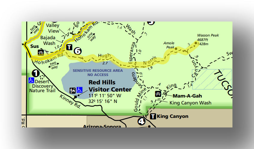
Hugh Norris Trail map, courtesy of the National Park Service
One of the harder hikes in Saguaro National Park is the Hugh Norris Trail. This incredible hike will take the better part of a day, but climbs up to one of the best views in the park, Wasson Peak.
After heading out from the trailhead, the Hugh Norris Trail travels nearly due west. At the 0.2 mark, the trail starts to head uphill a bit more steeply, aided by a couple sets of switchbacks. The incline then gets a bit shallower as it continues to Amole Peak. About 0.6 miles later, the trail ends at Wasson Peak, which is an elevation of over 4,600 feet.
The views from the top of the peak are impressive-a 360-degree view of the surrounding area.
The round-trip distance is about 10 miles, and the total elevation gain is nearly 2,400 feet. While not overly challenging, you do need to be prepared for being exposed and you should plant to be out on the trail for 5 hours or more.
The trailhead is located in the Tucson Mountain District, about 1 mile east of the junction of Kinney Road and the Bajada Loop Drive on Hohokam Road.

Hugh Norris Trail in Saguaro National Park , courtesy of Brewbooks
GOULD MINE TRAIL
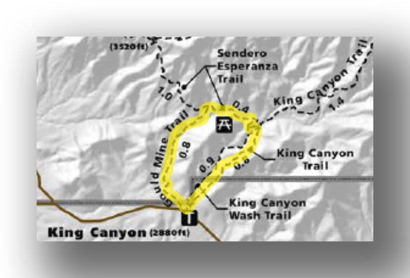
Gould Mine Trail map, courtesy of the National Park Service
If you are looking for a moderately challenging trail with great scenery, the Gould Mine Trail is a great choice. It isn’t a short trail and may not be for everyone, as it is exposed and has a bit of elevation gain. However, it’s a fantastic option if you only have a few hours.
After departing the King Canyon parking area, the trail heads to the northeast along the King Canyon trail. The flat entry to the trail ends up climbing slowly for the next 0.8 miles. To get to the mine, take a left and head by the Mam-A-Gah picnic area as you head to the Gould Mine.
There isn’t much in the way of mine ruins at the site of the mine, but there are tailings and the foundations of the blacksmith shop and the mess hall.
The great part of the trail (in our opinion) is as you head back to the parking area. The views are amazing, particularly in the early morning or the evening as dusk approaches.
The hike is a total of 2.3 miles (round-trip), with a total elevation gain of just shy of 400 feet. Most can complete the trail in 90 minutes or so.
The trailhead is located in the Tucson Mountain District of Saguaro National Park just off North Kinney Road.
Hike option: For a longer hike, there are also connections with the King Canyon Trail and the Sendero Esperanza Trail. These hikes are also covered in this article.

KING CANYON TRAIL TO WASSON PEAK
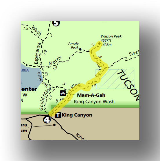
King Canyon Trail map, courtesy of the National Park Service
There are several ways to get to Wasson Peak, and this route is likely the easiest way. Don’t be fooled, though as it is a challenging hike and you need to be prepared!
The trail starts from the King Canyon trailhead and shares the same trail (for the first 0.9 mi) as the hike to the Gould Mine. After passing the Mam-A-Gay picnic area on the left, the trail heads straight and continues as the King Canyon Trail. The trail continues for another 1.2 miles as you head up at a slightly steeper pace.
At the 2.2-mile point, the trail cuts off to the northwest (don’t continue straight) and heads up the mountain further, aided by switchbacks. While it’s not easy, the views are amazing and will help you keep the pace!
At the 3.1-mile mark, the trail heads back to the northeast for the final push to Wasson Peak. The total distance is about 6.7 miles with an elevation gain of just over 1800 feet.
The trailhead is located in the Tucson Mountain District of Saguaro National Park just off North Kinney Road.
Hike option: If you are in for a longer hike, you can then head of the peak to the west on the Hugh Norris Trail, then pickup the Sendero Esperanza Trail, which heads back and makes a loop back to the Gould Mine Area. This would make the trail about 8 miles total.

King Canyon Trail in Saguaro National Park, courtesy of Daveynin
SENDERO ESPERANZA TRAIL TO WASSON PEAK
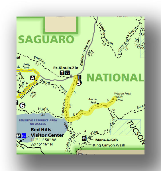
Sendero Esperanza Trail to Wasson Peak Trail map, courtesy of the National Park Service
As you have figured out by now, there are a few ways to get up Wasson Peak to see the amazing view! The Sendero Esperanza Trail is a bit longer than the King Canyon Trail route. The elevation gain is similar, but it happens over a shorter distance and it can be a bit more sandy. Still, many think this is an easier way up to Wasson Peak as compared to the longer Hugh Norris Trail.
Starting from the Golden Gate Road (an off-road vehicle is recommended to get to the parking area), the trail heads south through a sandy and tree-lined area. The change of scenery is quite a change from the rest of the park. The trail meets up with the Hugh Norris Trail at the 1.7-mile point, when it heads east up the rest of the way to Wasson Peak. The trail is steepest at the 1.4-mile mark as it gains in elevation up the ridge before turning east.
As stated earlier, the views from Wasson Peak are worth the effort! In total, this route is 7.9 miles and gains about 2600 feet in elevation.
The trailhead is in the Tucson Mountain District on the Golden Gate Rd, about 1 mile east of the intersection with the Bajada Loop Drive.
Hike option: Just hiking the 1.7 miles out to the ridge (when you meet up with the High Norris Trail) is a great option and has a great view without heading all the way up to Wasson Peak.
SWEETWATER TRAIL
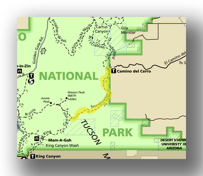
Sweetwater Trail map, courtesy of the National Park Service
If you want a great view in an area of the park that is less crowded, head to the east side of the Tucson Mountain District. From the Camina del Cerro Road, you can get to the Sweetwater Trail.
After leaving the parking area, the trail heads south and is relatively flat for the first 1.8 miles. Once it starts to climb, it does so gradually and ends with a great view from the Sweetwater Saddle.
The entire hike is about 7 miles round-trip, with a total elevation gain of just over 1000 feet.
The trailhead for the Sweetwater Trail is in the Tucson Mountain District at the end of El Camino del Cerro Road. You cannot get to the trailhead from inside the park, so it does take a bit of planning!
Hike option: Continue 0.9 miles to Wasson Peak, which adds another 1000 feet in elevation gain.
VALLEY VIEW OVERLOOK TRAIL
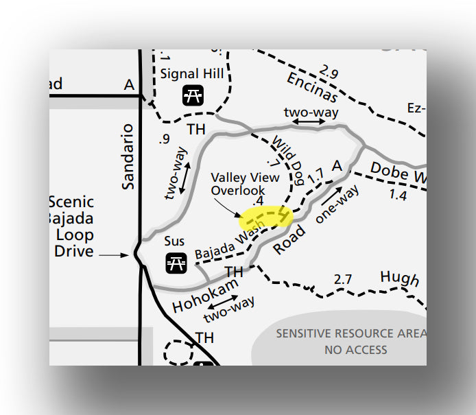
Valley View Overlook Trail map, courtesy of the National Park Service
An easy, yet rewarding hike in Saguaro that is good for all skill levels is the Valley View Overlook Trail. This short hike is a great way to split up the drive on the Bajada Loop and has amazing views!
After leaving the parking area, the trail heads through a wash after descending briefly. The trail continues straight before heading left to get to the Valley View Overlook. While mostly flat, the trail takes hikers through the breathtaking saguaros and winds through foliage before climbing the last 40 feet in elevation.
The overlook has amazing views of the Avra Valley and Picacho Peak, which rises to the north of the overlook.
The entire trail is short. At only 0.8 miles (round-trip) and only 50 feet in elevation gain, it’s ideal for anyone that is up for a short walk!
The trailhead for the Valley View Overlook Trail is in the Tucson Mountain District on Bajada Loop Drive, about 1.4 miles east of the start of the road.

RINCON MOUNTAIN DISTRICT HIKES
DOUGLAS SPRING TRAIL TO BRIDAL FALLS
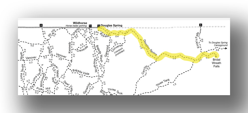
Douglas Spring Trail to Bridal Falls Trail map, courtesy of the National Park Service
Finding water in the desert is a bit of a challenge, but this hike helps you out! The Douglas Spring Trail is a moderately challenging hike with a modest climb that leads to a slow flowing waterfall. If you head out on this hike after a recent rain, the waterfall will be a bit more impressive!
After leaving the trailhead, the Douglas Spring Trail heads east. After about 0.7 miles, the trail turns to the southeast as it begins a slow increase in elevation. The steepest part of the trail is between the 1- and 2-mile point, but don’t worry, it’s gradual and fairly easy.
Once hikers see the sign to Bridal Falls, it’s only about 0.3 miles more before the trail reaches the falls. Don’t expect a ton of water here, but there are great views on this hike and the endpoint has some pretty cool geologic features to check out!
In total, this is about 6 miles round-trip, with a total elevation gain of nearly 1150 feet.
The trailhead for the Douglas Spring Trail is in the Rincon Mountain District at the end of Speedway Blvd, which is the northern border of the park.
Hike option: Head back to the parking area via the Three Tank Trail and Wildhorse Trail to make a loop.
MICA VIEW LOOP TRAIL
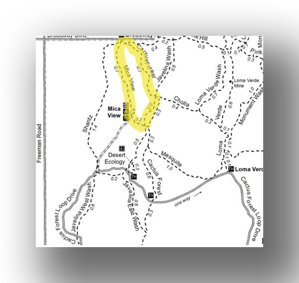
Mica View Loop Trail map, courtesy of the National Park Service
For an easy walk, this is a great trail that will also help break up the Cactus Forest Drive. After leaving the parking area, head north on the Mica View Trail.
At the 0.7-mile point, you’ll have a few options, but taking the Cactus Forest Trail to the right will head back to the parking area. You can also head to the east on the Pink Hill Trail and then make a longer loop via the Javelina Wash Trail or Loma Verde Wash Trail.
Th is trail is great for families. The total elevation gain is about 130 feet over a total distance of 2 to 3.8-miles (depending on the route you take).
The trailhead for the Mica View Loop Trail is in the Rincon Mountain District, about 2 miles north of the Visitor Center off Cactus Forest Drive.
SAGUARO NATIONAL PARK HIKING PERMITS
If you are looking to stay overnight in the backcountry, then you’ll need to get a permit. Don’t worry, they are easy to get, and can be obtained at www.recreation.gov or by calling 1-877-444-6777.
FURTHER INFORMATION ON SAGUARO NATIONAL PARK FROM JUST GO TRAVEL STUDIOS
- Ahead of your trip, be sure to download a copy of our Saguaro National Park Itinerary. We include everything you need to know about the park, including what to pack and what to see in the area.
- Check out our other blogs on Saguaro National Park, including What to See and Do in Saguaro National Park, hiking the Valley View Trail and hiking the Gould Mine Trail.
- We have an extensive selection of WPA style National Park posters, including our Saguaro National Park Poster.
- Be sure to check out nearby Catalina State Park!
- We can create some pretty cool vintage posters from a photo that you send us! See the product information in our product listing for custom, vintage-style posters, postcards and note cards.