Pictured Rocks National Lakeshore: Things to Do, Maps, Tours, Weather & More
Peter BrahanLocated on the north shore of Michigan’s Upper Peninsula, Pictured Rocks National Lakeshore is best known for its colorful sandstone cliffs towering over Lake Superior. In 1966, Pictured Rocks was established as America’s first national lakeshore to protect over 42 miles of shoreline along Lake Superior’s south shore.
No matter how you decide to explore the dramatic lakeshore landscape, Pictured Rocks and the surrounding area will keep visitors busy for days! We hope this guide will help you narrow down your options and plan an amazing trip to Pictured Rocks National Lakeshore!
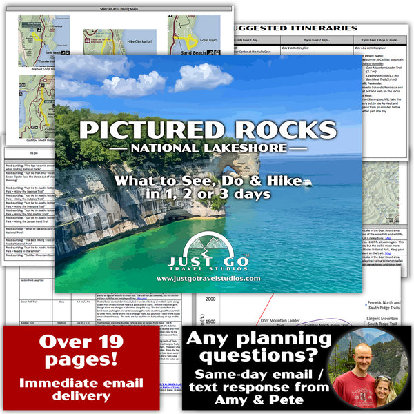
Before you head to Pictured Rocks National Lakeshore, make sure you pick up a copy of our downloadable Pictured Rocks Itinerary. Not only do we cover the best things to do at Pictured Rocks, we also include details on hiking trails, where to stay, what to pack and other places to visit while you are in the Pictured Rocks area.
PICTURED ROCKS NATIONAL LAKESHORE HISTORY AND BACKGROUND
Prior to earning its designation as a national lakeshore, this once remote area of Michigan’s Upper Peninsula was valued for its natural resources. For hundreds of years, the area was utilized by Native American tribes for hunting and fishing and later by European explorers searching for furs and minerals.
With increased demand for lumber in the 1800s, European and American settlers arrived in the Upper Peninsula and began purchasing vast forests to harvest one of the lakeshore’s most plentiful resources. Boomtowns sprung up along the Lake Superior’s southern shore to support logging operations and the iron industry (blast furnaces in the area produced pig iron for railroad expansion). However, the ironworking industry was short lived; and, although the logging industry flourished in the Pictured Rocks area for decades, the depletion of white pine led to the closure of most logging operations by the early 1900s.
Over the period of the next century, this section of the Upper Peninsula transitioned from an area supported by a forest product economy to a tourist destination. It was the hope that the void of the logging industry would be filled by tourism. However, prior to its establishment as a national lakeshore, access to the famed “pictured rocks” and scenic shoreline was limited. On October 15, 1966, Lyndon B. Johnson signed several wilderness bills into action, one of which established Pictured Rocks as the country’s first national lakeshore. This designation resulted in the development of park roads and trails which granted easier access to the park’s scenic landscape and, in turn, increased tourism.
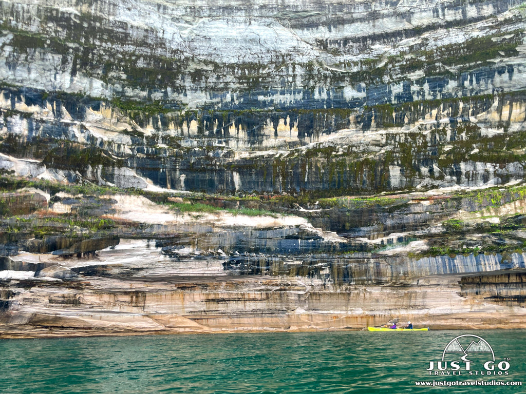
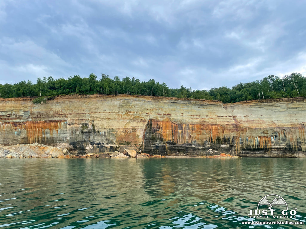
Now over a million visitors come to Pictured Rocks National Lakeshore every year to enjoy the spectacular scenery and take part in a variety of recreational activities. Of course, viewing the “pictured rocks” for which the park is named is a MUST! The colorful streaks occur when groundwater drips from cracks in the mineral rich rock and runs down the rock face--leaving bands of green and blue (copper), red and orange (iron), black (manganese) and white (limonite). Since the best way to view the mineral streaked cliff faces is from the water, boat tours and guided kayak trips are a popular tourist activity.

Pictured Rocks National Lakeshore map, courtesy of the National Park Service
WESTERN AREA OF PICTURED ROCKS NATIONAL LAKESHORE

Pictured Rocks National Lakeshore western area map, courtesy of the National Park Service
The western area of Pictured Rocks National Lakeshore, northeast of Munising and off H58, is home to one of the park’s visitor centers and several popular attractions. There is plenty to see and do in this area of the park—including miles of hiking trails, waterfalls, and pristine beaches. Regardless of how much time you have at Pictured Rocks, be sure to allow for at least a day to explore the western end of the park.
When visiting the western area of Pictured Rocks, our recommendations include:
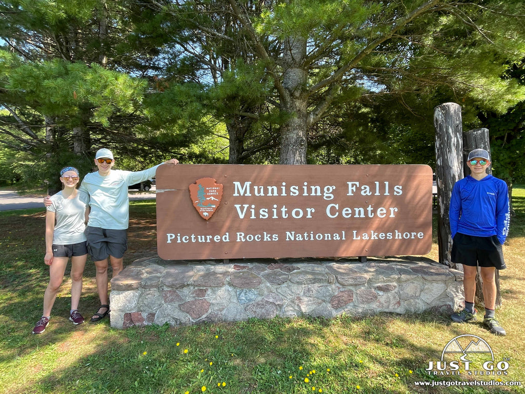
Munising Falls Visitor Center/Contact Station
The Munising Falls Visitor Center is currently closed due to structural maintenance work; however, information about the park is available on outside bulletin boards. During summer months, park passes can be purchased at a temporary visitor contact station from 9-5. Park rangers can also help you make the most of your time in the park. Restrooms are available near the trailhead to Munising Falls. Hikers can also access the western park segment of the North Country National Scenic Trail. During the off-season, visitors can stop by the Interagency Visitor Center in the town of Munising for maps, information, and exhibits. This center serves both Pictured Rocks National Lakeshore and nearby Hiawatha National Forest.
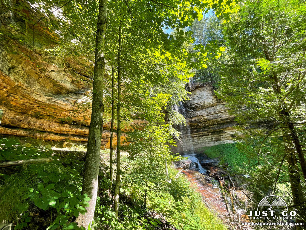
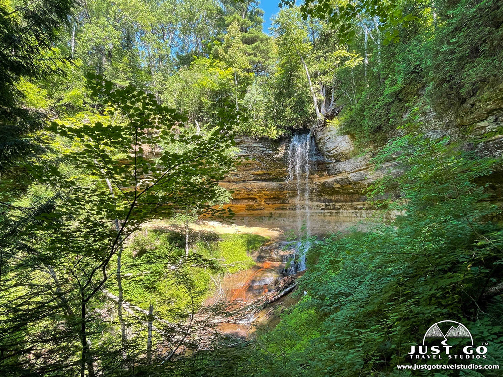
Munising Falls
Walk a short, paved trail (800 feet one-way) through a shaded sandstone canyon to the base of Munising Falls. Two sets of stairs lead to additional platforms for viewing the 50-foot waterfall as it drops over the sandstone cliff. Walking off-trail, into or behind the falls, is prohibited. Leashed pets are allowed on this trail. The main trail to the base of the falls is wheel-chair accessible.
Sand Point
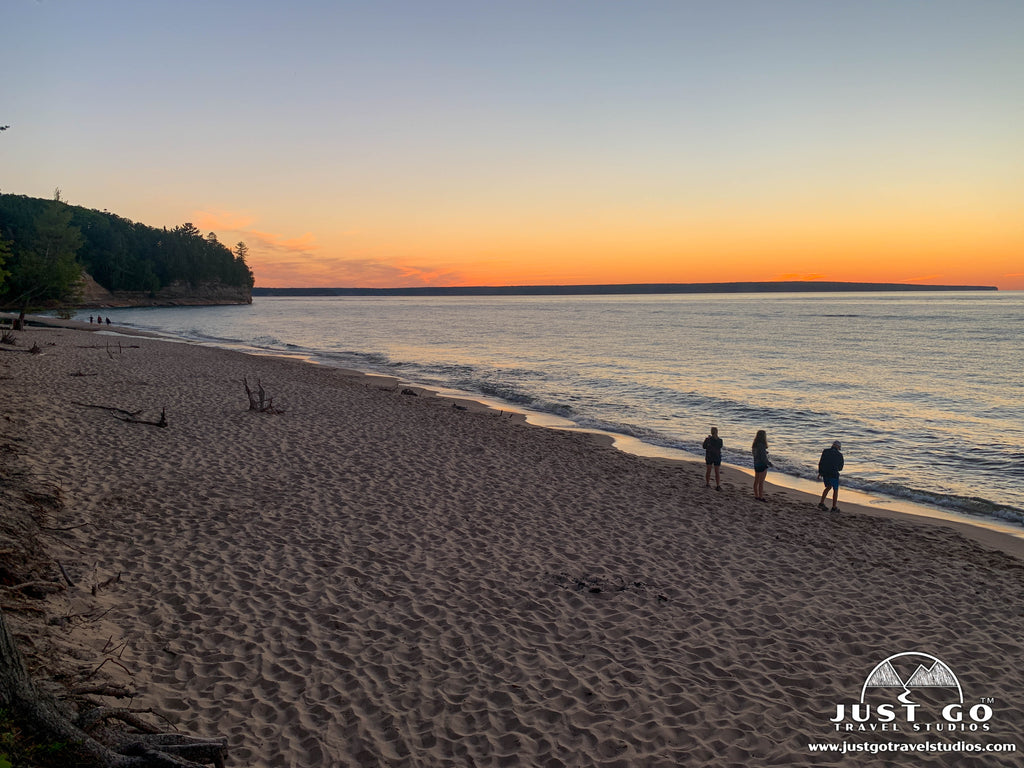
Located just outside of the town of Munising, Sand Point Beach is the most family-friendly, sandy beach at Pictured Rocks. The shallow bay water off Sand Point is generally calmer and slightly warmer than the other park beaches. Since it faces west, it is also a great spot to enjoy a sunset over Munising Bay. In the summertime, artifacts from the Coast Guard era are on display at the historic boathouse, located near the park headquarters at Sand Point. Across from Sand Point Beach, you can also stroll the boardwalk of the 0.5-mile Sand Point Marsh Trail. This beautiful wetland area is a great place for birding. Leashed pets are allowed on the beach and in the water, but no pets are allowed on the Sand Point Marsh Trail. Both the beach and the boardwalk trail are wheel-chair accessible. Sand Point Beach is the only beach with a wheel-chair accessible mat that extends from the parking lot, across the beach, and out to the water’s edge.
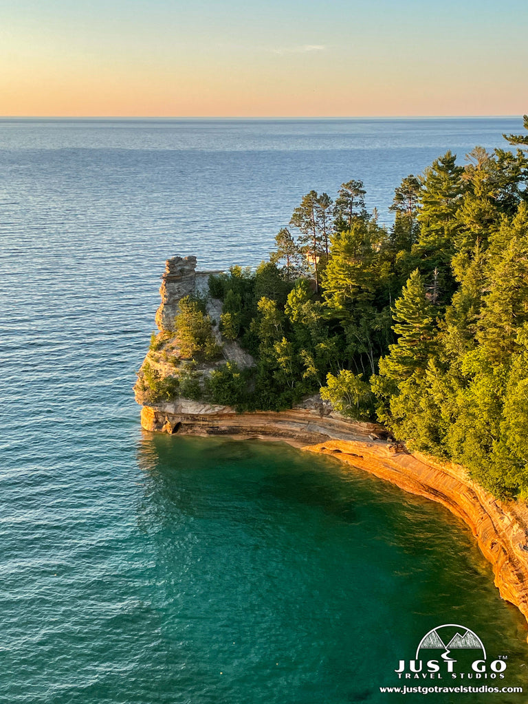
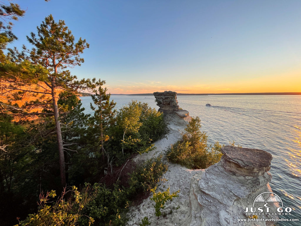
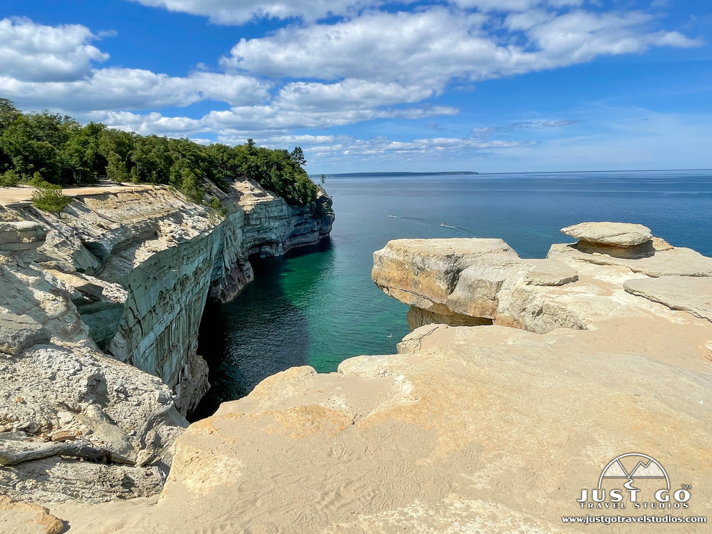
Miners Castle
Since it is the only place in the park where cliff views are accessible by vehicle, Miners Castle is one of the most popular areas at Pictured Rocks. Walk a short, paved trail from the parking lot to the upper overlook—a large wooden platform which provides spectacular views of the cliffs and one of the most famous landmarks along the Pictured Rocks shoreline. Wooden stairs and a steeper trail lead visitors down to a lower overlook for a closer view of Miners Castle. Erosion created the interesting castle-shaped rock formation which juts out into Lake Superior. In April 2006, one of the turrets collapsed and fell into Lake Superior. Despite the partial collapse, it is still a MUST SEE and especially stunning at sunset! Leashed pets are allowed on the paved trail to the overlooks. Only the main trail to the upper overlooks is wheel-chair accessible.
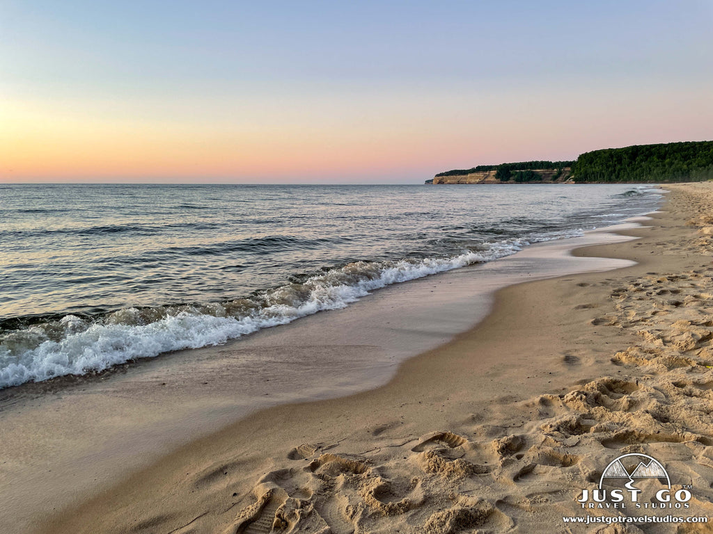
Miners Beach
Pair a visit to Miners Castle with a quick drive down the road to Miners Beach. Follow a short, boardwalk trail through a forested area to a small wooden platform overlooking the beach. The stairs adjacent to the platform lead down to the sand. This beautiful, sandy beach stretches for nearly a mile along Lake Superior with cliffs rising from both ends. Miners Beach is a great place to take a walk along the beach or enjoy sunset. Since many kayak tours leave from this beach, it may be crowded on summer days. However, we found it almost deserted at sunset on a summer evening! Leashed pets are allowed. Only the platform overlooking the beach is wheel-chair accessible.
Hiking
There are miles of trails to explore in western region of Pictured Rocks National Lakeshore—ranging in distance and difficulty. We cover all you need to know about hiking in our blog on the Best Hikes in Pictured Rocks National Lakeshore. In addition to the short trails already mentioned, we recommend the following hikes:
- Chapel Mosquito Loop Trail (moderate, 10.2-miles (round-trip), 752 ft. elevation gain)). This is the hike you want to do if you only can do one (and you have the time!).
- Miners Falls Trail (easy, 1.2-miles (round-trip), 155 ft. elevation gain)). This is rolling through the forest to Miners River with a waterfall!
- Miners Castle to Miners Beach Trail (moderate, 2.0-miles (round-trip), 258 ft. elevation gain)). This trail heads on the North Country Scenic Trail to a beautiful beach!
EASTERN AREA OF PICTURED ROCKS NATIONAL LAKESHORE

Pictured Rocks National Lakeshore eastern area map, courtesy of the National Park Service
Just a couple miles west of Grand Marais, the eastern area of Pictured Rocks National Lakeshore is home to a seasonal visitor center, enormous sand dunes, a stunning waterfall, and a light station. It takes about an hour from Munising to drive to this part of the park (unless you are staying in Grand Marais), so be sure to allow plenty of time for driving and exploring the eastern end of the park.
When visiting the eastern area of Pictured Rocks, our recommendations include:
Grand Sable Visitor Center
The Grand Sable Visitor Center is located at the eastern gateway to the park and just a couple miles from Grand Marais. It is only open during the summer, Wednesday through Saturday (9am to 5pm). This summer-season center has maps, exhibits, a small park store and restrooms (when the center is open). It is closed between October and May.
Grand Sable Dunes
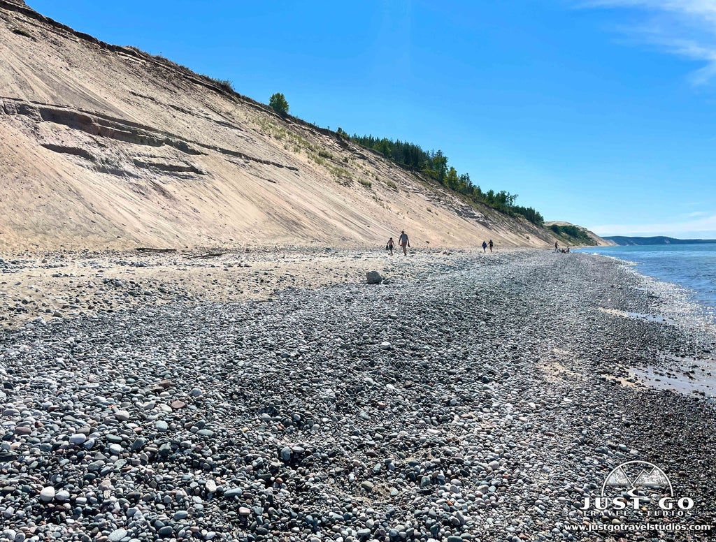
The eastern end of the park is also home to the impressive Grand Sable Dunes perched atop the 300-foot high Grand Sable Banks. Left by glacial action, they are among the best examples of perched dunes in the world; and a large portion of the dunes is set aside as Research Natural Area. The best place to view the dunes is from the 0.6-mile (roundtrip) Grand Sable Dunes Trail which begins at the Sable Falls parking area.
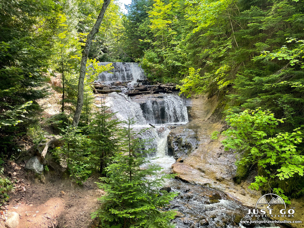
Sable Falls
Visitors to the eastern end of the national lakeshore won’t want to miss seeing the 75-foot Sable Falls as it tumbles over a slope of sandstone. From the Sable Falls parking area, the Sable Falls Trail leads to a staircase of 168 steps down to the base of the falls.
Log Slide Overlook
The Log Slide Overlook Trail leads to the site of a former log slide, where logs were sent down to the lake’s edge via a wooden chute. The chute no longer exists, but a short out-and-back trail (0.25-miles roundtrip) leads to the Log Slide scenic overlook on the western edge of the Grand Sable Dunes.
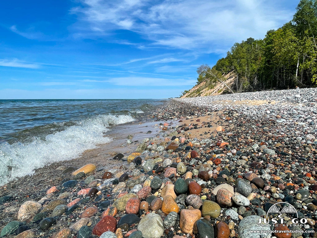
Hurricane River Beach
Located at the mouth of the Hurricane River, this beach is a mix of sand and colorful rocks. A short path and flight of stairs leads down to Hurricane River Beach. To reach Hurricane River Beach, park at the day-use area of the Lower Hurricane River Campground. Remember that rock collecting is prohibited throughout the national lakeshore. Leashed pets are allowed.
Lake Superior Overlook and Beach Access
The Lake Superior Overlook is a wooden, wheel-chair accessible platform with a view of Lake Superior. There is also stairway access down to the beach, which is a portion of Twelvemile Beach. The overlook is located just off H-58 between the turnoffs for Twelvemile Beach and Hurricane River. Leashed pets are allowed.
Twelvemile Beach
Twelvemile Beach is the perfect spot for a long walk along the Lake Superior shoreline! Extending east of the Pictured Rocks cliffs, this 12-mile-long white sand beach is also a great place to escape the crowds typical at beaches closer to town. Aside from the access point at the Lake Superior Overlook, visitors can reach the beach via the day-use area at the east end of the Twelvemile Beach Campground. A long flight of stairs leads from the bluff down to the beach. The day-use area at the Twelvemile Beach Campground is located about 16 miles west of Grand Marais on H-58. Leashed pets are allowed.
Hiking
Most of the trails in the eastern area of Pictured Rocks are less than a mile long (see those mentioned above). However, there are few longer hikes in this area of the park. Check out the following trails:
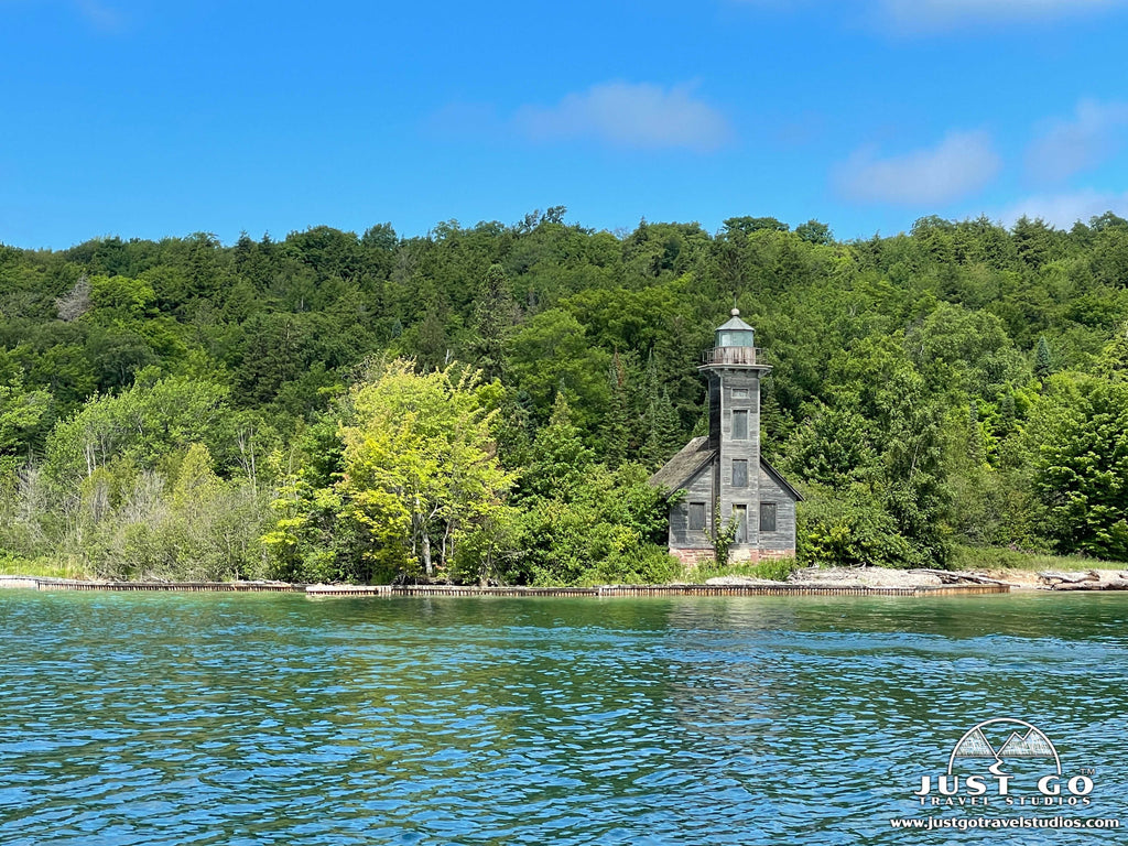
- Au Sable Light Station Trail (easy, 3.1-miles (round-trip), 35 ft. elevation gain)). This short hike is along the shores of Lake Superior to a lighthouse you can only reach by hiking!
- Grand Sable Forest Trail (easy, 2.0-miles (round-trip), minimal elevation gain)). This trail connects the Grand Sable Visitor Center and the Sable Falls parking area.
- White Birch Trail (easy, 2.0-miles (round-trip), minimal elevation gain)). This short trail is an interpretive trail explaining the natural history of the area.
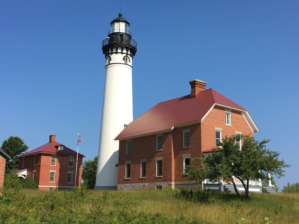
Au Sable Light Station, image courtesy of the National Park Service
THINGS TO DO ON THE WATER AT PICTURED ROCKS NATIONAL LAKESHORE
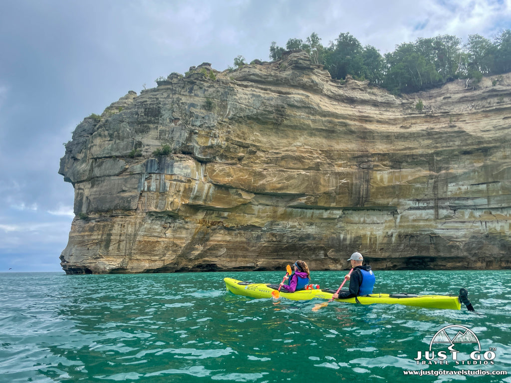
You can see parts of Pictured Rocks National Lakeshore from the land, but the best way to see the unique rock formations and colorful sandstone cliffs is from the water!
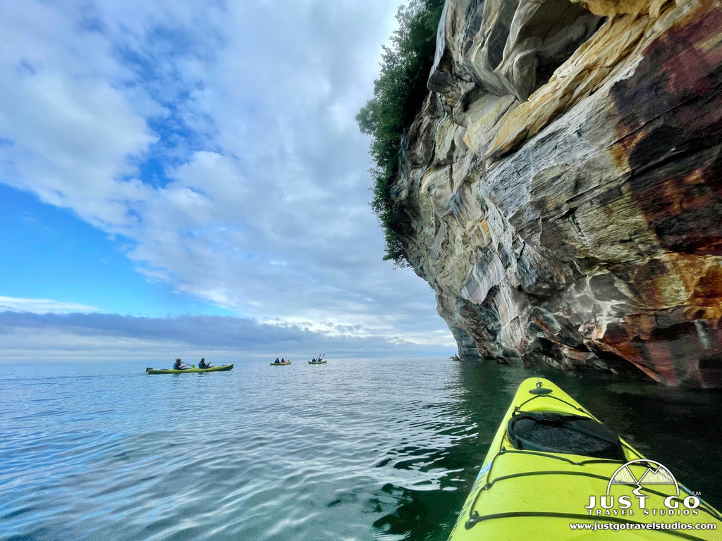
Lake Superior is the largest of the Great Lakes and known for its frigid waters and sudden storms. SUPs, canoes, and recreational kayaks SHOULD NOT be used on Lake Superior. The only type of kayak that should be used on Lake Superior is a sea kayak (with a spray skirt). Unless you are an experienced kayaker with the proper knowledge and equipment for kayaking on Lake Superior, it is safest to use an authorized kayak tour company.
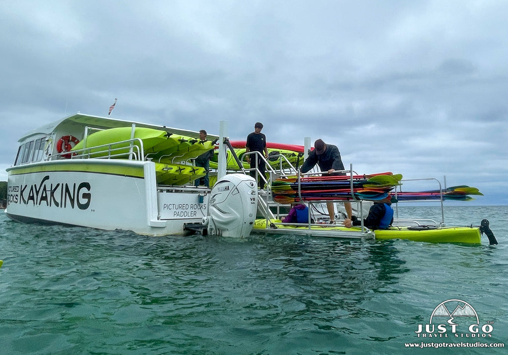
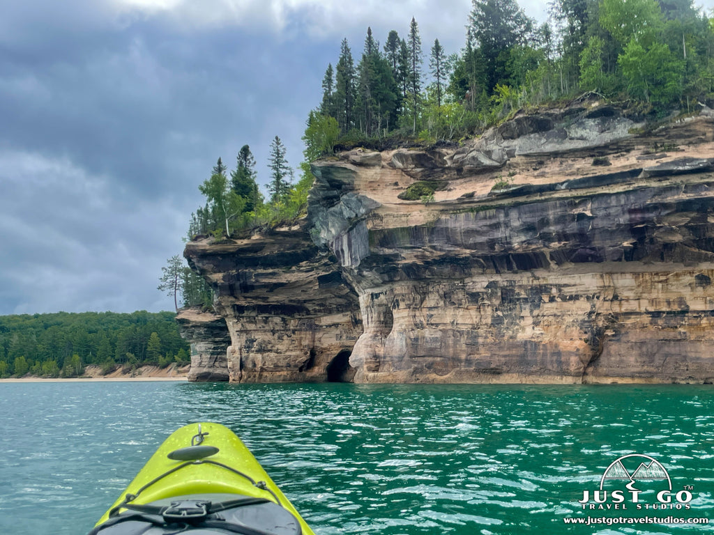
Guided Kayak Tours
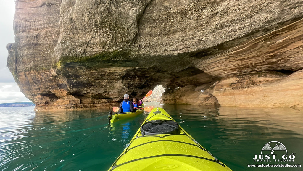
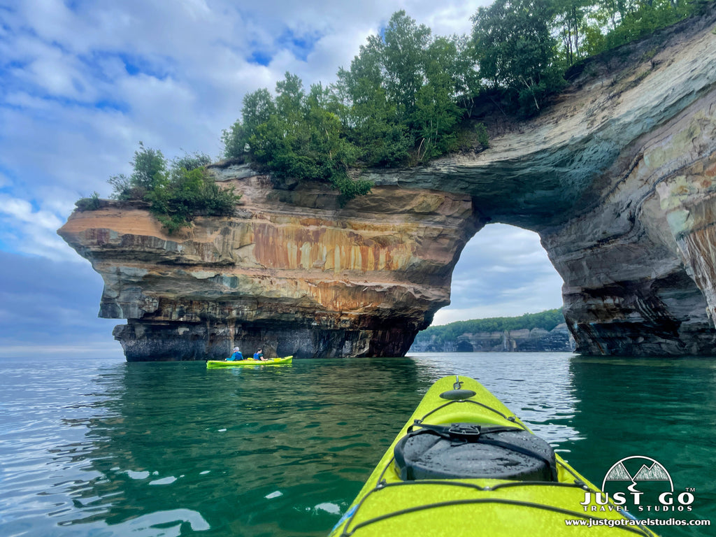
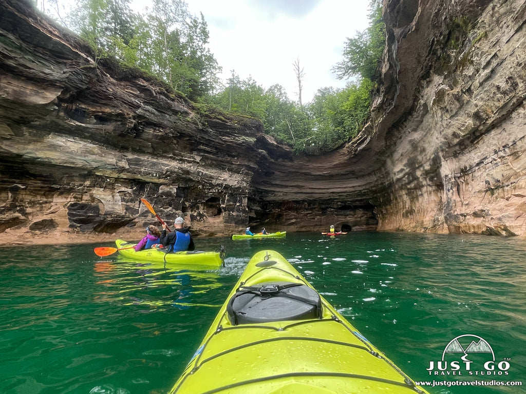
A few local companies based out of Munising offer guided kayak tours suitable for all ages and skill levels. Most kayak tours operate between mid-May and the end of September and range from a few hours to full-day tours (for experienced paddlers). We highly recommend the Ultimate Kayak Tour with Pictured Rocks Kayaking. This 5-hour tour begins with a boat ride to an offshore launch point, passing sights like Miners Castle along the way. Then climb into a kayak to enjoy some of the most picturesque sections of the Pictured Rocks shoreline up-close—from Painted Coves all the way to Chapel Rock! In addition to being a family favorite activity at Pictured Rocks, it was one of the highlights of our entire trip to Michigan’s Upper Peninsula! We recommend booking in advance since tours frequently sell out.

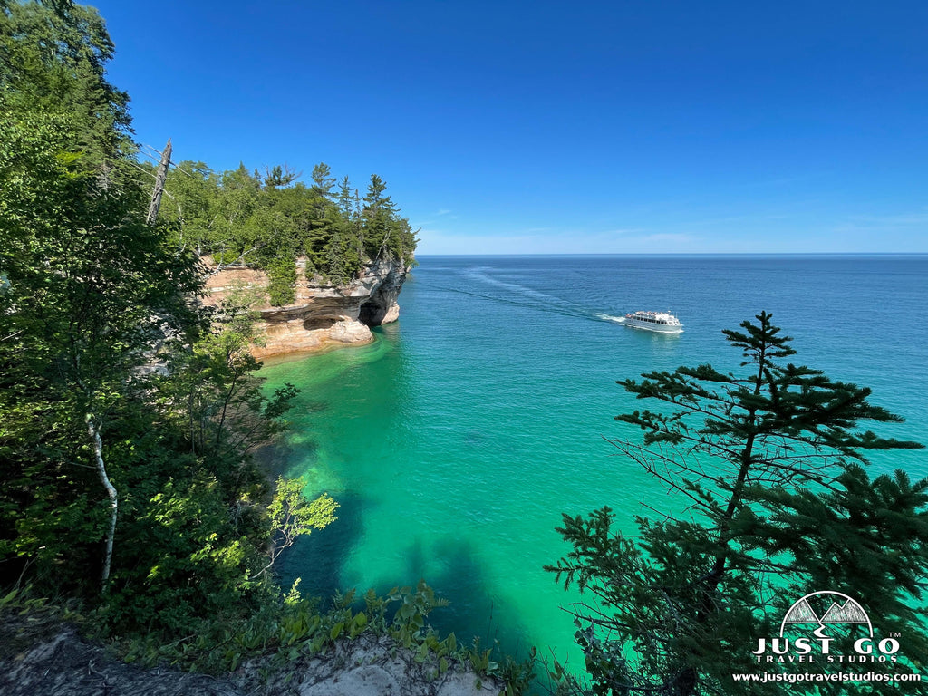
Pictured Rocks Boat Cruises
Taking a boat cruise on Lake Superior is another great way to see the unique features of the Pictured Rocks shoreline. Pictured Rocks Cruises is an authorized NPS concessionaire which offers a variety of cruise options, most 2-3 hours. Cruises operate from mid-May to mid-October and depart from the Munising City Dock. Due to the popularity of boat cruises, they frequently sell out. Purchasing your ticket ahead of time is highly recommended. Seats on the boat are first-come, first-served. During holiday weekends and summer months, arrive 30-45 minutes prior to your cruise time to get in line. Although pets are not allowed on the cruises, we think it is super cool that this company offers complimentary kennels on-site for customers traveling with their pets!
LANDMARKS ALONG THE SHORELINE OF PICTURED ROCKS NATIONAL LAKESHORE
Curious about what you would miss if you skipped a boat cruise or kayak tour?
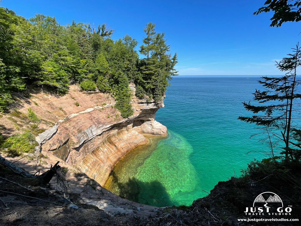
Heading from south to north along the cliffs of Pictured Rocks, Miners Castle is the first major landmark that you will see by water. Yes, this is one landmark you can see quite well from land at the Miners Castle overlooks. In fact, if I am being honest, I preferred the stunning views we had of this feature from land. However, you cannot get a sense for the height of the cliffs or view the sea caves below the Miners Castle unless you are out on the water.
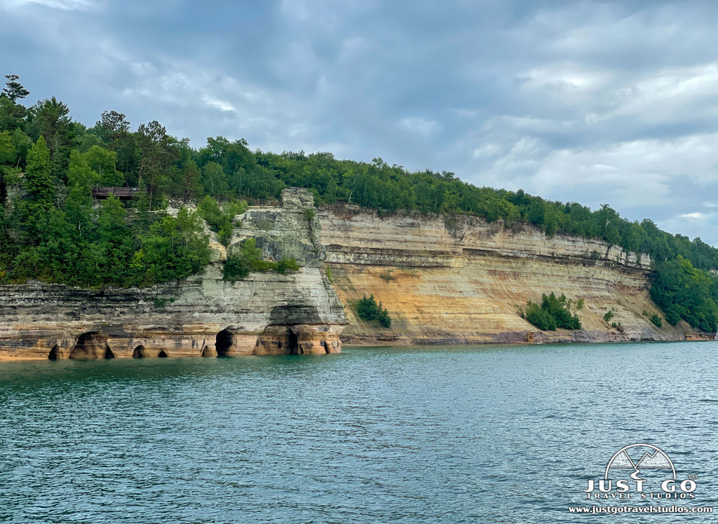
Beyond Miners Castle, you will see the vast sandstone walls of Painted Coves and the mineral-streaked Caves of All Colors that lend the park its name. These ‘pictured rocks’ are a must see!
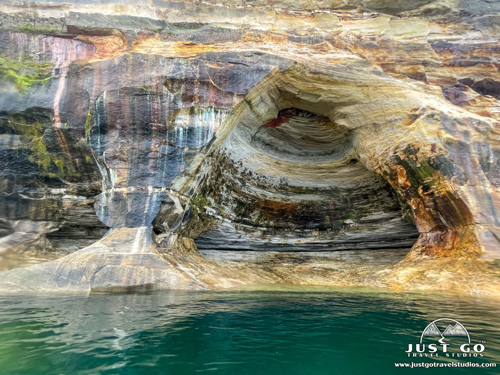
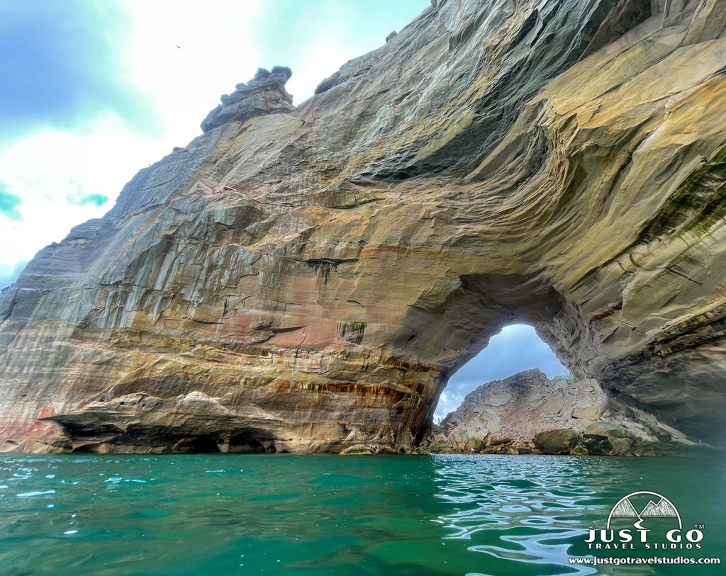
Lovers’ Leap, also called Petit Portal Arch, is a stunning arch that extends from the shoreline to an outcropping in Lake Superior. Rainbow Cave is the largest cave on the Pictured Rocks shoreline. Both Lovers’ Leap and Rainbow Cave are especially fun features through which to paddle if you take a kayak tour!
Indian Head is an interesting rock formation that resembles the profile of a Native American.
Grand Portal is Pictured Rock’s highest point; and, despite rockfalls blocking part of the archway, this massive formation is still super impressive!
The rock outcroppings of Battleship Row resemble the sterns of a row of battleships as they head out to sea.
Flower Vase is named for its likeness to the shape of a vase, with its narrow base and wider, tree-lined top.
Indian Drum consists of three rock formations emerging from the lake and connecting at the top—creating what looks like a drum arrangement for giants.
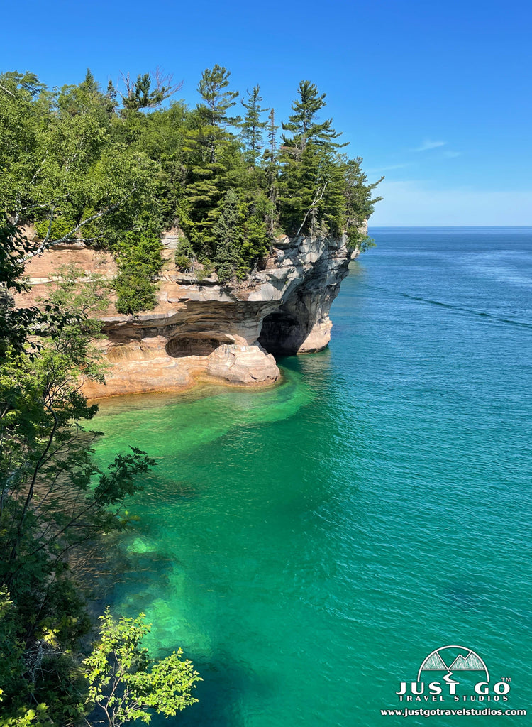
Chapel Cove, a narrow cove surrounded by colorful vertical walls on three sides, is best experienced from the water (one of my favorite spots on our kayak tour)!
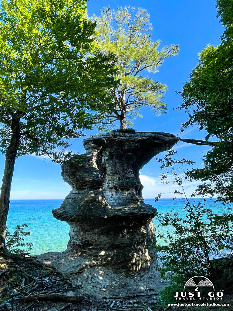
Like Miners Castle, Chapel Rock can be seen well from both land and water; however, seeing it from the water level provides a unique perspective for the rock stack which supports a lone white pine.
WHAT TO DO NEAR PICTURED ROCKS NATIONAL LAKESHORE
If you have extra time while visiting Pictured Rocks, there are some great nearby attractions to explore. Our recommendations include:
- Hiawatha National Forest. With 100 miles of shoreline on 3 Great Lakes (Michigan, Superior and Huron), this vast national forest offers a variety of recreational opportunities. From hiking and fishing to taking a scenic drive and visiting a lighthouse, everyone is sure to find something they love at Hiawatha National Forest! There are also many dispersed campsites, rental cabins, and dozens of campgrounds within the national forest.
- Grand Island National Recreation Area. Grand Island (part of Hiawatha National Forest) is located about a half-mile offshore from Munising in Lake Superior. This national recreation area offers hiking and biking trails, pristine sandy beaches, and numerous scenic overlooks. Tour the island by bus or explore on your own! Visitors can reach Grand Island via passenger ferry, which runs from Memorial Day through mid-October, or private watercraft.
- Seney National Wildlife Refuge. Located about a half hour from Munising, the Seney National Wildlife Refuge is a great place for birders and nature enthusiasts to explore the flora and fauna of this inland area of the Michigan’s Upper Peninsula. Visitors can explore winding roads and hiking trails or go fishing.
HOW TO GET TO PICTURED ROCKS NATIONAL LAKESHORE AND OTHER TRAVEL INFORMATION
There are no major airports near Pictured Rocks National Lakeshore. The region’s largest airport is Sawyer International Airport, located 45 minutes away in Marquette, Michigan. Other airports to consider are Chicago Midway International Airport and Detroit Metropolitan Wayne County Airport, each located about a six-hour drive from Pictured Rocks. No matter how you reach Michigan’s Upper Peninsula, you’ll need a car to get around Pictured Rocks. There’s no public transportation in the park. Since there are loads of great national parks and lakeshores, lighthouses, and other attractions in the Great Lakes area, it makes sense to fly into one of these larger airports. From there you can rent a car and plan a road trip to incorporate some of these amazing stops into your visit to Pictured Rocks!
We drove all the way from New Hampshire to Michigan’s Upper Peninsula. In the area of the Great Lakes, we visited all 3 national lakeshores, 4 national parks, a national monument, and numerous state parks! While in the Munising area, we spent a full day exploring Pictured Rocks by land--including hiking the Chapel/Mosquito Loop, exploring Sable Falls and Beach and driving all the way to Grand Marais. Our second day in the Munising area included the ½ day Ultimate Kayak Tour with Pictured Rocks Kayaking, plus visiting Munising Falls and exploring a bit of nearby Hiawatha National Forest.
We recommend spending at least two to three days to fully experience what this area has to offer. How you spend your time in the park may depend upon where you are staying (in Munising, Grand Marais or camping inside the national lakeshore).
WHERE TO STAY IN AND NEAR PICTURED ROCKS NATIONAL LAKESHORE
The park does not offer any lodging, but there are options to suit all sorts of travelers in towns adjacent to the park—Munising to the west (more popular) and Grand Marais to the east.
Camping inside Pictured Rocks National Lakeshore: Although the park doesn’t offer any developed campgrounds, there are several primitive camping areas (with vault toilets and well water) inside the park. Campgrounds are open from May 15 through October 15. All campsites require a reservation through Recreation.gov and fees are $25 per night. You can read more about camping in the park on our blog on Camping in Pictured Rocks National Lakeshore.
Camping outside Pictured Rocks National Lakeshore: To be based closer to Munising, we chose a campground outside the park. We stayed at Bay Furnace Campground in Hiawatha National Forest, just five miles west of Munising along Lake Superior. This campground is also primitive, but the vault toilets were very clean and drinking water is available. There are no hook-ups, but the campground does have water fill and dump stations. We found this campground family-friendly and very quiet. There is also a beautiful day-use area with picnic tables and access to the lake. Some campsites are first-come, first-served while others can be booked in advance through Recreation.gov. Fees are $22 per night. If you prefer reserving a site ahead of time, be sure to book six months ahead of the first date you’d like to book. Reservations fill quickly for this popular campground!

WHEN IS THE BEST TIME TO VISIT PICTURED ROCKS NATIONAL LAKESHORE?
Pictured Rocks National Lakeshore is open year-round; however, many roads in the park are closed in the winter due to snow. The best time of year to visit depends on what you want to see and do. When the park is fully open (typically between mid-May and mid-October), you’ll be able to experience all the park has to offer—visitor center access, hiking, camping and a variety of adventure activities.
Summer is the busiest time of year at Pictured Rocks, but it is also the best time to visit for outdoor activities like hiking, camping, and kayaking. Expect trailheads to be crowded—the Mosquito/Chapel trailhead sees especially heavy congestion during the summer. Temperatures in the summer typically range from the 60s to mid-70s during the daytime, and nights tend to be chilly (50s) in Michigan’s Upper Peninsula. So, be sure to bring warm clothing. Powerful storms can develop suddenly, so visitors should be prepared for changing weather conditions. Bugs can also be a nuisance in the summer—biting flies are especially bad near the beach. For insects like biting flies (which don’t respond to repellants), we recommend lightweight pants and a long-sleeve top or windbreaker. By late summer, most of the bugs have disappeared since they cannot withstand the colder nights. Late August and early September can be ideal for a visit to Pictured Rocks!
If you don’t mind cooler temperatures, fall is also a great time of year to visit the park. It less crowded than the summer and still perfect for hiking. By late September the colors are just starting to change. Early October is the best time to view the fall foliage.
Late spring is an ideal time to visit to avoid crowds. Although temperatures may still be on the chilly side (40s to low 60s), visitors can catch spring wildflowers in bloom.
VISITING PICTURED ROCKS NATIONAL LAKESHORE IN THE WINTER
Winters are typically cold and snowy at Pictured Rocks and some of the park is inaccessible, due to snow covered roads. However, if you enjoy ice climbing, snowshoeing, cross-country skiing, or snowmobiling, you will love Pictured Rocks in the winter! See the NPS website for more information on winter activities at Pictured Rocks.
Be sure to check the NPS website for current conditions in the park (including road and trail closures).
IS THERE CELLULAR SERVICE IN PICTURED ROCKS NATIONAL LAKESHORE?
Cellular reception is limited throughout the park, but public WiFi is available at the Munising Falls Visitor Center (year-round) and Grand Sable Visitor Center (summer only).
ARE PETS ALLOWED AT PICTURED ROCKS NATIONAL LAKESHORE?
Pets are only allowed in some areas of Pictured Rocks National Lakeshore. They are allowed at all three campgrounds and a few designated trails and beaches within the park. They are NOT allowed on any segments of the North Country Scenic Trail, in the Chapel Basin (including Chapel/Mosquito area trails and beaches) or on the Log Slide or Dunes Trails. Please check the NPS website regarding rules and specific locations where pets are allowed at Pictured Rocks.
Pets must be always kept on a leash no longer than six feet (even on beaches and when swimming). They are not allowed in visitor centers or at public ranger programs. Visitors must clean up after their pets on all NPS land.
IS THERE AN ENTRANCE FEE TO VISIT PICTURED ROCKS NATIONAL LAKESHORE?
Yes, there is a fee to enter the park. Effective March 1, 2022, all visitors are required to have a Park Entrance Pass, which must be clearly visible through the windshield of your vehicle. If you do not already have an America the Beautiful annual park pass, you can purchase a pass for Pictured Rocks online, at a visitor center (during business hours in the summer season) or at the Interagency Visitor Center in the town of Munising.
RELATED INFORMATION ON PICTURED ROCKS NATIONAL LAKESHORE FROM JUST GO TRAVEL STUDIOS
- Before your trip, don’t forget to download a copy of our Pictured Rocks National Lakeshore Itinerary & Hiking Guide and our blog on Camping in Pictured Rocks National Lakeshore.
- Be sure to check out our extensive blog on the Best Hikes in Pictured Rocks National Lakeshore, which also includes hiking maps and more!
- When you return from your trip, check out our custom, vintage travel posters that we make from photos you send to us! We love making them and they are our most popular product!