
Mount Kearsarge Hike in New Hampshire
Peter BrahanIn our humble opinion, the Mount Kearsarge hike is one of the best family hikes in the Dartmouth-Lake Sunapee region of New Hampshire. Located just north of the town Warner, the peak of Mount Kearsarge is conveniently accessible via four different trails. All the trails lead to amazing views from the peak of Mount Kearsarge.
At 2,936 feet, Mount Kearsarge isn’t one of the famed “4,000 footers” in NH, but it has spectacular views. There is also a fire tower at the peak which can be climbed and offers even better views.

The top of Mount Kearsarge is granite, large and quite flat, with views stretching all the way to the White Mountains and into Vermont. And even on days that are crowded, there is plenty of room for everyone to sit around and enjoy the view while you enjoy a snack or lunch.
As a family, we’ve done this hike too many times to count. We first started with the Rollins Trail when we had a 3-year-old hiker and graduated to the steeper trails as our three kids have grown up. Whatever you choose, we are certain that you will absolutely love this hike up Mount Kearsarge!
ROLLINS TRAIL TO MOUNT KEARSARGE

Mount Kearsarge Hiking map (Rollins Trail), courtesy of New Hampshire Parks and Recreation
The Rollins Trail begins at Rollins State Park in Warner, NH. The parking area for the Rollins Trail is accessed by passing the park entrance (accessed via Kearsarge Mountain Road) and continuing up the road until you reach the parking area. The road is steep and windy and sometimes you’ll encounter pedestrians or bikers on the road as well, so be on the lookout.
The parking area can hold roughly 40 cars and can get full on weekend days in the summer by around 9:30 am. Since the hike is relatively short, spots do open up fairly regularly. There are no bathrooms at the trailhead, but there are picnic tables at the trailhead. Since there isn’t any spectacular view here, and the bugs can be pretty aggressive here, we recommend just heading up the trail and eating at the top.
The hike to the top of Mount Kearsarge from here is only about 0.5 miles (1.0-mile round trip total). The elevation gain is just over 300 feet, with most of it occurring in the first 0.35 miles of the trail. There is one place to stop along the way with views to the east if you are so inclined. If you are not an avid hiker, don’t let any of this scare you-it is a really easy hike with only a small amount of rock scrambling at the end. If you are wearing good shoes (sneakers are fine, just stay away from open-toed shoes) then you will have no issues at all.
The only word of caution is that if it has rained recently, the rocks at the top can be a bit slick, so you should be particularly careful if this is the case.

WINSLOW TRAIL AND BARLOW TRAIL TO MOUNT KEARSARGE
WINSLOW TRAIL AND BARLOW TRAIL TO MOUNT KEARSARGE DETAILS
- Difficulty: Moderate
- Distance: 2.7 miles (round-trip)
- Trail: Loop
- Elevation gain: 1,102 feet
- Peak elevation reached: 2,936 feet
- Best time of year to hike: Spring through fall
- To beat the crowds: Arrive before 10:00 am or after 3:00 pm
- Footwear: Hiking boots
- Watch out for: Mosquitoes, sun exposure
- Restrooms: At the trailhead, but none on the trail
- Pets: Allowed on a leash
- Time needed: 2 hours
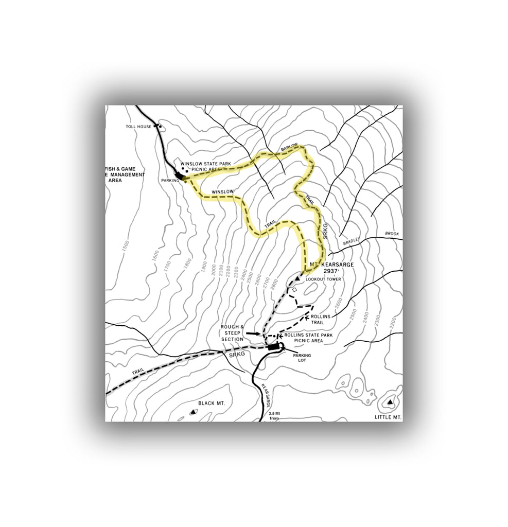
Mount Kearsarge Hiking map (Winslow and Rollins Trails), courtesy of New Hampshire Parks and Recreation
The Winslow and Barlow Trails begin from Winslow State Park in Wilmot, NH. The parking area for the trails is accessed right after the park entrance, which is located at the end of Winslow House Road.
The best way of getting to Winslow State Park if you are coming from Interstate 89 is to take exit 10 and follow the signs to Kearsarge Valley Road and Winslow State Park. The park is about 12 minutes off the highway and can be seen on the map below.
The parking lot is large and can hold nearly 100 cars. However, this is the most popular parking area for accessing Mount Kearsarge hiking, and also is used for those seeking a picnic spot with a view (and without any hiking), as the parking area has great picnicking spots. There is also a small playground to help kids burn off any excess energy they have after hiking (that is, if you are not having to carry them down!). There are bathrooms in the parking lot as well.
The trailhead for both hikes is at the southeastern edge of the parking lot near the trail sign. Both hikes share the same trail for the first 200 feet or so. It is at this point that the trails diverge, with the Barlow Trail heading off to the left (east northeast) at the fork, and the Winslow Trail heading to the right (southeast). Both trails are excellent hikes to Mount Kearsarge for those wanting a bit more of a challenge than the short Rollins Trail. Both climb 1,060 feet, and both end at the same point.

The Barlow Trail is the easier of the two trails, climbing up the mountain over a distance of 1.6 miles (one-way). The incline is fairly steady throughout the hike. The trail heads to a mixed forest, with the last 0.3 miles being exposed hiking on granite.

The Winslow Trail starts off easy before getting fairly steep as it climbs up much more quickly, making the ascent in 1.1 miles. The heavy incline eases up as you get within 0.2 miles from the peak of Mount Kearsarge. This hike is classified as a moderately challenging hike though if you are hiking on a hot or humid day it will feel very difficult for such a short trail.

If you are looking for a loop (for a round-trip distance of 2.7-miles), we recommend hiking up the Winslow Trail and returning on the Barlow trail.
The trails are both well maintained, but you will have to watch your step if it has rained recently. There are also plenty of roots on the trails, providing good grip at some points but also creating a bit of a tripping hazard.
LINCOLN TRAIL TO MOUNT KEARSARGE
Make no mistake, the Lincoln Trail is challenging. if the round-trip distance of 9.4 miles with over 2,100 feet in elevation gain isn’t hard enough, the lack of great markings at the beginning will push it over the edge.
The trail climbs slowly for the first 4 miles before meeting up with the parking lot for the Rollins Trail. From here, you can hike the Rollins Trail to the top (for an easier, but longer summit) or continue on the Lincoln Trail. It should be reiterated that the trail is not well marked and this may inhibit your ability to enjoy this trail.
OTHER TIPS WHEN HIKING MOUNT KEARSARGE
- While we love to hike in New Hampshire, the bugs can be particularly challenging. After late May (and through June), the New Hampshire black flies come out, which can be very annoying and deliver a pretty nasty bite. Mosquitoes are present in the evenings as well during the summer, and on hot summer days, biting flies can find you and love to buzz around your head. The best thing we recommend is repellant, and we recommend the Yaya Mosquito Ban.
- Dogs are allowed on the trails, but they must be leashed. This isn’t enforced heavily, but we’ve had our leashed puppy bitten (and had bleeding) on the trail by another “nice” dog that was unleashed, so please do your part to follow the rules.
- The roots on the trail can really wreak havoc on ankles, so we highly recommend wearing boots.
- When hiking in New Hampshire, we recommend having the NH Hike Safe Card. This is relatively cheap insurance in case you ever need to be rescued from any hike in New Hampshire after being injured or getting lost. The NH Fish and Game Department are experts at rescuing people, but if they find that you were negligent in any way, they will charge you for the rescue, and it can be expensive.
RELATED PRODUCTS FROM JUST GO TRAVEL STUDIOS
- Information on another great spot to check out in New Hampshire can be found in our blog on What to See and Do in Saint-Gaudens National Historical Park.
- After you return from your trip, let us help you remember your hike with one of our custom, vintage-style posters, postcards and note cards using a photo and wording that you send us. We’d love to work with you, and we guarantee you’ll be happy!

ADDITIONAL USEFUL INFORMATION ON HIKING MOUNT KEARSARGE
- Information is also available from New Hampshire State Parks on Winslow State Park and Rollins State Park. The hiking map for Mount Kearsarge is also very useful.

