Lake Chelan Hiking in North Cascades National Park: Trail Maps, Directions & More
Peter BrahanWith the National Parks growing in popularity year after year, it can sometimes be hard to find a good hike that really allows you to just get away from it all. If getting off on your own for a few hours (or even a few days) is something that appeals to you, then you should check out these amazing Lake Chelan Hikes in North Cascades National Park.
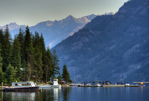
While Lake Chelan definitely takes a bit of effort to get to, it is definitely worth it (and a bit of money) if you can spare the time during your vacation. Even the journey here is amazing by itself. But to really experience the Lake Chelan area, you should get out and hike for at least part of the day.
Lake Chelan is the third deepest lake in the United States, and the work of glacial movement combined with the rise of the Cascade Mountains for millions of years has left behind an amazing landscape to explore.
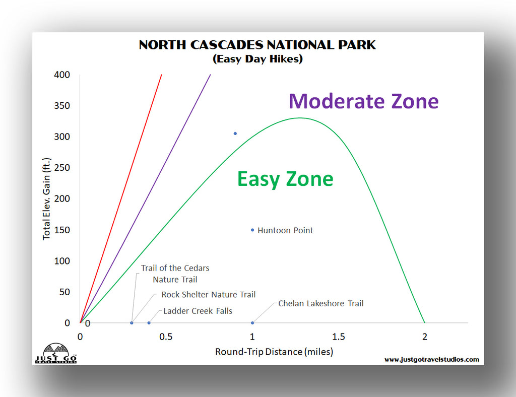
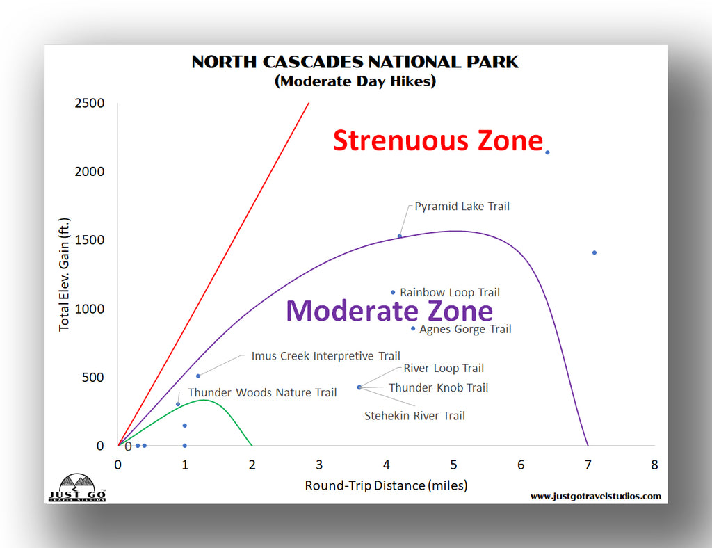
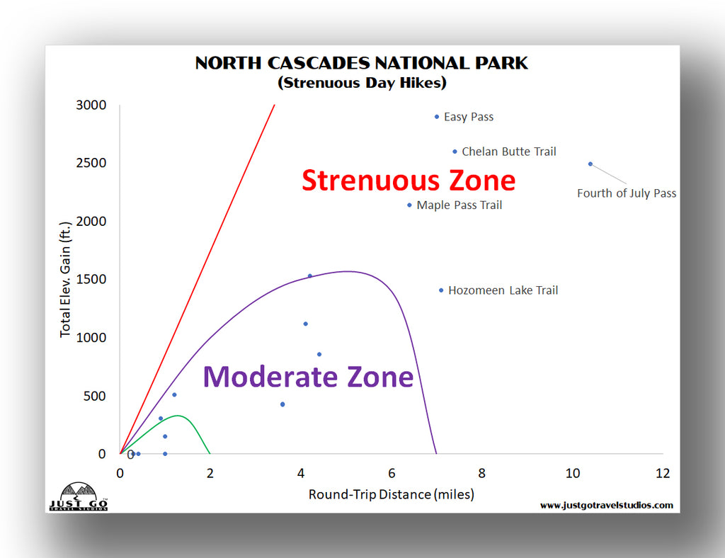
To help out, we’ve plotted out all the hikes in North Cascades National Park in easy-to-use charts. These should help you narrow down the right hike for you and your travel-mates!
Ahead of heading to the Stehekin / Lake Chelan area, be sure to download our itinerary for North Cascades National Park. We cover the best hikes in the park, what to pack, ideas on places to stay and camp as well as what to do in the surrounding area. We help take the guesswork out of planning your trip to North Cascades!
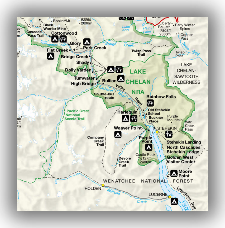
Lake Chelan area map, courtesy of the National Park Service
Even if you only spend a few hours in the area, we hope you are able to experience at least one of these amazing Lake Chelan Hikes!
TRAILS ACCESSIBLE VIA THE LADY OF THE LAKE BOAT SHUTTLE
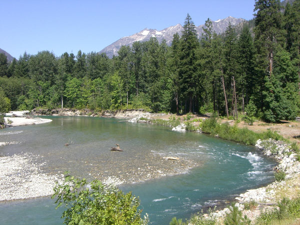
CHELAN LAKESHORE TRAIL
Chelan Lakeshore Trail map, courtesy of the National Park Service
With the potential to be as “epic” of a hike as you want it to be, the Chelan Lakeshore Trail is one of the most traveled trails in the Lake Chelan Area of North Cascades National Park. This hike can be as short or long as you want it to be, ranging anywhere from a short 1 mile round-trip to up to 17-miles (one-way) if you hike the entire route.
If you want to make this an easy hike, just hike the first 3 miles of the trail, which is fairly flat. Or, you can go ahead and continue for the entire length of the trail, which climbs over 2,200 feet in elevation (through a mix of up and down).
The trail hugs the eastern shore of Lake Chelan for the entire length. About 1 mile into the trail is a terrific panoramic view of Mount McGregor, which is to the northwest (looking to the northern end of Lake Chelan).
On this trail there are a few things that you’ll need to watch out for. First, much of the trail is in the open, so be prepared for sun and plenty of exposure to wind, which tends to come down the lake in a stiff manner, especially late in the summer season. We don’t want to scare you, but the other thing to watch out for on this trail are the rattlesnakes. Rattlesnakes won’t bother you if you stay away from them, but they occasionally can be found on or nearby the trail. If you surprise them, they may strike, so just be on the lookout!
It’s common to take the trail one way, heading north from Prince Creek (after being dropped off by the Lady of the Lake) or traveling south from Stehekin. Either way, if you end up hiking the entire length of the trail, you’ll likely want to plan on camping. The camping options include:
- The Meadow Creek Shelter, which is located about 6.9 miles north of Prince Creek.
- The Moore Point Campground is 3.1 miles north of the Meadow Creek Shelter (or almost exactly 10 miles north of Prince Creek). It is also 6.4 miles south of Stehekin. The Moore Point campground is one of the most popular stopping points, as it is a nice halfway stop in between the two ends of the trail.
- There are campgrounds at the northern and southern ends of the trail: Purple Point (to the north) and Prince Creek (to the south).
If you are going to camp in one of these spots you are required to obtain a backcountry permit. You can obtain these through advance reservations (recommended). About 40% of the spots are left for walk-in permits at one of the permit stations. The closest one for the Lake Chelan Ranger Station in Chelan, WA (on the southern end of the lake) or the Golden West Visitor Center in Stehekin.
The trailhead starts at one of three locations: Prince Creek, Moore Point or Stehekin. All three locations are accessed by riding on the Lady of the Lake. After you take the hike, you can then be picked up on the other end. We recommend making reservations in advance of heading out on your hike so you can be sure to have room for you when you are ready to head back home!
Chelan Lakeshore Trail, courtesy of Omarcheeseboro
Hike Option: This trail is full of options, but they are mainly how far you choose to hike on each day. Also, if you end up having some extra energy or time, you can hike from the Moore Point Campground to the east on the Fish Creek Trail. After about 2.4 miles you can continue to miles of backcountry trails or you can head south to Round Lake. The hike to Round Lake from the Fish Creek Trail heads up about 1,300 feet over 1.5 miles. The total hike to Round Lake is 8.0 miles.
AGNES GORGE TRAIL
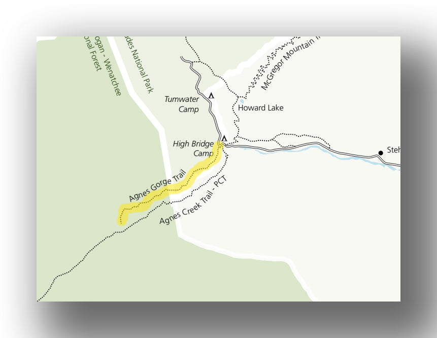
Agnes Gorge Trail map, courtesy of the National Park Service
At the end of Stehekin Valley Road (at the last shuttle stop) are a number of trails, including a junction with the Pacific Crest Trail. Many of them are quite long, but one outstanding day hike is the Agnes Gorge Trail. This 4.4-mile (round-trip) hike travels along the hillside gorge.
After gaining in elevation briefly for the first mile and hiking through the woods (you go up about 300 feet in total during this part of the hike), the trail opens up with amazing views. These views continue along the entire route, with some small ups and downs along the way. In all, you’ll climb about 800 feet on this hike, but most of it is easy and you may not even notice the climbing, since it is also intertwined with some short descents.
Along the entire hike is amazing, but some say the end is the highlight. Agnes Creek flows through the gorge and creates an incredible waterfall that is simply breathtaking. There used to be a suspension bridge that crossed over the gorge here, but that was removed quite some time ago.
Not many people hike in this area, and since this hike takes some effort and time to get to, you won’t see it on the list of “best hikes in Washington.” However, many consider it one of their favorite hikes of all time, due to the serenity, beauty along the entire route and the waterfall at the end. You may even have much of the trail to yourself.
This is a popular hike to take if you are staying at the High Bridge Campground, which is about 0.1-mile from the end of Stehekin Valley Road and 0.1-mile from the trailhead.
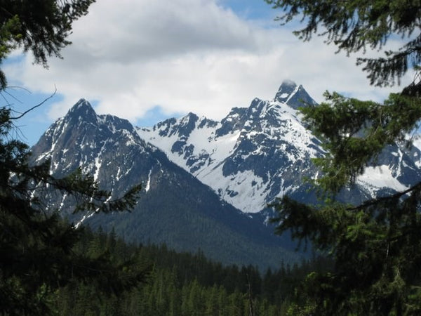
View from the Agnes Gorge Trail, courtesy of the National Park Service
The trailhead starts from the end of Stehekin Valley Road. Hike briefly west (for 0.1 miles) before hitting the junction that leads you to the Agnes Gorge Trail.
RAINBOW LOOP TRAIL
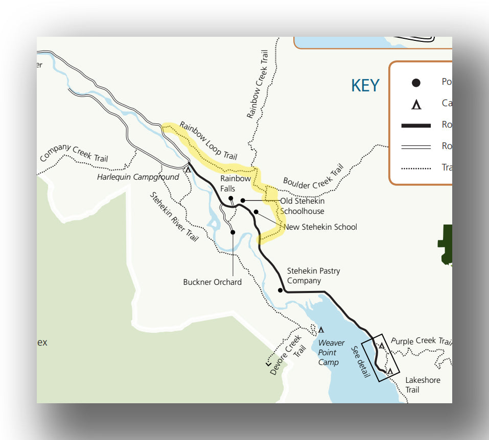
Rainbow Loop Trail map, courtesy of the National Park Service
The Rainbow Loop Trail is actually not a loop. Rather, it is a one-way trail that heads from one shuttle stop north of Stehikin to another, while taking hikers to amazing views along the way. The trail (one-way) is about 4.1 miles, with a total elevation gain of just over 1,100 feet.
The hike is mainly and up and down trail. If you start from the south, you’ll make the incline in about 1.1 miles vs. spreading it out over two miles if you start from the north. About 1.6 miles in from the south, there is a beautiful view of Lake Chelan at a large rock outcropping, followed by a crossing of Rainbow Creek (with a bridge) at about the 1.5-mile point (from the south).
Just south of the bridge is the Rainbow Bridge backcountry campground. This is a beautiful spot, but you do need to have a backcountry camping permit if you are looking to stay the night.
The hike is beautiful, but be advised that there was a fire here in 2010. This means that some of the once lush vegetation is new growth or still charred. While this has impacted the beauty of the hike somewhat, it is still worth heading out on this trail.
The trailhead is accessed by taking the Stehekin shuttle to the southern trailhead (which is about 2.6 miles north of the first shuttle stop in Stehekin) or heading to the northern end of the trail, which is about 5 miles north of the first shuttle stop in Stehekin. Check out the schedule at the North Cascades Lodge at Stehekin. Or course, you need to take the boat from Chelan up to Stehekin to start your journey!
Hike Option: Most people take advantage of the shuttle and make this a 4.1-mile, one-way trip. You can also make it a true “loop” and hike back along the road (which adds 2.4-miles onto the trip). If you are looking for a longer backpacking trip, then head north along the Rainbow Creek Trail when you cross Rainbow Creek, which extends many more miles into the wilderness, with plenty of other trails and campgrounds to explore. About a half-mile south of the Rainbow Bridge Campground is the Biulder Creek Trail. This trail is 9.3 miles long and meets up with the Purple Creek Trail. The Purple Creek Trail then travels 6.3 miles back to Stehekin.
STEHEKIN RIVER TRAIL
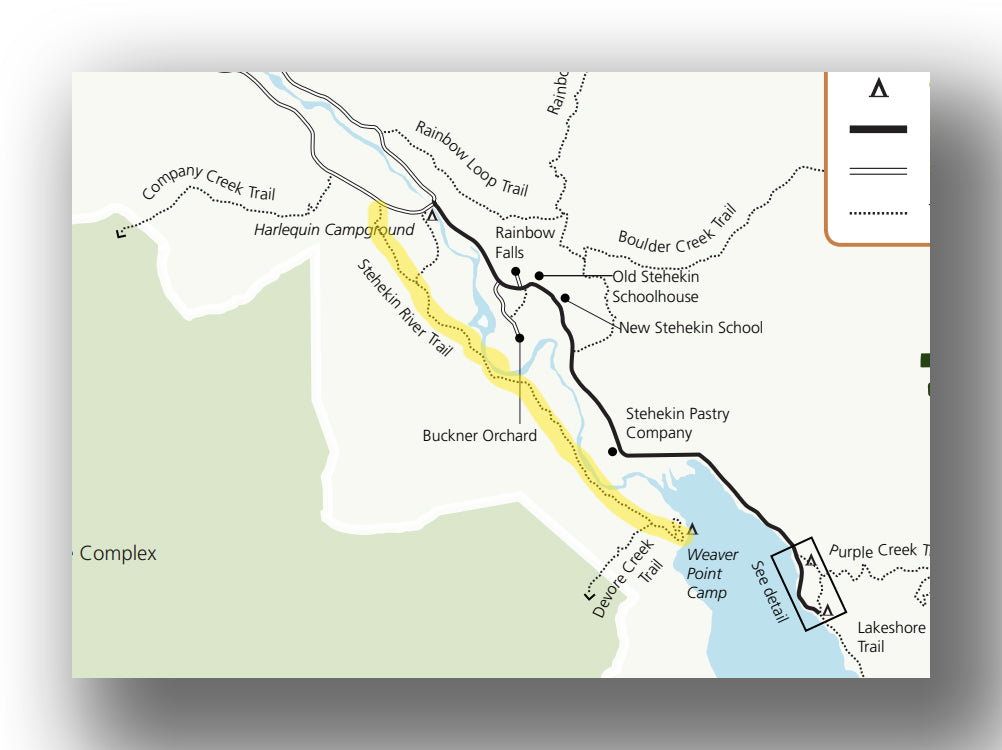
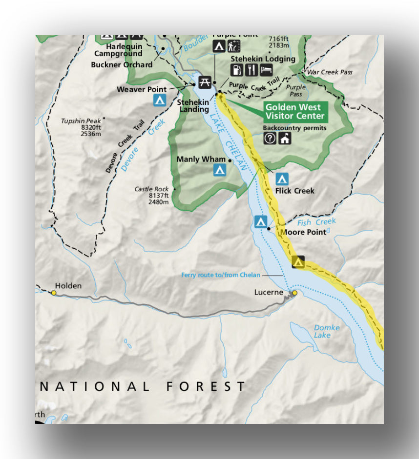
Stehekin River Trail map, courtesy of the National Park Service
The Stehekin River Trail heads south from the airstrip, which is located about 3.5 miles north of the first Stehekin shuttle stop. The trail is relatively flat, with only 420 feet of elevation change over the entire 7.2-mile (round-trip), out-and-back trip. The trail is moderate, with most of the “challenge” happening in the first 1.5 miles.
This trail is fairly easy and very pleasant. It follows close to the Stehekin River, though you will only be right next to the river for a brief time at mile 1.6 and then again starting at the 2.5-mile point. The trail ends at Weaver Point, which also offers backcountry camping. This is a beautiful campground, located right on the shores of Lake Chelan.
The trailhead is accessed by first taking the shuttle to the airstrip shuttle stop. From here, travel west for just over 0.2-miles to get to the Stehekin River Trail.
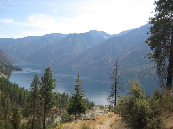
Stehekin River, courtesy of Orygun
Hike Option: If you are feeling like you want an epic trip, after getting to the end of the Stehekin River Trail, head west and take the Devore Creek Trail to the Company Creek Trail back to the airstrip. This is a 23-mile loop. If you take this loop, you’ll want to be prepared for it being at least a two-day journey. However, the views are incredible as well as the solitude.
DOMKE LAKE TRAIL
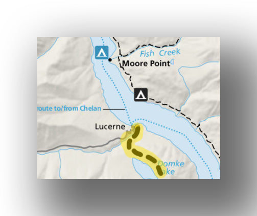
Domke Lake Trail map, courtesy of the National Park Service
The Domke Lake Trail is one of the few trails that is accessed from the west side of Lake Chelan. The trail leaves the small village of Lucerne and climbs up just over 1,300 feet in the first 1.5 miles before levelling out and finishing up at Domke Lake.
The 5.2-mile (round-trip) trail isn’t overly difficult, but the length and elevation gain means that you need to be prepared with plenty of water. There are multiple views of Lake Chelan along the way.
Domke Lake is a great place too cool off and relax prior to heading back. This hike is not overly popular, but it is a must-do if you are staying at the Lucerne Campground.
The trailhead is accessed from the village of Lucerne, which is accessed via the Lady of the Lake.
Hike Option: Combine the Domke Lake Trail with the Domke Mountain Lookout Trail if you want to have a full day of hiking.
TRAILS ACCESSIBLE BY CAR
CHELAN BUTTE TRAIL
There aren’t many trails that are accessible by car that are well-known, but the Chelan Butte Trail is one of them that is located right in the town of Chelan. This challenging 7.4-mile (round-trip) hike climbs over 2,600 feet. Some say this is more of an endurance workout than anything else!
The trail has little to no shade and starts off with climbing immediately. This climb doesn’t stop until you get to the top. There are some steep spots along the way, with little assistance from any switchbacks or areas to rest.
At the top (in particular) are amazing views of the town and Lake Chelan.
The trailhead is accessed from the town of Lake Chelan. Take S. Farnham St. to S. Saunders Street. Turn left on East Iowa Street for about 800 feet. Parking is on the left, but the trail begins on the right side.
OTHER TIPS FOR LAKE CHELAN HIKING
- You likely have noticed, but the Lake Chelan area is remote. While you can find supplies in the town of Chelan and also in the store in Stehekin, you’ll need to be sure you are prepared before even entering in the area.
- When hiking, we recommend you bring plenty of bug spray as well as water, or at water filtration system. Hiking poles or foot traction can also come in handy, seeing as though winter comes early and the snow stays well into the summer in some locations.
FURTHER INFORMATION ON NORTH CASCADES NATIONAL PARK FROM JUST GO TRAVEL STUDIOS
- Ahead of your trip, be sure to download a copy of our continuously-updated itinerary for North Cascades National Park. We include a ton of info to help you get started on your planning, and our guide is helpful while you are in the park too, since cell service is essentially non-existent, particularly in the backcountry.
- Lake Chelan is a great place for hiking. However, there is a soft spot in our hearts for the Maple Pass Loop Trail. This is one of our favorite hikes of all-time and located in the eastern part of the park. Read our blog to check out what you can expect on this trail.
- While there are plenty of great backcountry camping locations in the area, you can also check out our blog on North Cascades National Park campgrounds. We cover the more mainstream campground in the park to help you out with your planning as well.
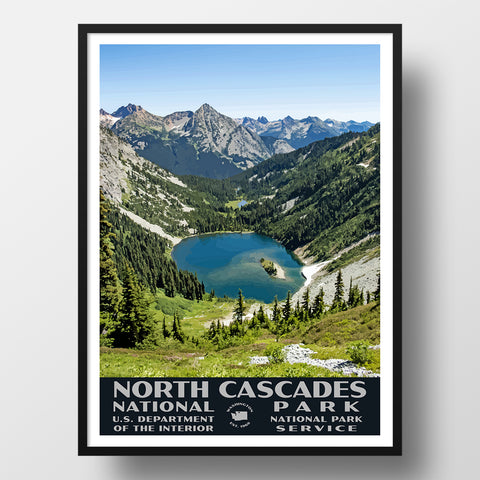
- We have an extensive collection of National Park posters, including our North Cascades National Park poster (WPA style).
- We can also make your photo into a poster-check out how we can create vintage-style travel posters from your own photo!