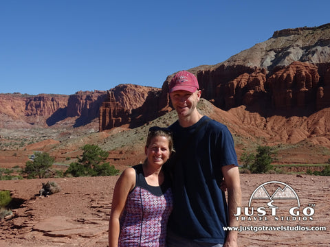
Hickman Bridge Trail in Capitol Reef National Park
Peter BrahanThe Hickman Bridge Trail is one of the most popular trails in Capitol Reef National Park. As one of Utah’s “Big 5” National Parks, is the only park of the five that is geographically by itself. Located on UT-24, just east of Torrey, Utah, Capitol Reef National Park is remote, yet it still drew over 1 million attendees in 2017, even more than Canyonlands National Park, which is only a few minutes north of Arches National Park.
One of the major draws of Capitol Reef National Park is the ease of access by simply driving through it and seeing some amazing scenery without leaving your car. But to really experience and appreciate Capitol Reef, you need to get out and hike, even if it is on a relatively easy trail. The Hickman Bridge Trail is a perfect way to quickly see some of the diversity that this park has to offer and will have you wanting to see more!
HICKMAN BRIDGE TRAIL DETAILS
- Difficulty: Easy to moderate
- Distance: 1.8 miles (round-trip)
- Trail: Out-and-back
- Elevation gain: 406 feet
- Peak elevation reached: 5,746 feet
- Best time of year to hike: Year-round
- To beat the crowds: Arrive before 8:30 am or after 4:00 pm
- Footwear: Sneakers or hiking shoes
- Watch out for: Sun exposure
- Restrooms: Located at the trailhead, but not on the trail
- Pets: Not allowed
- Time needed: 75 minutes
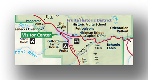
Hickman Bridge Trail Location (from the National Park Service)
The Hickman Bridge Trail is one of many things to do in Capitol Reef National Park, and is highlighted in our 18+ page itinerary for Capitol Reef National Park.
PARKING AND TRAILHEAD FOR THE HICKMAN BRIDGE TRAIL
The trailhead for the Hickman Bridge Trail is located in the Fruita area on Highway 24, just east of the Visitor Center.
- Directions from the Capitol Reef Visitor Center to the Hickman Bridge Trail (this will take less than 5 minutes).
Since the Hickman Bridge Trail is extremely easy to access, and doable even in the heat of the summer, the trail can get quite busy. It is also shared with the Navajo Knobs Trail, meaning that many of the cars may be here for 4-5 hours on that 9-mile trail. The parking area only has about 35 spots. It’s likely that a spot will open up about once every 3-5 minutes during normal traffic times. However, if you want to be sure you get a spot, get here early in the morning!
There are restrooms in the parking area, but there are no restrooms while out on the trail.
HICKMAN BRIDGE TRAIL: TRAIL SURFACE AND ACCESSIBILITY
- Trail surface. Most of the trail is packed dirt and is quite easy to walk on. There are a few spots that are particularly sandy-mostly on level ground, but you still need to watch your step.
- Accessibility. While the trail is not particularly difficult, it is not by any means wheelchair accessible.
THE HIKE TO HICKMAN BRIDGE
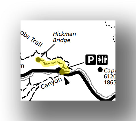
Hickman Bridge Trail map, courtesy of the National Park Service
After you arrive and get ready to hike (and stop at the pit toilet, if needed), the trailhead begins on the eastern side of the parking lot and is well marked. You’ll notice a sign on the left with information about the trail, but the small signs on the right are hard to miss too.
The first sign warns hikers of potential falling rocks. Not only is this possible (but unlikely) near Hickman Bridge itself, but the main worry is in the first 100 feet of the hike as it passes near a rock wall. This area had a rockslide in 2013, which ended up shutting down the trail for nearly a year. This is nothing to be scared about, but definitely don’t take any extra time when hiking through this section!
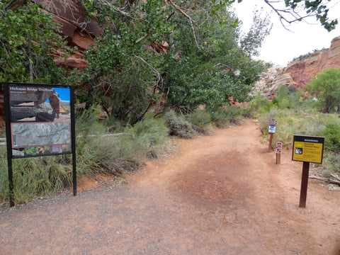
The second sign reminds visitors to not deface any of the rock in the park or you’ll face a hefty fine and potential jail time. Unfortunately, people writing on the rocks is nothing new to Capitol Reef, and is strictly forbidden (as highlighted in this article by the National Park Service).

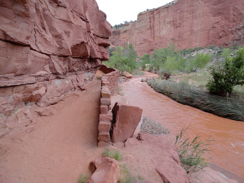
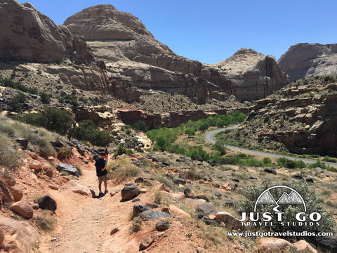
The trail heads along the Freemont River for about two hundred yards before separating and starting to head uphill slightly. Along the way there are nice views of the Fremont River and the lush valley. The Fremont River provides water for the orchards in Fruita, which are a great place to visit after your hike for a quick snack and some much-needed shade.
After turning back to the west and splitting from the Navajo Knobs Trail, the trail climbs for the next quarter mile.

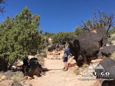
As the trail increases in elevation, amazing views begin to emerge. To the north, you can see Navajo Dome, colored in the classic yellow-beige that is indicative of much of the rock around Capitol Reef.
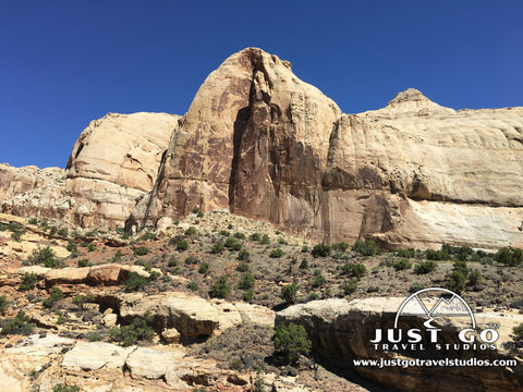
To the south, across the Fremont River, is the distinctive Pectol’s Pyramid, sitting 6940’ above sea level.

These amazing monoliths are just a two of the many such landmarks that you’ll see all throughout Capitol Reef National Park.
The trail is very exposed, and shade is tough to come by, so be prepared with plenty of sunscreen and water, especially if you are hiking in the summer. Our daughter specializes in finding shade, and this was all she was able to find on the way up!

The trail briefly flattens as it enters in the sand wash area. This area is very dry, but it can be overrun with water during rainstorms.

When the trail exits the sand wash, it begins to climb again (though only slightly) as it begins the final push toward Hickman Bridge (approximately 0.1 miles after leaving the sand wash).
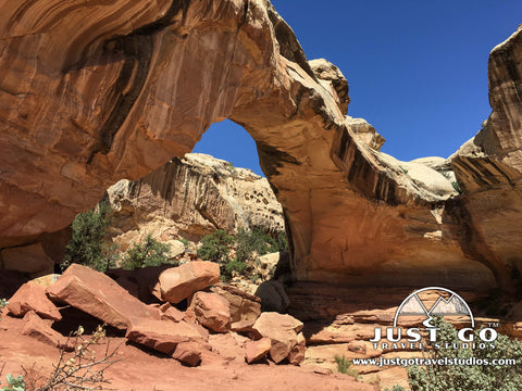
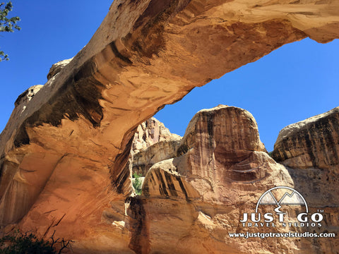
HICKMAN BRIDGE AND THE RETURN TRIP
Hickman Bridge comes upon hikers quickly. Even though this 125’ natural bridge is over 130’ above the ground, the colors of the bridge blend in well with the surrounding area, making it a bit hard to distinguish from a distance (or most of the viewing points). This can make the bridge a bit challenging to photograph due, but against the blue sky it made for some beautiful photos.
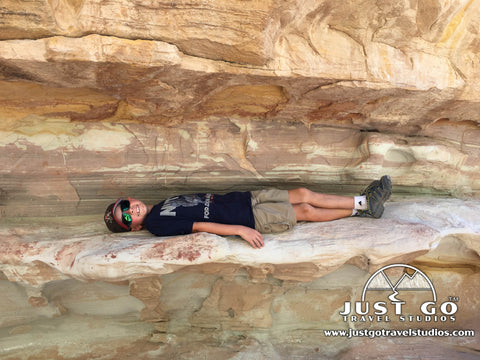
There is plenty of shade in the area around the bridge, and it’s a great spot to hang out and take a break. Though this is a popular hike, finding a spot to sit and relax is not overly challenging. There are even some cool spots that are just the right size for kids too!
As you begin the return trip, the trail continues by looping around to the west for 0.1 mile before rejoining the same trail back to the parking lot. The trip back took about 10 minutes shorter than the trip out.
OTHER TIPS WHEN HIKING THE HICKMAN BRIDGE TRAIL AND IN CAPITOL REEF
- As stated earlier, make sure you head to the trailhead early to beat the heat and the crowds. We hiked the trail in the later part of the morning and were lucky enough to find the last spot, but there were plenty of cars after us that weren’t as lucky. Our blog on How to Avoid Crowds in National Parks might be of use as well.
- Carrying plenty of water is a must. We recommend using a water pack in your backpack, and our favorite is the Platypus Hydration bladder. You’ll want to make sure that you fill up your water at the Visitor Center if you are in need.
- Much of the rock is smooth, but a lot is also very jagged and can cut you if you fall. Especially if you have kids, make sure you bring a first aid kit.
HICKMAN BRIDGE TRAIL: TOP LIKES AND DISLIKES
Likes:
- Ease of Hiking with an Incredible Bridge. This hike is not difficult, and it leads to an amazing natural bridge. Many hikes with similar payoffs in Utah require a lot more work!
- Partial Loop. We love loop trails, as it breaks up the return trip and makes it a bit more interesting. While you can do this trail as an “out and back” trip, we recommend taking the loop at the end.
Dislikes:
- Exposure. Make sure you are prepared for the sun! The trail is wide open and the sun is unobstructed! If you are prepared, though, then it is easy to manage.
FURTHER CAPITOL REEF NATIONAL PARK INFORMATION FROM JUST GO TRAVEL STUDIOS
- The Hickman Bridge Trail is one of many hikes and things to do in Capitol Reef National Park, and is highlighted in our 18+ page itinerary for Capitol Reef National Park. We also included many other great hikes in our blog on the Best Hikes in Capitol Reef National Park. You can also get tips on what to bring on your trip in our blog, What to Pack for Capitol Reef National Park.
- If you are planning to visit other National Parks in Utah, our 60+ page Utah National Park itinerary is available at a discounted price compared to purchasing all the itineraries on their own.
- We create custom, vintage-style posters, postcards and note cards from your photos of Capitol Reef National Park. Check out our process!

OTHER GREAT FAMILY FRIENDLY HIKES AT CAPITOL REEF NATIONAL PARK
Capitol Reef National Park has a ton of hiking opportunities for experts and families alike. Our Capitol Reef National Park itinerary covers the family hikes and their locations. However, we thought it would be beneficial to include information about a few of them here:
Fruita District:
- The fairly easy Cassidy Arch Trail heads through a wash before climbing 607 ft. to Cassidy Arch, which is gorgeous and has a great view. The Grand Wash Trail can also be combined with this hike to extend the trip by 2 more miles. The Cassidy Arch Trail is approximately 3.3 miles.
- The moderately difficult Chimney Rock Trail is a great place to view sunset in particular. The trail is 3.5 miles and is west of the visitor center.
Cathedral District (Northern Waterpocket Fold):
- The Cathedrals Trail is a moderately challenging hike that climbs slightly to incredible panoramic views of the Cathedrals. The total hike is 2.4 miles.
Southern Waterpocket Fold:
- The 2.2-mile Surprise Canyon Trail is a quick out-and-back trail that leads to a deep, narrow canyon that ends at the base of a water runoff.
OTHER THINGS TO DO IN CAPITOL REEF NATIONAL PARK
- The scenic Drive starts at the Visitor Center and heads south for 7.9 miles. This drive is a must-do while you are in the area.
- If you have an off-road vehicle, make sure you head south through the Waterpocket Fold and explore the park to its fullest. As the road heads south, it quickly becomes desolate, so make sure that your car is prepared and you are carrying emergency supplies with you, just in case! The National Park Service has prepared information on road tours that you’ll want to make sure you read about interested.
ADDITIONAL USEFUL INFORMATION ON CAPITOL REEF NATIONAL PARK
- The National Park Service has a lot of great information on Capitol Reef National Park, including maps and information about the geologic features.
- Capitol Reef National Park hiking and camping
- Live and Let Hike has some great information on the Hickman Bridge Trail as well as other trails in Capitol Reef National Park. This site is worth checking out as well!