9 Best Hikes in Shenandoah National Park: Trail Maps, Directions & More
Peter BrahanWhen most people think of Shenandoah National Park, they think of the infamous Skyline Drive. While that is certainly the most accessible and well-known part of the park, the real beauty is found when hiking in Shenandoah National Park. Though the park boundaries rarely veer far from Skyline Drive and the park is quite small, the number of great hikes in Shenandoah National Park is simply astounding. In fact, it’s hard to sort through them all and pick the best hikes in Shenandoah National Park.
But we had to try.
Our list of hikes is by no means all-inclusive, but we did our best to pick the “must-do” trails if you plan on being in the park for several days. And if you are only able to be in the park for a day, don’t fret! Pick any one of these hikes and you won’t be disappointed at all.
We hope that our list of the best hikes in Shenandoah National Park helps you with your planning. If we missed any of your favorites, feel free to leave a comment in the end!
WHICH SHENANDOAH HIKE IS RIGHT FOR ME?
For starters, if you are looking for easy hikes, this chart can help give you an idea of what is right for you:

Most of the hikes in Shenandoah National Park are on the moderate to strenuous side, but the number of options is actually quite surprising. This chart is a bit busy, but it can also give you some tips on some of the other hikes that might be worth considering if you are able to hike a bit more than just on flat surfaces and short distances:

For those interested in the hardest hikes, here are a few to consider:


These hikes and many others are included in our downloadable Shenandoah National Park Itinerary. Our guide will really help you as you plan out your trip, giving you tips on where to stay, details on hiking trails, information on what to see in the area and details on what to pack ahead of your trip. Plus, the fact that the guide is downloadable will give you access to the information even when you aren’t connected to cell service.
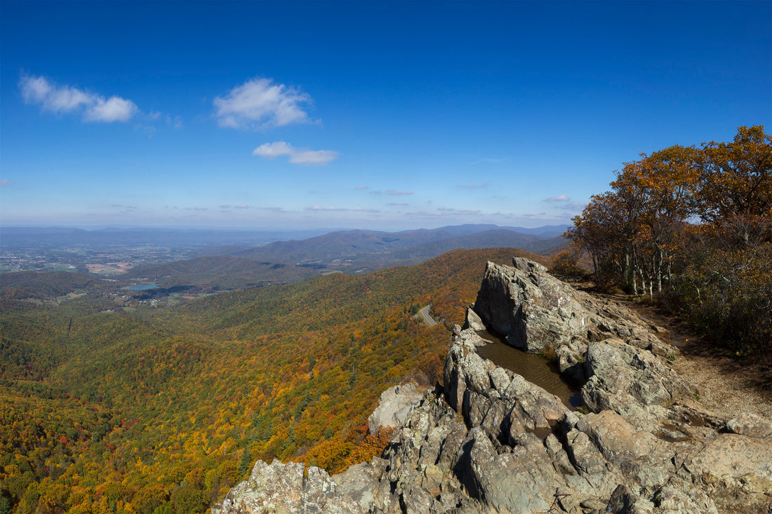
BEARFENCE MOUNTAIN TRAIL

Bearfence Mountain Trail map, courtesy of the National Park Service
One of the most popular trails in Shenandoah National Park is the short (1.1-mile, round trip) loop hike to Bearfence Mountain. This moderately challenging hike takes a bit of scrambling, but rewards hikers with broad, sweeping views. If you are hiking here in the fall, this is simply one of the best trails to take in Shenandoah. There is only about 260 feet of elevation gain.
The trail starts by crossing Skyline Drive. After about 0.1 mile, the trail then meets a junction with the Appalachian Trail. Continue straight (you will return via the Appalachian Trail later), as this allows you to travel up the more precarious side first and go down the more gradual slope of the Appalachian Trail. Be advised that parts of the trail going up are narrow with some drop-offs. If you are afraid of heights or hiking with small children, you may want to just stick to going up and down via the Appalachian Trail.
From the top of the trail, there is an amazing 360-degree view. Because of this, it’s a great place to see sunrise or sunset. If you choose to do that, make sure you bring with you a great headlamp so that you can navigate the rocks safely and don’t have to be rescued, which does happen here on occasion.
Return by heading down the Appalachian Trail. After 0.1 mile going downhill, take a right to head north on the Appalachian Trail back up to the parking lot, about 0.6 miles from this junction. The hike down is a very gradual decline.
The Bearfence Mountain Trailhead starts at mile marker 56.4 on the west side of Skyline Drive.

Bearfence Mountain, courtesy of Lukas Schlangenhauf
HAWKSBILL GAP LOOP (VIA THE APPALACHIAN TRAIL)

Hawksbill Gap Loop Trail map, courtesy of the National Park Service
Another hike with a terrific view is the hike up to Hawksbill Summit, which is the tallest peak in the park. This moderate trail climbs just over 800 feet on the way up to the summit. The entire loop is 2.7 miles.
For the smoothest ascent, head north from the parking lot for a few feet before taking a left on the Appalachian Trail. After about 1 mile, the trail will meet up with Salamander Trail (which turns east). The trail gets slightly steeper from here as it heads up to Hawksbill Summit.
At the summit, there is an observation deck built by the Civilian Conservation Corps, offering views in all directions. This is a great place to view sunrise and sunset, and there is plenty of room at the peak for the large number of hikers that this trail attracts.
Continuing on the loop, the trail heads down the Lower Hawksbill Trail, descending the full 800 feet in 0.8 miles. This is a bit steep, so just take your time.
This is a very popular hike, so make sure you plan on being patient when looking for a parking spot.
The Hawksbill Gap Loop Trailhead starts from the Hawksbill Gap parking area at mile marker 45.5.

View from Hawkbill Summit, courtesy of Paulo O
Hike option: There are two main options to consider.
OLD RAG MOUNTAIN LOOP

Old Rag Mountain Loop Trail map, courtesy of the National Park Service
Even though this hike is definitely rated as “challenging,” the Old Rag Mountain Loop is certainly one of the most popular trails in Shenandoah National Park. With nearly 2,500 feet of climbing, stepping over boulder after boulder near the top and a round-trip distance of 8.6 miles, this trail will both tire you out and amaze you with incredible scenery.
After departing the parking area and heading west for 0.9 miles, the trail meets a junction. From here you can head left for the steeper incline (on the Ridge Trail) or right (on the Weakley Hollow Trail) for a bit of an easier ascent. Though steeper, most people opt to go left so that the hike is a bit easier on the knees when heading down.
Over the next 2.7 miles, the Ridge Trail climbs nearly 2,000 feet. Though aided by a set of switchbacks, the trail is steep and requires bouldering for about a mile before reaching the summit. Surprise! From here the views are amazing and make the climb every bit worth the effort.
After the summit, head down the Saddle Trail for 1.8 miles before reaching the junction with the Weakley Hollow Trail, which travels back downhill (slowly) to the parking area.
Though the distance may not seem that long, plan on this hike taking the better part of a day. Most take 5 to 7 hours to go the full loop due to the amount of time it takes to get through the rock scrambling.
The Old Rag Trailhead is at the end of Nethers Road / Highway 600 on the east side of the park (and is accessed through the town of Nethers, VA, outside the park. For additional details on the hike and a story about a great experience and what you can expect, check out the blog from Maps Without Roads on hiking the Old Rag Mountain.

View from Old Rag, courtesy of the National Park Service
WHITE OAK CANYON TRAIL

White Oak Canyon Trail map, courtesy of the National Park Service
The White Oak Canyon Trail is not easy, but if you can make it the distance, you’ll feel very accomplished and have some great sights along the way! This trail has over 2400 feet of elevation gain throughout the trail, but if you leave from Shenandoah National Park (and Skyline Drive) like most people do, the first half will be easy as it is all downhill.
Leaving the parking lot and heading east, the trail meets up with the Robinson River at the 1.1-mile point. The trail follows the river for the remainder of the distance. The main attractions are Upper White Oak Falls (at mile 2.2) and Lower White Oak Falls (at mile 3.4). We recommend turning back here, but some people hike all the way to Weakley Hollow Road, which is outside the park and makes the hike 9.5-miles long (round-trip).
The footing is not great on all parts of the trail and can be slippery, so be sure you are prepared with proper footwear.
The White Oak Canyon Trailhead starts at the White Oak Canyon parking area at mile marker 42.6 on Skyline Drive.
COMPTON PEAK TRAIL (TO EAST AND WEST PEAKS)

Compton Peak Trail map, courtesy of the National Park Service
The Compton Peak Trail is the first major mountain trail that visitors come to when traveling from the north. It is a relatively short trail, coming in at only 2.4-miles (round-trip). This moderately difficult hike heads up to both the East and West Compton Peaks, which have very good views, though not as good as the views from some of the peaks to the south.
After hiking on the Appalachian Trail for about 0.8 miles, the trail reaches a junction. To the left is Compton Peak East, and the right leads you to Compton Peak West. Both are worth going to, but make sure after you visit the West Peak that you continue a few hundred yards to the overlook. This has great views to the north and is worth checking out. Near the East Compton Peak is the Columnar Jointing, which is an interesting rock formation resulting from fractures that occurred when the rock cooled.
This hike has 640 feet of climbing, which involves going up and down several times as you summit and descend from both peaks. At no point in the trail is it steep, but we do recommend wearing hiking shoes, just to be safe.
The Compton Peak Trailhead starts at the Compton Gap parking area at mile marker 10.4.

Columnar Jointing at the East Peak
Hike option: If you have two cars, consider continuing 1.3 miles on the Appalachian Trail to the next parking area to the south.
OVERALL RUN FALLS TRAIL

Overall Run Falls Trail map, courtesy of the National Park Service
Going to Shenandoah National Park in the spring and early summer is a great time to see waterfalls, and the Overall Run Falls trail allows you to get up and close to a set of cascading waterfalls.
Starting off on the Traces Trail, the hike descends nearly 1,000 feet along Matthew Arms Road before turning left briefly on the Tuscarora-Overall Trail. The hike to the falls is a 5.1-mile out-and-back hike (round-trip) and contains a small amount of hiking on rocky surfaces. If you happen to take this trail in the fall, expect great colors but not a lot of running water (if any).
Though the falls aren’t particularly large, this is a great place to explore in the woods.
The trailhead for the Overall Run Falls Trail starts at the Matthews Arm Campground registration parking area (at mile marker 22.2).
Hike option: You can extend the hike by about 6.7 miles if you continue past the falls for 2 miles. Here you can turn left (south) and hike 4.7 more mils back to the beginning of the hike. Most of this part of the hike is fairly flat, except when you get about 2.5 miles from the end and have to climb back up to the elevation that you started at.
RIPRAP LOOP TRAIL

Riprap Loop Trail map, courtesy of the National Park Service
The Riprap Loop trail is a great hike, but you need to make sure you plan to have plenty of time to hike when you take on this 9.3-mile loop. It includes walking along a river as well as the famous Chimney Rock.
Starting to the south (clockwise), the hikes starts off on the Appalachian Trail for the first 2.2 miles. At this point, the hike goes off to the west on the Riprap Trail and descends. When it turns north, you are along a river for about a mile before heading uphill for most of the remainder of the hike. At the northernmost point is Chimney Rock.
The entire hike has over 2100 feet of elevation gain and some of the trail can be wet and rocky. Be sure to wear proper footwear!
The Riprap Trailhead is accessed at the Riprap parking area at mile 90 orr by accessing the Wildcat Ridge Parking area at mile 92.1.
LITTLE STONY MAN LOOP TRAIL

Little Stony Man Loop map, courtesy of the National Park Service
The Little Stony Man loop trail is a moderately challenging 3.4-mile loop spread across multiple trails. Since it only has a total elevation gain of 948 feet, it is a great hike for those that are more capable than some of the easier trails in the park, yet still want something that’s very doable in about 2 hours.
Starting from the parking lot and traveling clockwise, hikers start off by climbing on the Appalachian Trail. The hike passes by Little Stony Man rockface before the 1.0-mile point, where you follow the signs to the Stony Man overlook. Here you’ll start to see a few more people (and, at times, crowds) heading up to the peak from the Stony Man parking lot.
From the top of Stony Man, there are outstanding views of the surrounding area.
After spending some time relaxing at the top, head back down and meet back up with the Appalachian Trail and continue south for 0.4 miles. As you near the Stony Main parking lot, take a right onto the Furnace Spring Trail. This trail descends about 200 feet before you take a right to the Passamaquoddy Trail. You’ll stay on this trail until you get back to the parking lot. The Passamaquoddy Trail skirts alongside the Stony Man peak, yielding fantastic views without many people for the rest of the hike.
The Little Stony Man Trailhead starts at the Little Stony Man parking area at mile marker 39.1.
Hike option: If you are just looking to go up Stony Man, park in the Stony Man parking lot at mile marker 41.7. From here, it is only a 1.6-mile round trip hike to Stony Man.
TURK MOUNTAIN TRAIL

Turk Mountain Trail map, courtesy of the National Park Service
The Turk Mountain Trail is a moderately challenging hike located in the southern part of Shenandoah National Park. If you are coming into the park from the south, this is a great trail to consider as your first hike of the day if you don’t mind a little bit of elevation gain.
From the parking lot, the trail heads west, descending about 150 feet in the first 0.6 miles before beginning to climb again for the rest of the way. This 2.5-mile (round-trip) trail requires a total of 700 feet of climbing, but none of this mostly shaded trail is very difficult. Be advised, however, that the top of the trail is a bit rocky and will require you to be careful and watch where you walk. If you have trekking poles, they do come in handy on this hike.
At the top of the peak, the views are very impressive. You won’t be disappointed!
The Turk Mountain Trailhead starts at the Turk Gap parking area at mile marker 94.1.

JONES RUN FALLS TRAIL

Jones Run Falls Trail map, courtesy of the National Park Service
If you are here in the spring (when the water is flowing), it’s worth taking the 4.6-mile hike to Jones Run Falls. This moderately challenging hike leads to the 42 ft. falls.
After leaving the parking lot and traveling east, the trail starts to descend immediately. This descent continues for the entire 2.3-mile trip to the falls. The hike down will go fast, with most people getting to the falls in well under an hour.
Once you get to the falls, be sure to rest up, as on the way back you’ll be climbing up nearly 1,300 feet. While this is not the steepest trail in the world, you will definitely notice it in your legs when you get back!
Since it takes a bit of work to get out here, the trail is generally not very crowded, though it can be during weekends and during the busiest times of year. If you are coming here in the drier months, then it’s likely this trail will not be busy at all. Even though you won’t see the water flowing, it is a nice walk nevertheless.
The Jones Run Falls Trailhead starts at the Jones Run parking area at mile marker 84.1.

Jones Run Falls, courtesy of the Mark Levisay
ADDITIONAL INFORMATION ON THE SURROUNDING AREA
- If you are traveling to Shenandoah National Park with kids, then you’ll want to check out this blog on visiting Shenandoah National Park with Kids.
FURTHER INFORMATION ON SHENANDOAH NATIONAL PARK FROM JUST GO TRAVEL STUDIOS
- Be sure to download your copy of the itinerary for Shenandoah National Park. It’s sure to shortcut your travel planning to this amazing park!
- We have a broad offering of WPA style National Park Posters, including a poster of Shenandoah National Park.
- After you get back from your trip, be sure to send us a photos and we’ll turn it into a unique, vintage-style travel poster. This is a great way to commemorate your vacation!

