Yosemite National Park: Things to Do, Hiking Trails, Maps, Fees, Weather & More
Peter Brahan
There is no doubt that there is just something special about Yosemite National Park.
What inspires photographers and travelers from around the world to come here is the same thing that creates large numbers of visitors. Long gone are the days like when John Muir first visited, who got to see this land untouched and without people. Today, Yosemite National Park draws in millions of visitors each year, with about 90% of them visiting only Yosemite Valley. If you come here without a plan, then the one thing you can plan on is being stuck in crowds.
We put together this guide to help you navigate through the park and crowds, to enable you to have the best time possible. We hope that you find it helpful as you work through your trip planning!

Ahead of your trip to Yosemite, we recommend downloading our itinerary for Yosemite National Park. We cover all you need to know about the park, including what to pack ahead of your trip, when to go, the best hikes, sample 1, 2 and 3 day itineraries and all that you need to see and do in the area. Cell service is pretty much non-existent in the park, so this guide will help out with your planning immensely!
YOSEMITE NATIONAL PARK HISTORY
Books have been written on the history of Yosemite National Park, so we won’t try to cover everything here and we’ll do our best to hit the highlights. To see more detail on the history including some amazing pictures, check out the National Park Service Page on Yosemite: Then and Now.
The first Western explorers arrived in the area in 1851. Stories of the amazing Yosemite Valley and the Sequoias spread, and daring, adventure-seeking tourists started to come to the area. Photographers of the era that came to document the wonders produced more than enough content to convince President Lincoln to establish the Yosemite Grant in 1864, which initially protected the land.
Yosemite National Park was established by President Benjamin Harrison in 1890, after years of hard work and influence from those passionate about the beautiful land they had witnessed. It was the third National Park, after Yellowstone and Mackinac National Parks (the latter of the two is no longer a National Park, but that’s a story for another time).
President Theodore Roosevelt first visited Yosemite in 1903, escorted by John Muir. The visit was impactful and helped result in the establishment of five National Parks, 18 National Monuments and countless other federally protected lands under the watch of Theodore Roosevelt during his presidency.
Since the park was created, it’s been expanded many times. The last expansion was in 2016, during President Obama’s tenure in office. Including that expansion of 400 acres, the park now encompasses nearly 750,000 acres of land, including the Mariposa Grove of Giant Sequoias, Tuolumne Meadows, Yosemite Valley, and the Hetch Hetchy Area.
YOSEMITE NATIONAL PARK RESERVATIONS
The reservations system for Yosemite National Park was first implemented during the COVID-19 outbreak in to control the crowds of people descending upon Yosemite Valley. The reservation system has continued since then, and actually has expanded into other parks as well. Don’t worry, though-with a bit of pre-planning, it’s not hard to get a reservation.
Reservations are required if you plan on entering the park on any day in between 6:00 am and 4:00 pm from mid-May through the end of September. There are several different methods of getting a reservation:
- Obtain a reservation for Yosemite on Recreation.gov in advance. This is the easiest and most common method of getting a reservation. 70% of all reservations are opened up in mid-March.
- You can get a “last-minute” reservation on recreation.gov by going online one-week in advance of your stay. 30% of the reservations are available this way.
If you have a reservation for lodging (including camping) or a wilderness permit, you do not have to get a separate park entry reservation.
Of course, if you are an early riser, you can avoid the reservation requirement by getting into the park before 6:00 am. Not only will you not have to have a reservation, it’s also a terrific way of seeing Yosemite in a particularly amazing light!
HOW TO GET TO YOSEMITE NATIONAL PARK AND OTHER TRAVEL INFORMATION
If you are flying into California to head to Yosemite, you have a few options to consider. If you have a few minutes, we encourage you to check out our full article on the closest airports to Yosemite National Park to figure out the right one for you! Here are a couple of options:
- San Francisco, CA is a great airport to fly into. The park is due east of the city (by about 200 miles), and it will take you about 4.5 hours to get to Yosemite. Directions from San Francisco, CA to Yosemite National Park.
- Though not as large of an airport, another option is to fly into Fresno, CA. This shaves off quite a bit of travel time. Yosemite is about 2.5 hours north of Fresno. Directions from Fresno, CA to Yosemite National Park.
The drive is beautiful, but you do have to drive through a lot of farmland on the way east. Be sure to stock up on supplies in Fresno or Modesto before entering into the park. Also, you will have to be sure your car is in good working order, as there is quite a mountain climb on the way to Yosemite. In the summer, this can cause engines to overheat. In the winter, this means that you may need chains. In all cases, check the weather before you go!
GETTING AROUND YOSEMITE NATIONAL PARK – THE YOSEMITE NATIONAL PARK SHUTTLE SYSTEM
Most visitors to Yosemite National Park arrive driving their own vehicles. The independence offered by driving your own car is terrific. However, parking in Yosemite, especially in Yosemite Valley, can be challenging. To help ease the traffic and alleviate the parking issues, the park concessionaire operates multiple shuttles. The most popular is the Yosemite Valley Shuttle, which moves visitors around the Valley, from Yosemite Village to the Ahwahnee and Yosemite Valley Lodge as well as to Curry Village. We recommend using this rather than moving your car when you are in this area.
There are also shuttles that operate in the Mariposa Grove and Tuolumne Meadows.
Schedules, stops and frequency of buses vary by season. For the latest information, we recommend checking out the Yosemite National Park Shuttle page.

Yosemite National Park map, courtesy of the National Park Service
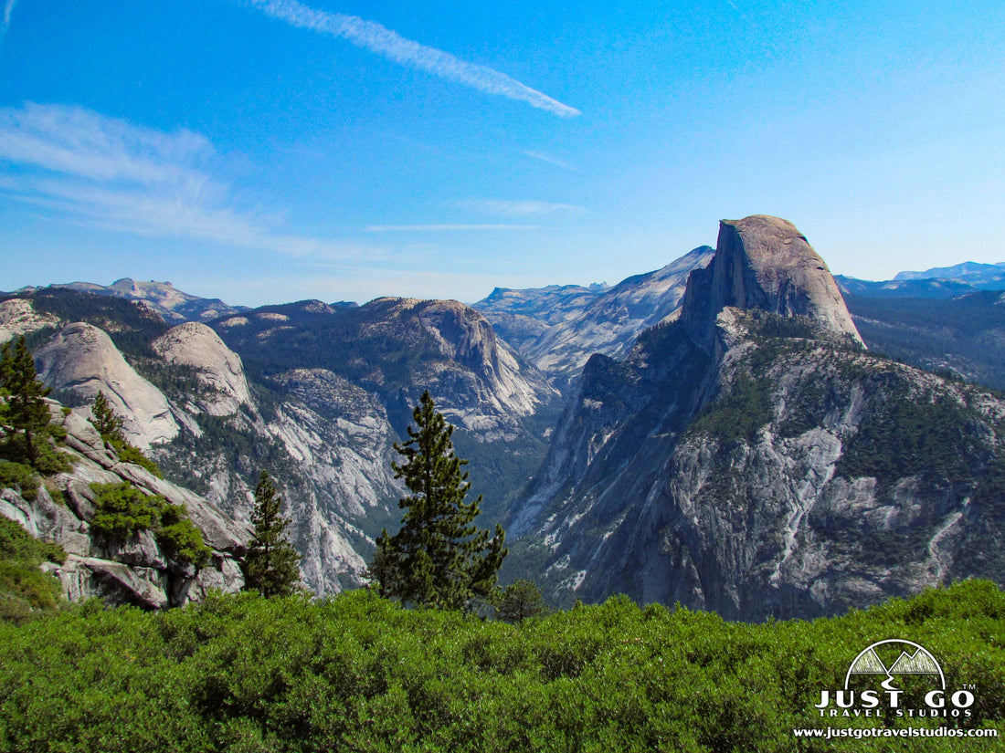
YOSEMITE VALLEY AREA

Yosemite Valley map, courtesy of the National Park Service
If you are visiting Yosemite National Park for the first time, then heading to Yosemite Valley is a must-do. There is a reason why it is so popular. The towering granite cliffs with multiple waterfalls that surround a green valley full of meadows and forest is about as pretty as it gets. For sure, it can be crowded, but don’t even think about skipping this part of the park!

Yosemite Valley is reached from the western side of the park. You can get here by either coming on Highway 120 to Big Oak Flat Road, or from the El Portal Entrance on El Portal Road. Finally, the Wawona Road from the south. Once you get here, the road through Yosemite Valley is a loop. Coming into the valley, there is a one-way road (Southside Drive) that is on the southern side of the Merced River. The loop then turns around once you get to Curry Village and the main parking areas of Yosemite Valley and heads out on (you guessed it), Northside Road.
There is so much to do here, but a few of our recommendations include:
- Yosemite Valley Visitor Center and Theater. Located on the eastern end of Yosemite Valley, this visitor center is the largest and most impressive of its kind in the park. Here you will find access to park Rangers, displays on the history of the park and essentials like maps. There is also a fantastic video in the Theater that takes about 23 minutes.
- Tunnel View. Located on the east end of the Wawona Tunnel (on the west end of the Valley), this is a classic view that is a must-see. It is best in the afternoon / early evening around sunset when the sun is at your back. If it’s cloudy, then it’s great here as well any time of day. Visit Tunnel View as a destination itself or check it out on the way back from visiting Glacier Point and the Wawona areas of the park.

- Rent Bicycles. Yosemite Valley is a bit large if you want to walk it, but it’s perfect for biking. Rentals are available in Yosemite Valley, and there are over 12 miles of paths. You can get them at Yosemite Valley Lodge and Half Dome Village.
-
Hiking. If you really want to see the park, we recommend heading out on foot for at least some of your visit. Yosemite Valley has a broad range of hikes, from short ones that only take about a half hour to multi-day hikes that are strenuous, even in pristine weather. A few of our recommendations include:
- The Vernal Falls via Mist Trail is a moderately challenging 2.4-mile hike (round-trip) that starts off uphill and offers close-up views of Vernal Falls. As you approach the top, you’ll understand why they call it the “mist trail” as you will get wet from the falls. You will also want to keep an eye on your kids, as this trail has stone stairs that get very slippery. This trail does get crowded, and you need to be prepared for the 1000 ft. elevation gain! You can also extend the hike a bit further and go to Nevada Falls. This makes the hike a challenging 6.7-miles (round-trip). After Vernal Falls, the trail heads to Nevada Falls and then you will go down the John Muir Trail. This requires a bit more climbing but is totally worth it (2437 ft. elevation gain). Also, be careful, as there have been known to be deaths from hikers falling (though it is very rare). The trailhead starts at shuttle stop #16.


- Hike to Lower Yosemite Falls on the easy, 1.1-mile (round-trip) trail. There is only about 100 ft. of elevation gain and you get to the bottom of Yosemite Falls. The trailhead starts at shuttle stop #6.
- If you are up for a super-challenging hike, take the trail to Upper Yosemite Falls to see the tallest waterfall in the continental Unites States from the top. This hike is 7.7-miles (round-trip) and climbs over 3300 feet. After leaving the Camp 4 area, the trail heads up, aided by switchbacks. This hike is breathtaking, but be prepared to be tired. The trailhead starts at shuttle stop #7.

- Hiking up Half-Dome may be on your bucket list, but be ready-it’s hard! Climbing over 5200 feet with a round-trip distance of 14.2 miles, this trail starts on the Valley floor before heading up the final push to Half Dome. Permits are required via a lottery system. Even with the permits, the hike is very busy, but it of course has breathtaking views. The trailhead starts at shuttle stop #16.

- For an easy hike, check out the Mirror Lake Trail. This 2.0-mile (round-trip) hike is nearly flat. It’s paved and has views of Half Dome, Tenaya Canyon, Mount Watkins and Washington Column. You can hike to the lake and back, or extend the hike to 5 miles and hike around the lake (the crowds thin out as you go around the lake). This is a busy trail, but is great to go on. The trailheads starts on the far eastern parking lot in the Valley, or shuttle stop #17.
- The Inspiration Point Trail is a moderate, 2.3-mile (round-trip) hike that is lightly traveled, relatively speaking. It leads up to the old viewpoint of Yosemite Valley. The climb is a bit over 1000 feet, but the views are more expansive and private than those from Tunnel View. The trailhead starts from the Tunnel View parking area on the Wawona Road.
- The Bridalveil Fall Trail is and easy, 0.5-mile hike that will take about 20 minutes. This paved trail leads to the base of the waterfall, which flows year-round. Be careful around the rocks at the bottom of the falls, as they are very slippery. This is a very popular hike. The trailhead starts on Southside Drive at the intersection with Wawona Road.

WAWONA (AND MARIPOSA GROVE OF GIANT SEQUOIAS) AREA

Wawona Area map, courtesy of the National Park Service
The Wawona Area is at the southernmost part of the park and contains the Mariposa Grove of Giant Sequoias, which contains over 500 Giant Sequoia trees. It was revamped in 2015 through 2018 for restoration and improvements. Access to the Mariposa Grove is via a free shuttle bus from the parking lot. You should plan on spending at least a half-day exploring this area.
- Wawona Visitor Center and Yosemite History Center. Located just north of the South Entrance, the Wawona Visitor Center has access to Park Rangers as well as an impressive painting display. There is also a History Center, which has historic buildings and exhibits that is worth checking out.
- Mariposa Grove of Giant Sequoias. Take the shuttle bus from the parking area to see these amazing trees. While here, there are several walks / hikes that are worth checking out (covered in the next section).
-
Though not nearly as plentiful as Yosemite Valley, there are some great hikes in the Wawona Area, including:
- One of the best trails around here is the Mariposa Grove Trail. This 7-mile (round-trip) hike has about 1500 feet of elevation gain as it heads by the Fallen Monarch and the Bachelor & Three Graces before reaching the Faithful Couple (two trees that have grown together at the base). It winds through other trees and then provides panoramic vistas of the Wawona Valley. It’s steep at times, but well worth it! The trailhead starts at the Mariposa Grove arrival area.


- The Grizzly Giant Loop Trail is a moderate 2.0-mile (round-trip) hike through the Mariposa Grove. It’s pretty flat, with only 200 feet of elevation gain and includes a visit to the Grizzly Giant, which is the 25th largest Sequoia tree in the world! The trailhead starts at the Mariposa Grove arrival area.

- The Big Trees Loop is an easy, 0.3-mile interpretive trail that tells information about the life of giant sequoias. It includes a visit to the Fallen Monarch, a tree that has been on the ground for 300 years with little decay. It is wheelchair accessible. The trailhead starts at the Mariposa Grove arrival area.

GLACIER POINT AREA

Glacier Point Area map, courtesy of the National Park Service
Sitting across from Half Dome and over 3000 feet above the Yosemite Valley, Glacier Point is a 45-minute drive from Yosemite Valley that is one that you are going to want to take. To get here, head south on the Wawona Road (the fork is near Bridalveil Fall), past Tunnel View and through the Wawona Tunnel. Then then turn onto Glacier Point Road after about 6 miles of driving. The roads here are windy and can be crowded in the summertime, but there’s a reason why so many people head out here!
On the way to Glacier Point, you’ll pass by the Badger Pass Ski area (open only in the winter) and then by several parking areas for hiking before reaching Glacier Point.
The main attractions out here is what most consider to be the best view in the park as well as the incredible hiking. Our recommendations in Glacier Point include:
- Glacier Point Overlook. From here you can see views of the entire Yosemite Valley, including a great view of Half Dome. You can also see the waterfalls flowing. It’s best in the afternoon / early evening or around sunset.


- Washburn Point. Located just south of Glacier Point, Washburn Points has views of Nevada Fall and Vernal Fall in the distance. To really see them we recommend bringing binoculars with you.
-
Hiking. There are a lot of hikes in this area, ranging from relatively short and easy walks to longer day or multi-day hikes. Some of the day hikes that we recommend include:
- A hike with a great payoff without much work is one of our favorites, Sentinel Dome. This 2.2-mile (round-trip) moderate trail winds through a sparsely populated forest on the way to one of the highest domes in Yosemite. The view from the top is incredible (after about 450 feet of climbing). The trailhead starts from Glacier Point Road, about 9.2 miles past the Badger Ski Area.

- If you want a longer hike, then combine Sentinel Dome with Taft Point and make it a loop. This moderate trail (5.1 miles, round-trip) climbs just over 1100 feet. After going to Sentinel Dome, you can continue to the northeast and head on the wooded trail to Taft Point. The trailhead shares the same trailhead as the Sentinel Dome, about 9.2 miles past the Badger Ski Area on Glacier Point Road. You can also just hike to Taft Point, which is 2.4-miles round trip.
- The McGurk Meadow Trail is another great option, and one that is lightly traveled. This 3.5-mile trail (round-trip) heads through wildflowers, which blook in July (the more snow in the year the later they bloom). The Trailhead begins about 2.2 miles east of Badger Pass Ski Area on Glacier Point Road.
TUOLUMNE MEADOWS AREA

Tuolumne Meadows map, courtesy of the National Park Service
One of the quieter spots of Yosemite National Park is the area along Tioga Pass Road on the north side of Yosemite, known as Tuolumne Meadows. It’s a special place with wildflowers, hiking, great camping and amazing solitude if you get out and walk a bit.
Tioga Pass and Tuolumne Meadows is only open in the summer months. You can get here in your own vehicle, which is a great option. Parking up here is generally easy to find. If you are planning on hiking in the area for multiple days, then the Tuolumne Meadows Shuttle Bus is a great option to consider as well.

While up in this part of the park, then we recommend the following:
- Tuolumne Meadows Visitor Center. The visitor center is located right in the heart of Tuolumne Meadows and includes exhibits as well as access to rangers and restrooms.
- Tenaya Lake. Located 7 miles west of the visitor center, Tenaya Lake is beautiful. It’s about a half-mile long and has an amazing backdrop of granite peaks. We recommend visiting in the early morning for the best light.
-
Hiking. Hiking is plentiful here, and you can read about them in detail in our blog the Best Hikes in Tuolumne Meadows. Here are some highlights:
- Hiking. We highly recommend checking out the Cathedral Lakes Trail. This moderate trail (8.5-miles, round-trip) heads up 1500 feet on the way to great views of Cathedral Peak. The trailhead starts at shuttle stop #7, at the Cathedral Lakes Trailhead.

- The Lembert Dome Trail is a 3.8-mile (round-trip) hike with about 920 feet of elevation gain. The trail veers off to the east at the 0.9-mile point and then continues to the peak, which has great views of the meadow and Cathedral Lake. The trailhead starts at the Dog Lake Parking area, which is shuttle stop #2.
- The Elizabeth Lake Trail is a moderate, 4.9-mile (round-trip) trail that gains about 850 feet in elevation, mostly in the first mile. The payoff is a view of Unicorn Peak behind Elizabeth Lake. You can cut the hike short by not hiking around the lake. The trailhead starts at shuttle stop #5, the Tuolumne Meadows Campground.

HETCH HETCHY AREA

Hetch Hetchy Area map, courtesy of the National Park Service
The Hetch Hetchy area is located in the northwestern side of Yosemite National Park. This area is the least visited of Yosemite. The road is only open in the summertime, and only open in daylight hours (usually 8 am to 5 pm). Up here you’ll find the Hetch Hetchy Reservoir, which is the main water supply to San Francisco. It was dammed up by the O’Shaughnessy Dam in 1938. While not a must-do, this is a good respite from the crowds of the rest of Yosemite!
Swimming is prohibited in the Hetch Hetchy Reservoir.
When visiting the Hetch Hetchy area, we recommend the following hiking:
- The Wapama Falls Trail is a moderate, 4.4-mile hike (round-trip) that climbs nearly 1000 feet. It’s up and down most of the way, and starts near the dam and heads on the north side of the Tuolumne River to Wapama Falls. The trail can be pretty damp, so we recommend hiking boots and trekking poles. The trailhead starts right at the dam, and you begin the trail by crossing the dam.
- A hike that is not crowded but is great is the Lookout Point Trail. Thi 2.7-mile (round-trip) hike heads to Lookout Point, which offers views of the reservoir, dam and waterfalls. The trailhead starts just past the Hetch Hetchy entrance station.

Hetch Hetchy Reservoir, image courtesy of King of Hearts
WHERE TO STAY IN YOSEMITE NATIONAL PARK
Yosemite National Park Lodging: There are several options to choose from if you are looking at staying in the park. If you want a traditional, full-service hotel, then there are two in the valley (The Ahwahnee Hotel and Yosemite Valley Lodge). Both are in incredible landscapes. The Wawona Hotel is south of Yosemite Valley (near Mariposa Grove).

There are also several cabins and canvas tent offerings. You can read about all the lodging in Yosemite National Park on the NPS site.
Whatever option you choose, reservations fill up blazingly fast (usually a year), so be sure to book a spot as soon as you know your dates.
Camping in Yosemite National Park: There are over a thousand campsites in Yosemite National Park, spread across 13 different campgrounds. All take reservations, and none offer first-come, first-served camping. Check out the NPS site for more details on camping in Yosemite National Park.
WHEN IS THE BEST TIME TO VISIT YOSEMITE NATIONAL PARK?
Yosemite National Park is open all year, and you really can’t pick a bad time of year to go. If you want to beat the crowds, then visiting in the winter months is the best. But if you want to see the waterfalls at their peak, it’s best to go during May through June.

The weather in Yosemite National Park is usually dry, with hot summers and cool winters. Highs in the summer average around 90°F, and in the wintertime temperatures get into the 20’s on occasion.
The crowds are at their worst in the summer months, like most National Parks in the United States. Visitation creeps up in April and May, and really starts to die down in October and early November.
If you are coming to Yosemite for the first time, then we recommend coming in the summer months and just navigating the crowds by arriving at the park really early in the morning, taking a break in the middle of the day and then heading back in the park as the sun starts to get lower in the sky. The crowds really start to thin out around dinnertime.
VISITING YOSEMITE NATIONAL PARK IN THE WINTER
Heading to Yosemite National Park in the winter can be a magical experience. Seeing Yosemite Valley in the snow is simply breathtaking. You will also be with fewer people than visiting in the summer. However, you can plan on there being snow (and lots of it if immediately following a storm). Even getting into the park can require chains.
If you are visiting Yosemite in the winter, you can expect the following:
- Fewer crowds. Not nearly as many people visit in the winter as are here in the summer.
- Snow covered roads and less parking. Be prepared for your visit by bringing chains. You also need to be ready to have parking areas be crowded with snow, making parking challenging at times.
- Slow waterfalls. Most of the waterfalls are driven by snow melt, and if the snow isn’t melting yet then the waterfalls may just be a trickle or hardly noticeable.
- Potential for winter sports. Yosemite has a small ski area (Badger Pass Ski Area). You can also snowshoe / cross-country ski near the Mariposa Grove.
- Limited access. Glacier Point is not accessible, nor is Tuolumne Meadows, as the roads are not plowed to these locations.
ARE PETS ALLOWED IN YOSEMITE NATIONAL PARK?
- Pets are allowed only in developed areas, in camping areas and on fully paved roads. They are not allowed on any trails. When we visited, we did see this being enforced.
RELATED INFORMATION ON YOSEMITE NATIONAL PARK FROM JUST GO TRAVEL STUDIOS
- Be sure to download a copy of the Yosemite National Park Itinerary ahead of your trip!
- In addition to this blog, we also have articles on What to See and Do in Tuolumne Meadows, the Bridalveil Fall Trail, the Best Hikes in Tuolumne Meadows and Hiking the Sentinel Dome. Also, if you are looking where to fly into when visiting, see our blog on closest airports to Yosemite National Park.
- When you get back from your vacation, send us a photo or two and we’ll create a custom, vintage travel poster. These are excellent keepsakes and we promise you’ll love them!


