Wrangell-St. Elias National Park: Things to Do, Tours, Hiking Trails, Maps & More
Peter BrahanCovering 13.2 million acres of wilderness in the eastern region of South-central Alaska, Wrangell-St. Elias National Park and Preserve is the largest national park in the United States. To get a sense for how vast it really is, compare it to Yellowstone National Park’s 2.2 million acres. Wrangell-St. Elias is SIX times the size of Yellowstone!
The Wrangell, St. Elias, Alaska, and Chugach mountain ranges merge within this expansive park, which also includes nine of the 16 highest peaks in the United States. Wrangell-St. Elias National Park and Preserve is named for the two mountain ranges that form the spine of the park. At 18,008 feet, Mount St. Elias is the park’s high point and the second highest peak in the United States after Denali. Mount Wrangell, with a summit of 14,163 feet, is one of the largest active volcanoes in North America.

In addition to spectacular mountains, Wrangell-St. Elias has the largest concentration of glaciers in North America. 33% of the park is covered by glacial ice! Near the coast, Bagley Icefield, the largest subpolar icefield in North America, feeds multiple glaciers. Hubbard Glacier claims the title of North America’s largest tidewater glacier. Unlike most glaciers which are actively receding, this one continues to thicken and advance towards the Gulf of Alaska. Other notable glaciers in the park include the Nabesna Glacier, the longest valley glacier in North America, and Malaspina Glacier, North America’s largest piedmont glacier.

The scale and remoteness of the park might seem overwhelming. However, it is one of three national parks in Alaska to which you can drive (only three of the eight national parks in Alaska are accessible by road). If you seek a unique national park experience without typical national park crowds, Wrangell-St. Elias is sure to deliver. This wild and rugged landscape is filled with opportunities for outdoor adventure—if you are up for the challenge!
We hope this guide will give you an idea of what to expect when visiting Wrangell-St. Elias National Park and Preserve and help you plan an amazing trip to Alaska!
WRANGELL-ST. ELIAS NATIONAL PARK & PRESERVE HISTORY
In the late 1890s, mineral exploration drew the first pioneers to what is now the McCarthy-Kennecott area. Gold was discovered in 1899 in the northern Wrangell Mountains near the headwaters of the Nabesna River. In that same year, explorers looking for gold found chalcocite ore in the glacial moraine of the Kennicott Glacier. A year later, two prospectors traced the chalcocite to rich deposits of copper ore on Bonanza Ridge.
The discovery of copper ore eventually led to the creation of the Kennecott Copper Corporation. However, the Kennecott mines did not go into production until 1911 when a railroad was completed that would transport the ore 196 miles from the mines to the coastal town of Cordova. The town of Kennecott grew quickly and, in less than five years, became the site of the world’s richest copper mine.

At its peak, approximately 600 men worked in the mines and mill town. The self-contained Kennecott mill town included a general store, school, hospital, and recreation hall, along with other buildings needed for mining operations. About five miles down the road, the town of McCarthy sprang up as a support community for the mill town. McCarthy also provided services that were forbidden in Kennecott, including brothels and saloons.
The mines operated from 1911 until 1938; and, during that time, the railroad transported over a billion pounds of copper ore valued at least $200 million dollars. By the late 1920s, most of the rich copper deposits had been exhausted. Declining profits and the expense of railroad repairs led to the closure of the mining operation in 1938. With railway service also discontinued, most people moved away from McCarthy. Aside from a few remaining residents in McCarthy, the McCarthy-Kennecott area became a ghost town for decades.
In 1974, the Copper River and Northwestern (CRNW) railway was torn up, and the railbed became the foundation of what is now the McCarthy Road. In 1978, Wrangell-St. Elias National Monument was established when President Jimmy Carter designated millions of acres of federal lands in Alaska as national monuments. In 1980, he designated 13.2 million acres of land surrounding the towns of McCarthy and Kennecott as Wrangell-St. Elias National Park and Preserve.
Following its national park designation, the area began to attract adventurous travelers wanting to see the old mines and buildings. McCarthy still has few year-round residents but becomes a hub for tourism to the park during summer months. The town of Kennecott was never repopulated, but in 1986 the area was designated a National Historic Landmark. The National Park Service acquired many of the mill structures and much of the land within the mill town in 1998. Work is still underway to stabilize and rehabilitate some of the old mill town buildings.
KENNECOTT VS. KENNICOTT
Many ask why there are two spelling variations for this Alaskan town. Natural features--the glacier, river, and valley--were all named after naturalist Robert Kennicott and are spelled with an “i.” Man-made features--the mine and mining company--are spelled with an “e.” The confusing part is that town appears to be spelled both ways, and no one can seem to agree about how the spelling of Kennecott came to be! Was the spelling deliberate or a clerical error? Either way, both spellings are still used today.
PLANNING YOUR VISIT TO WRANGELL-ST. ELIAS NATIONAL PARK & PRESERVE
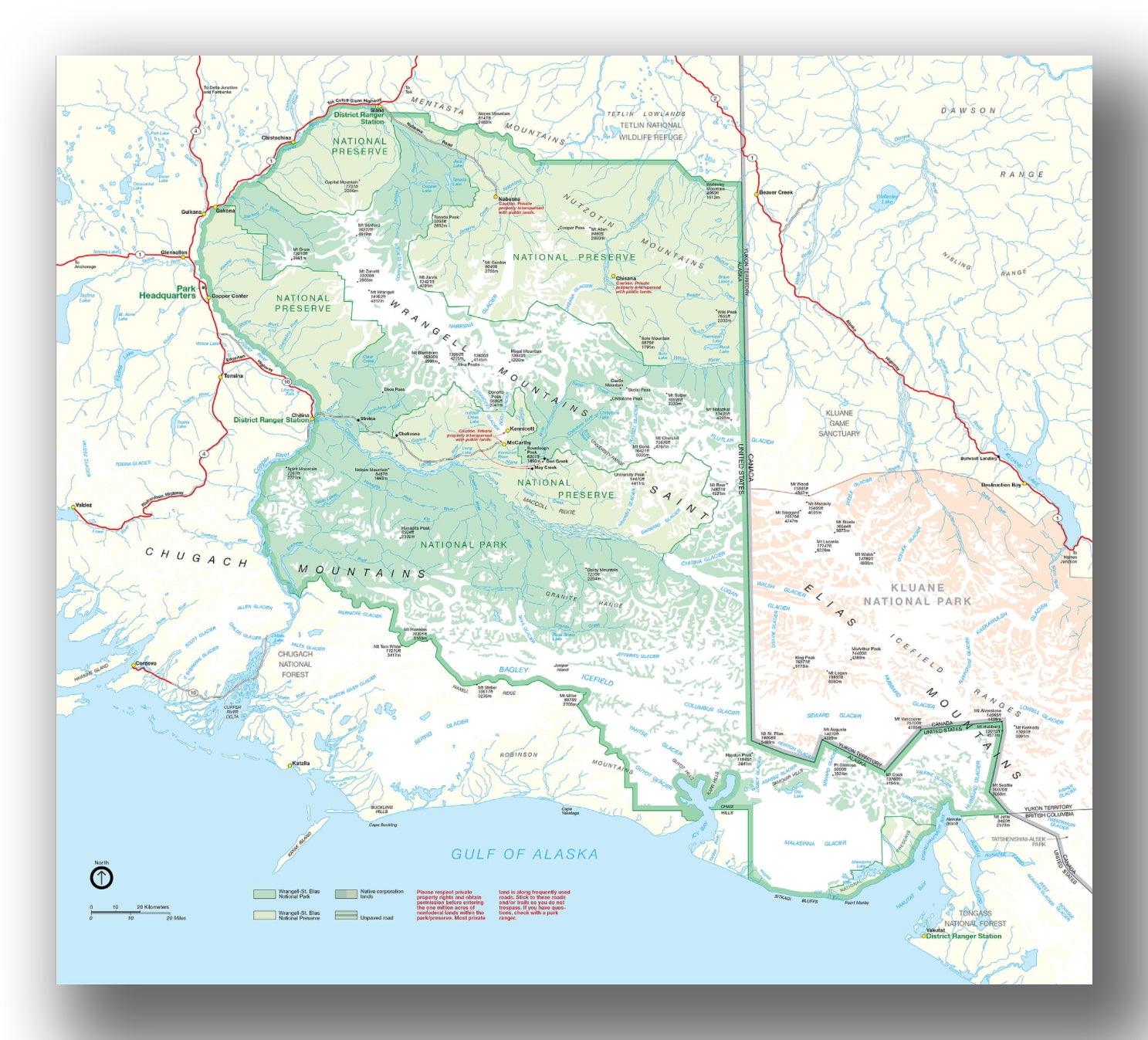
Wrangell-St. Elias map, courtesy of the National Park Service
Since the park is so large, the national park service has divided the park into five areas to help you plan your visit. There are four areas of the park where NPS visitor services can be found—1) the Copper Center area, 2) McCarthy Road and Kennecott, 3) Nabesna Road and 4) Yakutat and coastal areas (only accessible by plane or boat). The fifth and largest area is the vast backcountry of the park—far from any roads or established trails.
COPPER CENTER VISITOR COMPLEX
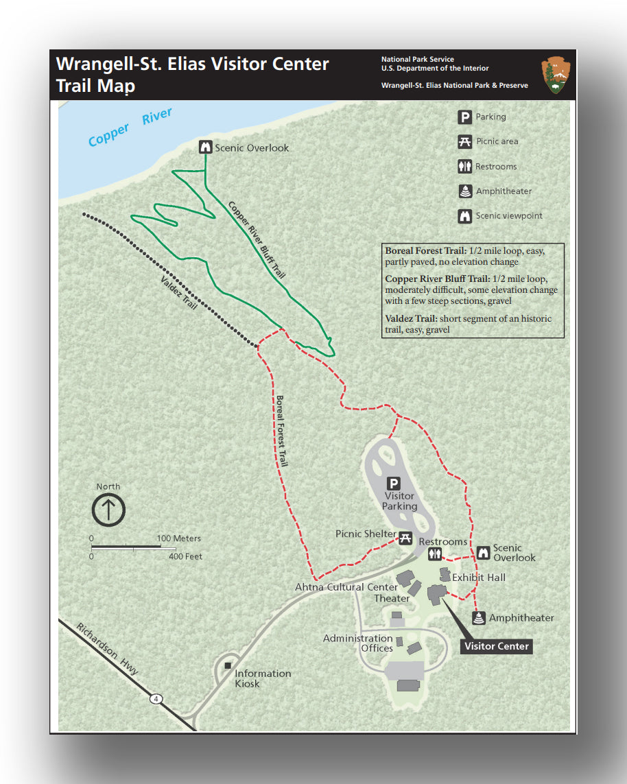
Copper Center Visitor Complex map, courtesy of the National Park Service
Located about 10 miles south of Glenallen and just off the Richardson Highway, the Copper Center Visitor Complex houses the main visitor center for the park. This is also the location of the park headquarters and the Ahtna Cultural Heritage Center (the building next to the visitor center). Be sure to check out the fishwheel on display out front, which was built from spruce logs by an Ahtna Athabaskan elder.

The Copper Center Visitor Center is a great place to begin your journey to Wrangell-St. Elias National Park and Preserve. Access to the park from the Copper Center area requires driving another 3 ½ hours to McCarthy or 1 ½ hours to reach Nabesna Road.
When visiting the Copper Center Visitor Complex, our recommendations include:
- Copper Center Visitor Center. Enjoy the exhibit hall, shop in the bookstore, view the park film or chat with a park ranger. There is also a large picnic shelter near the visitor parking area and a few other picnic tables around the complex. The visitor center is open mid-May to September.

- Hiking. There are three short hiking trails near the Copper Center Visitor Center. Although the visitor center is located just outside of the park boundary, there are some great scenic views of the park from overlooks on these trails.
- The Boreal Forest Trail is an easy 1/2-mile loop through the forest around the visitor center. The trail leads to a scenic overlook with great views of the Wrangell Mountains on a clear day.


- The Copper Bluff Trail is a moderately difficult 1/2-mile loop trail that leads to a scenic overlook of the Copper River and Wrangell Mountains. The Copper Bluff Trail can only be reached via the Boreal Forest Trail, making this a 1-mile loop hike if you do the entirety of both trails. This gravel trail does have a few steep sections.
- The Valdez Trail is a short gravel segment of a historic trail. Much of the original Valdez Trail now lies below the Glenn and Richardson highways; however, this is one of the few pieces that remains.
Use this link for information on other day hikes near the Copper Center Visitor Center (but not located at the visitor complex or affiliated with the NPS).
DRIVING THE MCCARTHY ROAD
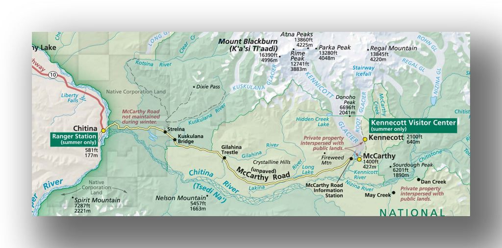
McCarthy Road map, courtesy of the National Park Service
Unless you are flying into the park, McCarthy Road is the gateway into the heart of Wrangell-St. Elias National Park and Preserve. Leave the pavement behind and experience spectacular scenery, historic structures, and possible wildlife sightings on the way to McCarthy! The 59-mile gravel road begins in Chitina and follows the old railroad bed to road’s end, just before the Kennicott River footbridge. Before driving McCarthy Road, stop at the Chitina Ranger Station, located at Mile 33 on Edgerton Highway in Chitina, for road updates and area information. Allow about 2-3 hours (each way) to drive the McCarthy Road and plan to stay at least one night in the McCarthy/Kennecott area. However, we recommend spending two to three days in the park if you plan to take any tours or hikes in McCarthy or Kennecott.
These were a few of our favorite sights and stops along the McCarthy Road (see the NPS McCarthy Road Guide for a detailed list of points of interest along the way):
- Railroad Cut (Mile 0). Just beyond the state wayside in Chitina, the road passes through a granite notch known by locals at the “railroad cut.” The open roadcut you see today was originally a tunnel made to accommodate the CRNW railroad.

- Copper River Bridge (Mile 1). Pull outs before and after the bridge provide views of the confluence of the Copper and Chitina Rivers. On the upstream side of the bridge, watch for Alaskans using dipnets and fishwheels to catch salmon on the Copper River. Mount Drum, the large snow-covered mountain visible to the north, can be seen on clear days.


- Chitina River Scenic Vista (Mile 5). A couple turn outs provide beautiful views of Chitina River to the south.

- Kuskulana Bridge (Mile 17). Located 238 feet above the Kuskulana River, the Kuskulana Bridge is a former railroad bridge that was built in the winter of 1910. The 525-foot-long steel truss railway bridge was rehabilitated with wooden decking and guardrails. NOTE: Yield to oncoming traffic on this single lane bridge and do not stop on the bridge for photos. Pull outs before the bridge provide the best views of the bridge for photo ops. On the southeast end of the bridge, there is a wayside with a picnic table, vault toilets and bear-proof trash bins.


- Chokosna Lake/Lou’s Lake area (Mile 25). Stop for beautiful views of roadside lakes and marshes set against a mountainous backdrop that includes Mount Blackburn.

- Gilahina Trestle (Mile 29). Be sure to stop at this rest area and check out the wooden Gilahina Trestle. The impressive trestle was built in eight days during the winter of 1911! Wandering underneath the structure conjures images of a runaway train on Disney’s Thunder Mountain!


- End of the Road (Mile 59). The McCarthy Road ends here at the Kennicott River. This is where you’ll park your car and start your adventure! Day-use and overnight parking is available for a fee in the large lot closest to the footbridge. Free public day-use parking is available at the McCarthy Road Information Station located at Mile 58.6. No overnight parking or camping is allowed at the information station.


Stay alert for wildlife sightings along the way! We saw bald eagles nesting on the cliffside just before Copper River Bridge, various types of waterfowl in roadside bogs and lakes plus two moose! Other possible wildlife sightings include bear, beaver, trumpeter swans, fox, and porcupine.


McCarthy Road Conditions
Although McCarthy Road is maintained by the Alaska DOT, rough road conditions, potholes and dips in the road are common. We found some of the earlier chip seal sections to be in worse shape than most of the gravel road. In the summer when conditions are good, most vehicles with good clearance can make the trip. Otherwise, a high clearance 4WD vehicle recommended. The NPS does NOT RECOMMEND driving an oversize vehicle such as an RV on McCarthy Road.

Drive slowly and watch for hazards including remnants of old railroad ties and spikes that work their way to the surface and can pop your tires. Traveling with a full-sized spare and jack is recommended. Cellular service is very limited along McCarthy Road so you may not be able to call for help. Know how to change a flat tire.

Most rental car companies in Alaska do not allow you to drive their vehicles on unpaved roads. Your rental car insurance may be voided if you break your contract, and you will be responsible for towing fees and any damage. Be sure to check restrictions before choosing your rental car company. If driving McCarthy Road is on your bucket list, there are a few companies that specialize in renting vehicles to explore Alaska’s gravel roads. We had a great experience renting an SUV from Alaska 4 X 4 Rentals.
Fuel up in Glenallen, Copper Center, or Kenny Lake (Mile 7.1 on Edgerton Hwy) before starting your trip. No fuel or services are available along the McCarthy Road.
For more detailed information about the McCarthy Road, see the McCarthy Road Guide on the NPS website.
VISITING MCCARTHY AND KENNECOTT
There is no vehicle access for travelers beyond the end of McCarthy Road. Grab your things and cross the Kennicott River footbridge. There are hand carts on either side of the bridge to help haul your gear across the river. From the bridge, you can walk, bike, or take a private shuttle (for a fee—cash only) into the town of McCarthy (1/2 mile from the footbridge) or up to Kennecott (5 miles from the footbridge). Shuttles run throughout the day in the summer—typically every 15-30 minutes. Most lodges provide transportation for their guests. Make arrangements for pick-up ahead of time or use the courtesy phone by the bridge to call businesses in McCarthy and Kennecott.


Pete with Hobo Joe, one of the locals
While McCarthy is not technically part of the national park, it is most definitely worth a visit! Walk through the center of town where you’ll feel like you’ve stepped back in time. In McCarthy, you’ll find a few lodging options (one of which is a historic hotel), a couple restaurants, a saloon, a small museum, McCarthy Center store and outfitters that offer a variety of adventure tours in the area.
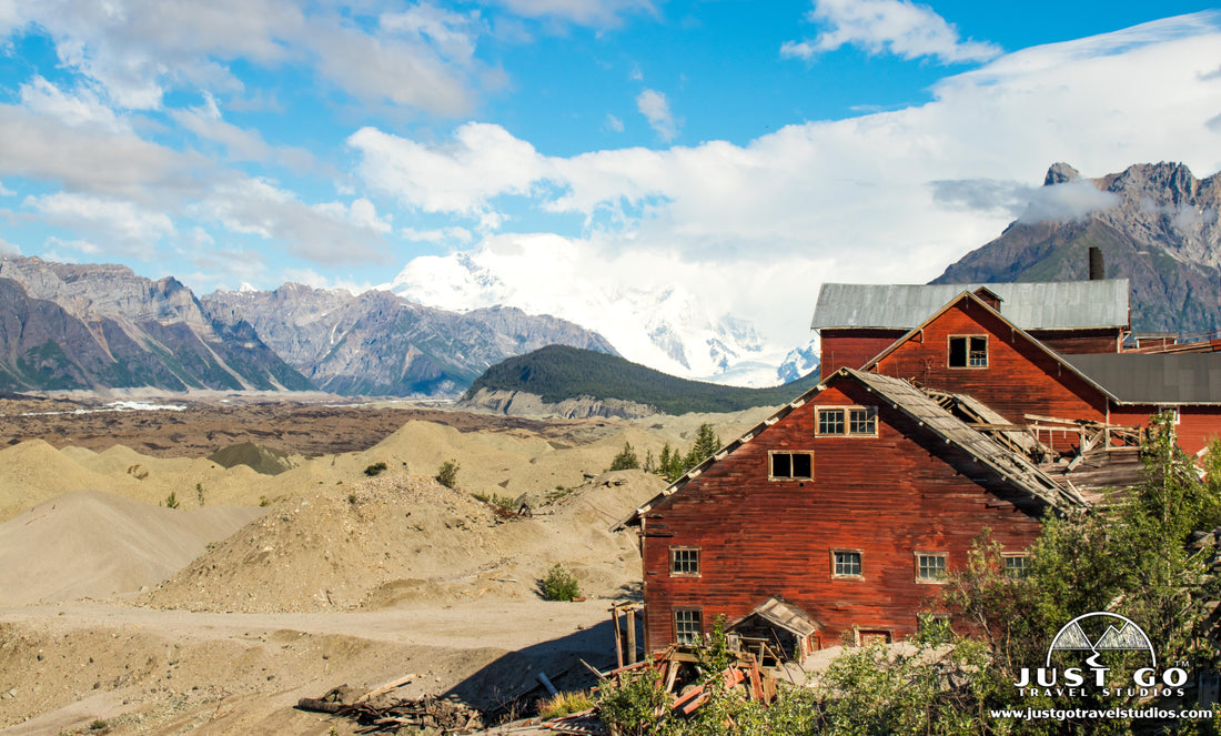
The town of Kennecott is located another 4 miles up the road. The beautiful setting, mining history and proximity to hiking trails make Kennecott one of the major centers for activity in the park. The most eye-catching building in town is the iconic red concentration mill building, which stands 14 stories high. In Kennecott, you’ll also find a visitor center, the historic Kennicott Glacier Lodge (offering hotel rooms and fine dining), a food truck and a gift shop/coffee cart.
When visiting the McCarthy/Kennecott area, our recommendations include:
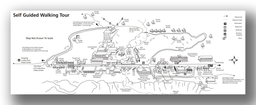
- Kennecott Visitor Center. Housed in Kennecott’s historic Blackburn School, the Kennecott Visitor Center is a great place to start your visit at the Kennecott Mines National Historic Landmark. The small visitor center offers exhibits, a park film (shown upon request in the General Store), seasonal ranger programs, a bookstore, backcountry trip planning, and other park information. It is generally open from Memorial Day to Labor Day.

- Kennecott Mines National Historic Landmark. Designated as a National Historic Landmark in 1986, Kennecott is considered the best remaining example of early 20th Century copper mining. The National Park Service has restored a few of the buildings for modern use, including the store, post office and Blackburn School (now the park’s Kennecott visitor center). However, stabilization work on other buildings in town is expected to take many years. Explore Kennecott on a self-guided walking tour or tour the buildings with an NPS-concessionaire. St. Elias Alpine Guides offers a two-hour Historic Mill Tour, which is the only way for visitors to go inside the 14-story concentration mill.


- Hiking. There are a few popular day hikes in the McCarthy/Kennecott area. Most hikes depart from Kennecott Mill Town. When hiking any area trails, be bear aware and carry bear spray.
-
- The Root Glacier Trail is a moderate 2-mile hike (one-way) that leads to one of the most accessible valley glaciers in Alaska and some pretty spectacular views! Follow a marked trail that crosses creeks and weaves in and out of the forested mountainside before descending the moraine to the toe of the glacier. If you plan to walk on the glacier, crampons are highly recommended. For added safety, we hired a guide since this was our first time walking on a glacier. The guide provided our crampons, led us across the icy terrain and pointed out distinctive features including blue pools, crevasses and moulins. Local guides offer half-day hikes, full-day hikes, and ice climbing on the Root Glacier, plus all the proper equipment for your chosen adventure. Root Glacier Trail access: The marked trail begins on the far side of town beyond the Concentration Mill. Total hike length varies depending on whether you walk onto Root Glacier and how far you explore. Allow 2-6 hours round-trip.


- From the turn for the Root Glacier access trail, you can continue straight on the Erie Mine Trail for another 2.5 miles. The trail winds through forest and along the moraine above the Root Glacier before reaching the end of the trail with great views of the Stairway Icefall. The Erie Mine bunkhouse may be visible high above on the mountainside to the right of the trail. The trail does NOT take you to the actual Erie Mine. Erie Mine Trail access: The trail departs from the mill town and follows the Root Glacier Trail for the first 1.5 miles before the junction with the spur trail to the Root Glacier. Allow 4-6 hours for the 8-mile round-trip hike.
- The Jumbo Mine Trail (10 miles RT) is a strenuous day hike to relics of the Jumbo Mine’s buildings and historical artifacts. The trail is steep and climbs 3,300 feet in 5 miles. Hikers are rewarded with stunning views of the Chitina River Valley and Chugach Mountains to the south. Jumbo Mine Trail access: A marked trail begins on the far side of town beyond the Concentration Mill. The trail to Bonanza/Jumbo Mines splits off to the right from the Root Glacier Trail. Then follow signs to reach Jumbo Mine. Allow 6-8 hours round-trip.
- The Bonanza Mine Trail (9 miles RT) is another tough day hike to remnants of the Bonanza Mine high in the mountains above Kennecott. Be prepared for a steep uphill hike with 3,800 feet of elevation gain in 4.5 miles. Once above treeline, take in sweeping views of the Root and Kennicott Glaciers in the valley below. Bonanza Mine Trail access: A marked trail begins on the far side of town beyond the Concentration Mill. The trail to Bonanza/Jumbo Mines splits off to the right from the Root Glacier Trail. Then follow signs to reach Bonanza Mine. Allow 6-8 hours round-trip.
- While exploring Kennecott, take the 1.5-mile Top of the Mill Trail. This loop trail winds up and around the Concentration Mill and offers a unique perspective of the mill town. Top of the Mill Trail access: At the far end of town, follow signs to Bonanza/Jumbo Mines and then continue onto the trail that winds around the top of the mill and back down into town.
- The Wagon Road is a historic trail through the woods that parallels the road between McCarthy and Kennecott. It offers a nice alternative to walking or biking the dusty 4.5-mile road. Along the Wagon Road, you will pass the old Kennecott cemetery (about a mile from Kennecott). Wagon Road access: Follow the main road north from the McCarthy Museum toward Kennecott for about 1000 feet. Take the first turnoff on the left with a sign indicating the start of the Wagon Road (just past a red and white building).
- The Wagon Road can also be used to reach a rough dirt road that leads to the Toe of Kennicott Glacier, about 1.5 miles from McCarthy. The trail ends at the terminal moraine and meltwater lake of the Kennicott Glacier. Yellow dryas are plentiful here but take care not to step on them due their delicate root systems. Dryas are most impressive after they go to seed. Their wild and feathery seedheads have earned them the nickname, “Little Eintsteins,” for obvious reasons! Toe of the Kennicott Glacier access: To reach the Toe of the Kennicott Glacier, follow directions to the Wagon Road. The trail forks after about .75 miles. Take the left fork to follow a dirt road towards the “toe” of the glacier.


See the NPS website for maps and more information on any of the hikes/trails in the McCarthy/Kennecott area.
- Adventure Tours. There are a few local businesses that offer a variety of tours that start in either McCarthy or Kennecott. Choose from guided hikes, ice climbing, paddle boarding and river rafting. Tours range from day trips to multi-day expeditions and multi-sport adventures. For more information on adventure tours, see the websites of Elias Alpine Guides, Kennicott Wilderness Guides and McCarthy River – Tours & Outfitters.
- Flightseeing Tours. Since Wrangell-St. Elias National Park is so large and only two roads lead into the park, one of the best ways to see otherwise inaccessible country is on a flightseeing tour. McCarthy’s air strip is the starting point for some spectacular flights over numerous glaciers and some of the tallest mountain peaks in North America. Check out Wrangell Mountain Air for your flightseeing options.
- McCarthy-Kennicott Historical Museum. Operated by a dedicated group of locals, this small museum is located in the former McCarthy railroad depot and features historical artifacts, documents and photos from days of copper mining.
- Good eats in McCarthy & Kennecott. In McCarthy, enjoy a delicious meal at the Potato. Their homemade comfort food, plus a great selection of beer, wine and cider, is sure to satisfy your hunger after a day out exploring in the park! Whatever you order, don’t skip the curly fries! While in Kennecott, grab a quick meal at the Meatza Wagon. Enjoy some of the best food inside the park from this food truck with glacier views!

NABESNA ROAD
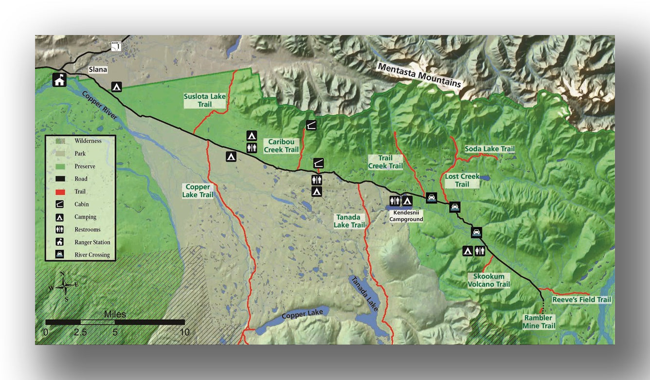
Nabesna Road map, courtesy of the National Park Service
There are only two roads that lead into the park--McCarthy Road and the lesser travelled Nabesna Road. Starting from the Tok Cutoff at mile 60, the 42-mile Nabesna Road provides an opportunity to experience the northern reaches of Wrangell-St. Elias National Park. Nestled in a valley between the Mentasta and Wrangell Mountains, the scenic road offers spectacular scenery plus opportunities for camping, hiking, and wildlife viewing. Allow about 1.5 hours (each way).
We’ve included a list of some places you may want to stop along the way (see the NPS Nabesna Road Guide for a detailed list of points of interest):
- Slana Ranger Station (Mile 0.2). At the start of Nabesna Road, stop by the Slana Ranger Station for current road conditions and information on recreational opportunities in the area.
- Rufus Creek (Mile 6.1). Primitive campsite to the east with a picnic table and fishing in the nearby creek.
- Views of the Wrangell Mountains (Mile 15-18). Mount Sanford (16,237 ft.), Mt. Wrangell (14,163 ft.), Tanada Peak, and Capital Mountain can be seen from Nabesna Road.
- Kettle Lake Wayside (Mile 16.6). Primitive campsite to the south with a view of the Wrangell Mountains and Kettle Lake.
- Dead Dog Hill Wayside (Mile 17.8). Primitive campsite and rest area with a vault toilet. Enjoy views of the Mentasta Mountains, plus wetlands and a small lake for viewing waterfowl.
- Caribou Creek Trail (Mile 19.2). Park at mile 18.9 to hike the Caribou Creek Trail (7 miles out-and-back; moderate), which has several creek crossings and offers views of the Wrangell Mountains. The trail ends at a public use cabin (reservation required to use the Caribou Creek Cabin).
- Rock Lake Wayside (Mile 21.8). Primitive campsite and rest area with a vault toilet. A trail to the east leads to a public use cabin (reservation required to use Viking Lodge Cabin).
- Kendesnii Campground (Mile 27.8). Situated on a gravel loop road, this camping area has ten campsites, each with a picnic table and fire ring. Vault toilets are available. It the only official NPS campground in Wrangell-St. Elias National Park. The campground is open year-round, but access is limited in winter (since it is not plowed). Campsites are free; first-come, first served. There are also picnic sites near the shoreline of Twin Lakes and short hiking trails from which to enjoy viewing waterfowl and fishing for Arctic grayling.
CAUTION: Road conditions may deteriorate after mile 29 due to several creeks—Trail Creek (Mile 29.8), Lost Creek (Mile 31.2), and Boyden Creek (Mile 31.2)—which may be flowing across the road. During spring runoff and following rain, high clearance 4WD vehicles are recommended.
Beyond Mile 29 there is a primitive campsite/rest area with vaulted toilet at Jack Creek (Mile 35.3); plus, there are several hiking trails—Trail Creek Trail (Mile 29.8), Lost Creek (Mile 31.2), Skookum Volcano Trail (Mile 36) and Rambler Mine (located a short walk from the end of Nabesna Road at Mile 42). See the NPS website for maps and more information on any of the Nabesna Road Trails.
Nabesna Road Conditions
Nabesna Road starts out paved but turns to gravel after mile 15. Although Nabesna Road is maintained by the Alaska DOT, rough road conditions and washouts at creek crossings are common. Some portions of the road may be impassible when water is high after spring runoff or heavy rains.
2WD vehicles can drive Nabesna Road when conditions are good and water is low. However, a high clearance 4WD vehicle is generally recommended beyond Mile 29. Traveling with a full-sized spare and jack is recommended. This a remote area of the park and cell coverage is very limited, especially beyond Mile 15. If renting a car, be sure to check their policy since most rental companies don’t allow you to drive their vehicles on unpaved roads.
Fuel up in Chistochina (28 miles south) before heading to Nabesna Road. No fuel is available in Slana or along Nabesna Road.
YAKUTAT AND COASTAL AREA

Yakutat and Coastal Area map, courtesy of the National Park Service
Located on the south end of the park and accessible only by boat or plane, the Yakutat and coastal area is the most difficult area of the park to visit. However, the dramatic Alaskan scenery in this remote part of Wrangell-St. Elias makes the trip worth the effort--more than 150 miles of coastline, temperate rainforest, enormous glaciers, and the 2nd highest mountain in the United States, Mt. Elias. Although this area of the park is mostly backcountry, visitor services are available in the town of Yakutat. The NPS Yakutat Distct Officrie is located along the coastline in Yakutat Bay.
Yakutat is located along the Alaska Marine Highway; however, the ferry does not service Yakutat year-round. Alaska Airlines offers daily flight service from Anchorage and Juneau to Yakutat. Car rentals are available in Yakutat.
WRANGELL-ST. ELIAS BACKCOUNTRY
Most of Wrangell-St. Elias National Park and Preserve is rugged backcountry far from any roads or trails. Nearly 10 million acres of the park are designated and managed as wilderness areas. Those choosing to explore the park’s remote backcountry need to be self-sufficient.
The backcountry is typically reached by chartering a bush plane to a remote airstrip. Numerous guides and outfitters offer backcountry trips that include backpacking, packrafting, mountaineering, fishing, and glacier trekking. For more information on backcountry exploration, check out the NPS Backcountry Frequently Asked Questions.
BEST TIME TO VISIT WRANGELL-ST. ELIAS NATIONAL PARK & PRESERVE
Wrangell-St. Elias has no entrance stations and public lands are open year-round. However, Wrangell-St. Elias visitor centers and ranger stations are only open mid-May through mid-September—making summer the best time to visit. Temperatures in the summer typically range from 50°F to 70°F and days are long. Rain is not uncommon through summer, but rainfall tends to increase in August and September, especially along the coast in Yakutat. Check the National Weather Service for the latest weather forecast before your trip.
Wildflowers peak in June and July, but so do mosquitoes! Mosquito repellant and headnets are essential when visiting Wrangell-St. Elias in the early summer!
HOW TO GET TO WRANGELL-ST. ELIAS NATIONAL PARK & PRESERVE
Wrangell-St. Elias National Park can be reached several different ways, but the method of transportation depends on where you plan to visit in the park.
By Car: Although the scale of the park might make travel there seem intimidating, there are only two roads that lead into the park—the McCarthy Road and the Nabesna Road. The Nabesna Road provides travel into the northern reaches of the park, while the McCarthy Road enters from the west and leads into the heart of the park.
Travel time from Anchorage to Wrangell-St. Elias National Park:
- Anchorage to McCarthy is about 8 hours.
- Anchorage to Slana (to reach the Nabesna Road) is about 5 hours.
Most rental car companies in Alaska do not allow you to drive their vehicles on unpaved roads like the McCarthy Road and Nabesna Road. However, there are a few Alaskan owned rental companies that specialize in providing vehicles to explore Alaska’s gravel roads. We used, and highly recommend, Alaska 4 X 4 Rentals! If you are looking to rent a fully outfitted overlanding vehicle, Alaska Overlander has some impressive rigs built for Alaskan adventures. These vehicles can be driven on all public roads in the state of Alaska, but off-road travel is prohibited.
Be sure to check Alaska DOT’s 511 for road construction updates, delays, and road condition information.
***We also HIGHLY recommend purchasing The Milepost before your road trip! This Alaska travel guide includes mile-by-mile highway logs, plus other helpful travel information.
By Plane: For those who prefer not to drive, you can charter a flight to McCarthy from several locations in Alaska, but charter flights are very pricey. If you can drive to Chitina, Wrangell Mountain Air offers daily service between Chitina and McCarthy. These 30-minute flights will get you into the park quickly and offer the bonus of a flightsee tour along the way.
For flights to Yakutat, Alaska Airlines offers daily service from both Anchorage and Juneau.
By Shuttle: If you have a rental car from a company that does not allow driving on dirt roads, shuttle services are available from Glenallen to McCarthy. The Kennicott Shuttle offers daily service to McCarthy in the morning with a return trip late in the afternoon.
By Ferry: The remote Yakutat and coastal areas can be reached via ferry on the Alaska Marine Highway (service not available year-round).
TRAVEL PLANNING TIP: We recommend using the NPS guide for travel times between each of the park’s visitor services areas when planning your trip.
Upon further investigation into McCarthy Road, I found multiple recommendations to travel with a full-size spare and be comfortable changing tires in the wilderness if taking this route. McCarthy Road was once a rail line leading to the small mining town of Kennicott (and nearby McCarthy) and apparently much of the railway was left behind, including spikes that will pop your tires. Sounds fun, right?
WHERE TO STAY TO VISIT WRANGELL-ST. ELIAS NATIONAL PARK & PRESERVE
McCarthy and Kennecott Lodging: There are few options for lodging in McCarthy and Kennecott, but rooms are limited. Be sure to make your reservations well in advance! Stay right in the heart of America’s largest national park at the Kennicott Glacier Lodge. This is the only lodging option in the town of Kennecott and is one of the more expensive options. In McCarthy, stay in the highly rated and fully restored Ma Johnson’s Hotel—the only authentic historic hotel in the park. If you are looking for a bit more privacy, check out the beautiful log guest houses of Currant Ridge, located near the end of the McCarthy Road.
We stayed at Blackburn Cabins nestled in the woods of McCarthy and found the rustic but well decorated single room cabin to be perfect for our family. We enjoyed the comfy beds, evening campfires chatting with our neighbors and the free use of bikes to peddle into town. The shared shower house and outhouse might not be everyone’s cup of tea; however, our stay at Blackburn Cabins is one most talked about parts of our entire Alaska vacation!


Camping in Wrangell-St. Elias
There are limited options for camping in the park, and you need to be sure you are prepared when you come to visit with all your supplies, as you won’t find any camp store nearby! Along with the one established campground, there is also camping along the Nebesna Road.
Jumbo Creek Campground:
- Location: The Jumbo Creek Campground is located just past the town of Kennecott (about 1.4 miles).
- Accessible via: Vehicle.
- Reservations: None offered-campground is first-come, first-served.
- Capacity: 6 sites (tent only).
- Electricity / Water Hookups / Dump Station: No / No / No.
- Toilets / Showers: No toilets or showers.
- Additional details: This spot is remote, and is a great spot to go and overlook the glacier. You will also get a head start on any hiking by being a bit further down the trail than staying in the town of McCarthy.
IS THERE CELLULAR SERVICE IN WRANGELL-ST. ELIAS NATIONAL PARK
Free public WiFi is available at the Copper Center Visitor Center, the Chitina Ranger Station, and the Slana Ranger Station during the summer season. Verizon coverage is generally much better than AT&T in most areas of the park that get service. We use Verizon and had service in both McCarthy and Kennecott.
There is intermittent Verizon service on McCarthy Road but little to no cellular service on Nabesna Road. There is only very limited AT&T service in Yakutat. Since most of the park has no cellular service, we recommend using a Garmin inReach or other satellite communicator if you plan to do any hiking or backcountry travel.
ARE PETS ALLOWED IN WRANGELL-ST. ELIAS NATION PARK & PRESERVE?
Dogs are allowed on trails in the park and in the backcountry, but they must be always kept on leash and under control. Leashed dogs are allowed in the Kennecott Mines National Historic Landmark area and on the grounds around visitor centers and ranger stations. However, pets are not permitted in any public park buildings, except for guide dogs accompanying visually- or hearing-impaired persons. Dogs are also not allowed on shuttles that take visitors to McCarthy and Kennecott. Those with dogs will have to walk from the footbridge to McCarthy (1/2 mile) or Kennecott (5 miles).
RELATED INFORMATION ON OTHER ALASKA DESTINATIONS FROM JUST GO TRAVEL STUDIOS
- Ahead of your trip to Wrangell-St. Elias National Park, be sure to check out our other blogs on Alaska, including What to See and Do in Kenai Fjords National Park, Independence Mine State Historical Park, What to See and Do in Valdez, Alaska and What to See and Do in Eagle River Nature Center. You can also visit the remote town of Whittier, Alaska.
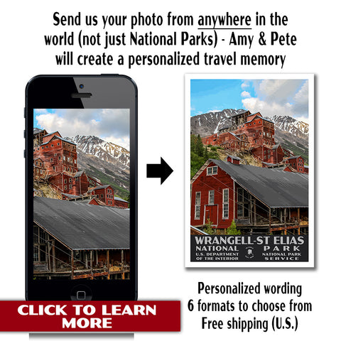
- When you return from your trip to Alaska, contact us to make a custom, vintage-style travel poster using one of your own photos!