6 Best Hiking Trails in Pawtuckaway State Park: Trail Maps, Directions & More
Peter BrahanOne of our favorite activities to really get out and see an area is hiking. Being from New Hampshire, spending a day hiking in Pawtuckaway State Park is a great way of exploring the area, seeing great views and clearing our minds from our busy lives.
The network of trails in Pawtuckaway State Park is impressive for this relatively small park. Most of the trails lead up to one of two mountains (South Mountain, the most popular, as well as North Mountain). Both have great views, and the great thing about it is that you can combine one or more of the trails and make each hike as long as you want!
It can be hard to figure out what to hike in Pawtuckaway State Park, and we hope this guide helps you narrow down what is best for you and your unique situation!
HIKING IN PAWTUCKAWAY STATE PARK: PREPARATION
The hikes in Pawtuckaway State Park do require you to be prepared. Don’t be fooled by the relatively short length on some of these hikes-they are steep in spots and you will get tired! Here are a few key pointers:
- Pack plenty of water. New Hampshire can be quite humid and hot in the summer in particular, and you will be appreciative of having plenty of water on the trail. Even if you are taking one of the shorter hikes, be prepared!
- Virtually all the hikes here involve rocks and hiking over roots. Wear closed-toed shoes at a minimum, but we recommend something with ankle support to be sure you can handle any inconsistencies in the trail.
- The trails here are buggy, so bring bug spray if you are hiking in the early summer in particular.
HIKING TRAILS IN PAWTUCKAWAY STATE PARK: DISTANCES AND ELEVATION GAINS
There are a few hikes in the park, and selecting the exact right one for you isn’t simple. However, we put together this chart to help at least narrow down the right hike for you, which compares elevation gain and distance for each hike mentioned in this article.

HIKING TRAILS IN PAWTUCKAWAY STATE PARK: TRAIL DESCRIPTIONS AND TRAIL MAPS
SOUTH MOUNTAIN LOOKOUT TRAIL
- Difficulty: Moderate
- Distance (round-trip): 4.6 miles
- Elevation gain: 820 feet
- Hiking time (approximate): 2.5 to 3 hours
- Trail type: Out-and-back
- Potential hazards: Bugs, sun exposure
- Restrooms: No restroom facilities are located at the trailhead. You have to use the restroom at the main visitor center close to the park entrance. No restrooms are on the trail.
- Recommended footwear: Hiking shoes or hiking boots due the rock scrambling, steepness of the trail and potential for wet conditions.
- Pets: Allowed, but must be kept on a leash at all times.
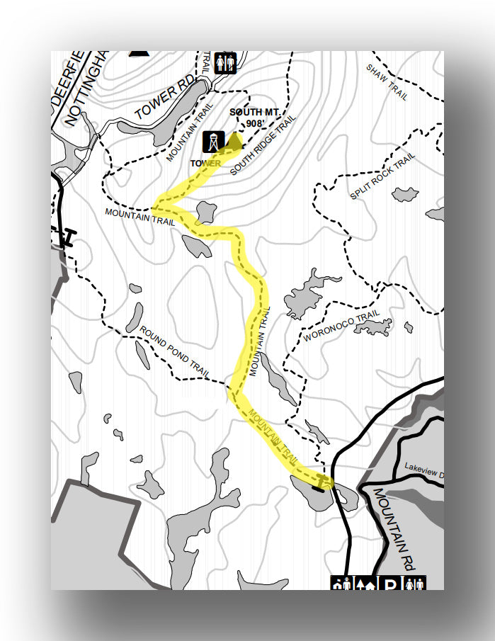
South Mountain Lookout Trail map, courtesy of New Hampshire State Parks
Trail Description
Everyone wants to have a hike end with a great view, and hiking to the Pawtuckaway Fire Tower is a great end point to do so! On this moderate hike, you’ll travel about 4.6-miles (round-trip) with an elevation gain of 820 feet.
The hike starts by heading down the Mountain Trail and is relatively flat before turning to the north at the 0.5-mile point (you’ll stay on the Mountain Trail). You’ll then start to gain elevation slowly before reaching the turnoff point at the 1.8-mile point. Here you’ll take a right on the South Ridge Trail and head up in elevation quickly before reaching the Fire Tower. From here you’ll have great 360-degree views. There are a number of spots to stop and take a break or eat your lunch. You can come back the same way you came, or you can keep heading to the east for 0.2-miles before turning back to the left (west), eventually meeting up with the trail you came in on. This extends the hike to 5.0-miles.
South Mountain Lookout Trail Highlights
- Stunning Views: The views from the fire tower are some of the best in the park. You’ll be able to see all around you!
- Well-marked and well-maintained: This trail is marked really well, making it easy to find your way. We do recommend having a map with you, or at least taking a photo of the map ahead of time to be sure that you take the right turns.
South Mountain Lookout Challenges
- Crowds: This is the most popular hike in the park, so it can get very busy, particularly with over a million visitors to the park each year.
- Lack of parking and facilities: Parking is a bit away from the trailhead, and there are no restrooms, which means you have to get here early and plan ahead!
Trailhead Directions
The South Mountain Lookout trailhead starts near Mountain Brook Pond off State Park Road. Note: You can also combine this trail with the North and South Mountain Loop, but the length increases to 9.5-miles (round-trip) and 1670 feet of elevation gain.


NORTH AND SOUTH MOUNTAIN LOOP
- Difficulty: Moderate / Hard
- Distance (round-trip): 6.1 miles
- Elevation gain: 1300 feet
- Hiking time (approximate): 3 to 4 hours
- Trail type: Loop
- Potential hazards: Bugs, sun exposure
- Restrooms: A toilet is located at the trailhead.
- Recommended footwear: Hiking shoes or hiking boots due the rock scrambling, steepness of the trail and potential for wet conditions.
- Pets: Allowed, but must be kept on a leash at all times.

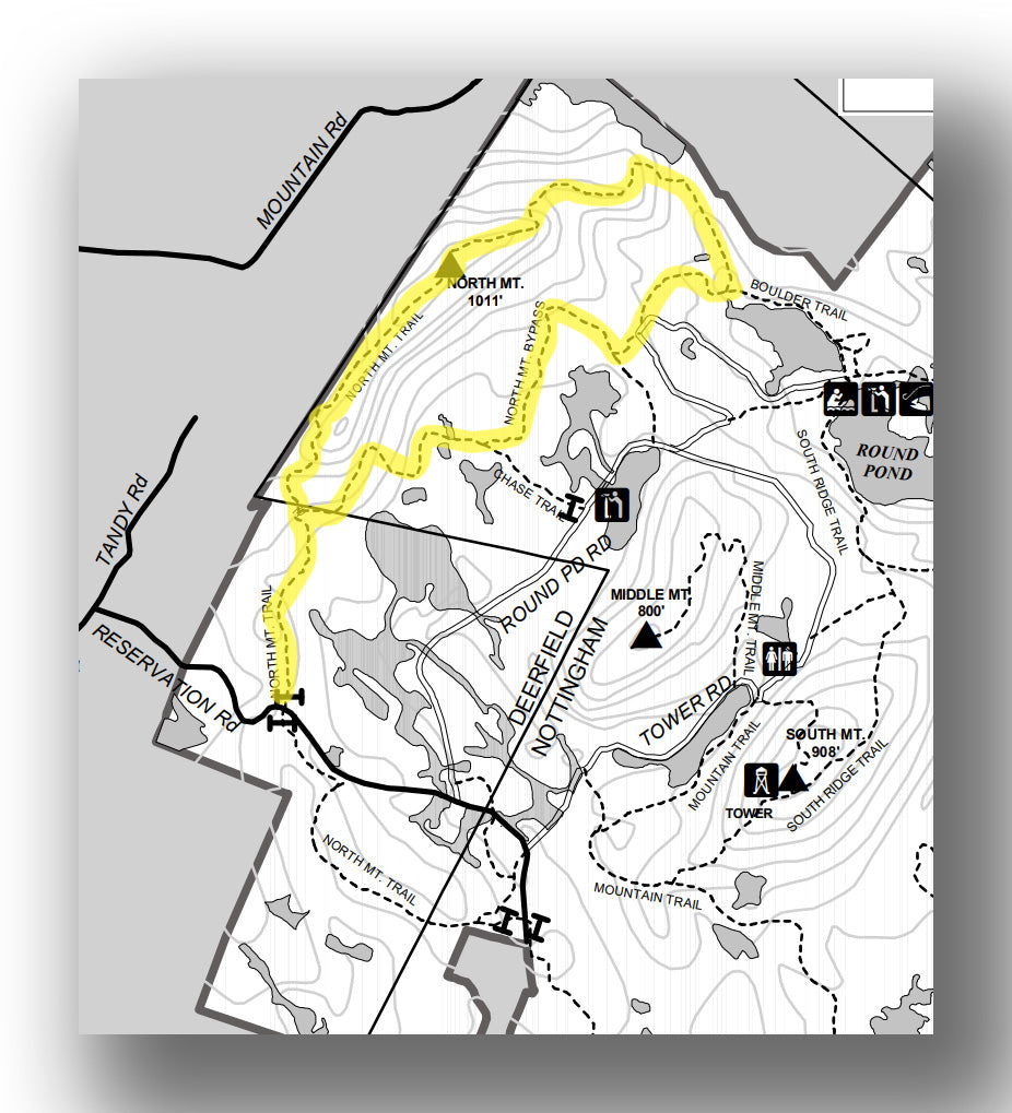
North and South Mountain Loop Trail map, courtesy of New Hampshire State Parks
Trail Description
If you are in for a bit of a longer hike, this is a great option. At 6.1-miles (round-trip) with a total elevation gain of 1300 feet, this hike hits two peaks. You can hike in either direction, and this hike is highlighted by the Pawtuckaway Fire Tower on South Mount Pawtuckaway as well as the view from North Mount Pawtuckaway, which is over 1000 feet in elevation. Most of the inclines are not too steep, but they do get steeper as you approach each of the peaks.
North and South Mountain Loop Trail Highlights
- Diverse Scenery: We love the fact that this trail includes a hike through a beautiful forest as well as stunning views from two mountain peaks.
- Challenging but not too hard: The trail will get your heart pumping, but it’s not overly challenging and is doable if you are steady on your feet and wear proper footwear.
North and South Mountain Loop Challenges
- Crowds: The South Mountain peak in particular can be quite busy. North Mountain is a bit quieter. Still, you can find a good spot to be out on your own when you take breaks.
- Strenuous in spots: I know we just said it’s not overly difficult, but there are some spots that are quite steep that you just need to be careful on.
Trailhead Directions
The North and South Mountain Loop starts at the end of Reservation Road on the northwest side of the park, but you can really start hiking this trail in a number of places throughout the loop.

NORTH MOUNTAIN LOOP TRAIL
- Difficulty: Moderate
- Distance (round-trip): 5.0 miles
- Elevation gain: 860 feet
- Hiking time (approximate): 3 hours
- Trail type: Loop
- Potential hazards: Bugs, sun exposure
- Restrooms: No restroom facilities are located at the trailhead nor are they on the trail.
- Recommended footwear: Hiking shoes or hiking boots due the rock scrambling, steepness of the trail and potential for wet conditions.
- Pets: Allowed, but must be kept on a leash at all times.
North Mountain Loop Trail map, courtesy of New Hampshire State Parks
Trail Description
If you don’t have time to hike both to North and South Mountains, then this is a great moderate trail. At 5.0-miles (round-trip) with an elevation gain of 860 feet, this trail gets you to the top of North Mountain. Start by hiking to the north on the North Mountain Trail before hiking up to the ridge and getting to the top of North Mount Pawtuckaway at the 1.4-mile point. You can turn around here or keep heading east for the full loop, coming back on the North Mountain Bypass Trail.
North Mountain Loop Trail Highlights
- Great Views: The views from North Mountain are amazing. Though there isn’t a fire tower like South Mountain, the views here are great.
- Fewer People than South Mountain: South Mountain tends to draw many more people, so this trail is a bit less crowded, which is nice.
North Mountain Loop Challenges
- Lack of Restrooms: It’s unfortunate that there are no restroom facilities at the trailhead.
- Crowds: Though less crowded than South Mountain, this part of the park is still pretty busy. We recommend hiking on a weekday if you can.
Trailhead Directions
The North Mountain Loop starts at the end of Reservation Road on the northwest side of the park.
MOUNTAIN TRAIL TO SOUTH RIDGE TRAIL LOOP
- Difficulty: Easy / Moderate
- Distance (round-trip): 1.5 miles
- Elevation gain: 410 feet
- Hiking time (approximate): 1 hour
- Trail type: Loop
- Potential hazards: Bugs, sun exposure
- Restrooms: Restroom facilities are located at the trailhead.
- Recommended footwear: Hiking shoes or hiking boots due the rock scrambling, steepness of the trail and potential for wet conditions.
- Pets: Allowed, but must be kept on a leash at all times.
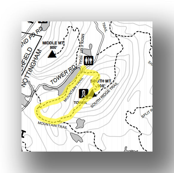
Mountain Trail to South Ridge Trail Loop map, courtesy of New Hampshire State Parks
Trail Description
This easy/moderate hike is a 1.5-mile (round-trip) loop that climbs just over 410 feet to the top of South Pawtuckaway Mountain. From the parking lot, the fastest way up to the Fire Tower is to take the Tower Trail. You’ll reach the peak at the 0.4-mile point. You can turn around here or make a loop out of it by heading down the South Ridge Trail and back to the parking area on the Connector Trail / Mountain Trail.
Mountain Trail to South Ridge Trail Loop Highlights
- Short Hike with Good Views: We’ve said it enough that the views from South Mountain are great, but this hike allows you to see them without spending too much time on the trail.
Mountain Trail to South Ridge Trail Loop Challenges
- Crowds: Since this is the shortest hike to the top, be prepared for it to be very busy. The one thing that keeps crowds not as bad as they would be is the fact that the trailhead is in a more remote part of the park.
- Steep Sections: While short, this hike still does require you to scramble a bit, so just be sure you have proper footwear and take things slow.
Trailhead Directions
The Tower trailhead starts at the parking area on Tower Road.
SOUTH MOUNTAIN AND WORONOCO LOOP TRAIL
- Difficulty: Moderate / Hard
- Distance (round-trip): 7.6 miles
- Elevation gain: 1030 feet
- Hiking time (approximate): 4 hours
- Trail type: Loop
- Potential hazards: Bugs, sun exposure
- Restrooms: No restroom facilities are located at the trailhead. You have to use the restroom at the main visitor center close to the park entrance. No restrooms are on the trail.
- Recommended footwear: Hiking shoes or hiking boots due the rock scrambling, steepness of the trail and potential for wet conditions.
- Pets: Allowed, but must be kept on a leash at all times.
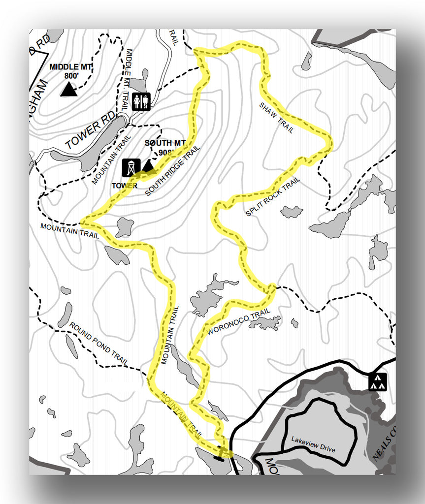
South Mountain and Woronoco Loop Trail map, courtesy of New Hampshire State Parks
Trail Description
This moderate/hard hike travels 7.6-miles (round-trip) and gains just over 1030 feet. After hiking up the Pawtuckaway Fire Tower, continue down from the peak on the South Ridge Trail before returning back on the flat Shaw Trail and Split Rock Trail before finally picking up the Woronoco Trail and heading back to the parking area. This trail has great views from the fire tower, but the rest of the walk is in the woods and is known for being both muddy and buggy in certain times of the year.
South Mountain and Woronoco Loop Trail Highlights
- Fewer Crowds: While the top of South Mountain will be busy, much of this trail is less crowded than other trails in the park.
- Amazing Views: You get to enjoy the incredible views of South Mountain as well as pretty scenery along the way.
South Mountain and Woronoco Loop Trail Challenges
- Crowds: The peak of South Mountain and the trail around it will be quite busy if you go during the peak season.
- Long: The hike is good, but some may find it a bit long for getting the same payoff that you do on some of the shorter trails.
Trailhead Directions
The trailhead starts near Mountain Brook Pond off State Park Road.

ROUND POND TRAIL TO SOUTH RIDGE
- Difficulty: Moderate
- Distance (round-trip): 4.5 miles
- Elevation gain: 790 feet
- Hiking time (approximate): 4.5 hours
- Trail type: Out-and-back
- Potential hazards: Bugs, sun exposure
- Restrooms: No restroom facilities are located at the trailhead. We recommend using the restroom in town at a gas station ahead of your hike.
- Recommended footwear: Hiking shoes or hiking boots due the rock scrambling, steepness of the trail and potential for wet conditions.
- Pets: Allowed, but must be kept on a leash at all times.
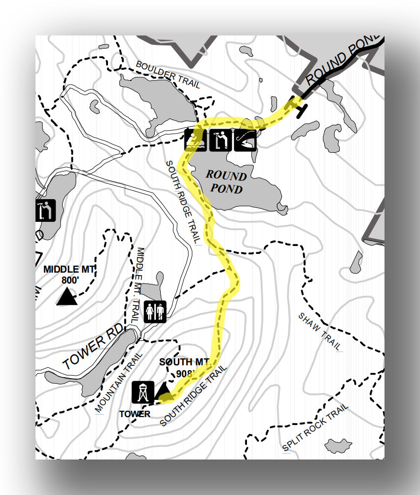
Round Pond Trail to South Ridge Trail map, courtesy of New Hampshire State Parks
Trail Description
This is a different approach to the Pawtuckaway Fire Tower. This 4.5-mile (round-trip) moderate trail starts by heading west on the Round Pond Trail. You’ll pass by Round Pond before turning south and picking up the South Ridge Trail and then climbing up to South Ridge. The elevation gain is about 790 feet.
Round Pond Trail to South Ridge Highlights
- Scenic and Serene: This views from the top of South Mountain are amazing, but it’s nice to have the serenity of the pond. Most of the other trails only have mountain and forest views, so this is a nice addition.
- Accessibility for Children: If you just want to go on a shorter hike and head to Round Pond, that is perfect for young families.
Round Pond Trail to South Ridge Challenges
- Buggy: The addition of water around the trail brings bugs! Just be prepared, or go during some of the cooler months or late summer and that will help out.
- Crowds: Of course, you’ll have plenty of people to contend with at the top of the ridge. But the walk to it along the pond will be pretty quiet.
Trailhead Directions
The Round Pond Trailhead is at the end of Round Pond Road off Deerfield Road.
THE BEST FAMILY-FRIENDLY HIKES IN PAWTUCKAWAY STATE PARK
To be completely honest, hiking in the Pawtuckaway State Park with children can be a bit of a struggle. There are bugs and many of the trails are long, so you have to be prepared and also ensure your kids are up for the challenge. Still, there are a few good hikes that we’d recommend with young families:
- Round Pond Trail (short with a good variety of scenery, plus you have the opportunity to see wildlife at the pond)
- Mountain Trail to South Ridge Loop (combines the good views of the other trails but quite a bit shorter)
ARE PETS ALLOWED ON THE TRAILS PAWTUCKAWAY STATE PARK?
Pets are allowed on all trails in Pawtuckaway State Park. however, you must have them leashed at all times. It’s also important to know that while pets are allowed on the hiking trails, they are not allowed on the beach or campground between May 1 and September 30.
WHEN IS THE BEST TIME OF YEAR TO HIKE AT PAWTUCKAWAY STATE PARK?
It’s hard to pick the perfect time of year for hiking in Pawtuckaway State Park, as it really depends on your preferences. The winter is nice as the trails are nearly empty, so if you are looking for solitude, that is perfect! In the summertime, colors are vibrant greens. However, it can be hot and buggy, particularly early on in the summer (the bugs tend to die down in August).
If we were to pick our personal favorite time to hike in Pawtuckaway State Park, we’d have to say the fall (specifically, the 2nd week of October). Fall colors are at their peak around this time, the trails are relatively cool and the crowds that are known to be present in the summer aren’t there. It can still be quite busy, so if you can hike on a weekday, we recommend doing that.
PAWTUCKAWAY STATE PARK HIKING RESERVATIONS
Believe it or not, if you do plan on hiking in the park during the peak summer and fall months you do need to get reservations ahead of your visit. Over 1 million come to the park each year (not for hiking, but also for camping and swimming), so you do want to be sure you are not left out because of not planning ahead!
You can get reservations up to 30 days in advance: Pawtuckaway State Park hiking reservations.
FURTHER INFORMATION ON PAWTUCKAWAY STATE PARK FROM JUST GO TRAVEL STUDIOS
- We have other great information on the park, including Things to Do in Pawtuckaway State Park as well as our blog on Camping in Pawtuckaway State Park.
- When you are done with your day of exploring the park and hiking trails, send us a photo and we’ll create a custom, vintage-style posters for you with your own custom photo and custom wording that we’ll personalize just for you (with unlimited edits!).