Devils Bridge Trail in Sedona
Peter BrahanIt’s no wonder why the hike to Devils Bridge in Sedona, Arizona is one of the most popular hikes in the area. It’s only moderately difficult, fairly short and has a payoff that is unlike most other hikes you will ever go on. And if you do end up hiking this trail, then you’ll undoubtedly end up with a photo that you’ll want to put on your wall. Guaranteed.
There are a few options for you to consider for your hike to Devils Bridge. The actual Devils Bridge Trail is short, but since most people heading to the trail do not have an off-road vehicle, hikers have to walk in on one of two trails. Don’t worry, though-the walk in is easy, and only extends the hike a bit.
Whatever route you take in, you’re sure to love the hike and we highly recommend heading out to this amazing natural landmark.
DEVILS BRIDGE TRAIL DETAILS
- Difficulty: Moderate
- Distance: 4.0 miles (with hiking on the Dry Creek Road from the Dry Creek Trailhead), 4.2 miles (hiking from the Mescal Trailhead), 1.6 miles (if driving in with a 4x4 to the trailhead) (in all cases, distances are round-trip)
- Trail: Out-and-back
- Elevation gain: 515 feet
- Peak elevation reached: 4,979 feet
- Best time of year to hike: Spring and fall
- To beat the crowds: Arrive before 7:00 am or after 5:00 pm
- Footwear: Hiking boots
- Watch out for: Sun exposure
- Restrooms: Located at the trailhead, but not on the trail
- Pets: Allowed, but must be leashed
- Time needed: 2 to 2.5 hours
DEVILS BRIDGE TRAIL RESERVATIONS AND PERMITS
You do not need reservations to hike the Devils Bridge Trail, but you do need a Red Rock Pass. You can get a Red Rock Pass online. It is also available at some trailheads, but not at either of the Devils Bridge Trailheads. Finally, you can also purchase the pass at some of the local stores in and around Sedona. For a full list of where you can buy the pass in the area, click here.
You may be tempted to risk it and not get a pass, but be advised that they do ticket cars frequently. It’s likely that when you are hiking that the area will be patrolled by the authorities.
We highly recommend getting one a day or two ahead of your visit, just so you don’t have to worry about it when you get to the trail and are ready to hike! Trust us, if you get a parking spot you will not want to give it up to go and get a pass that you could have purchased well ahead of time.
PARKING AND TRAILHEAD FOR THE DEVILS BRIDGE TRAIL
Devils Bridge Trail parking area, courtesy of the U.S. Forest Service
When you hike to Devils Bridge, you have three options to consider:
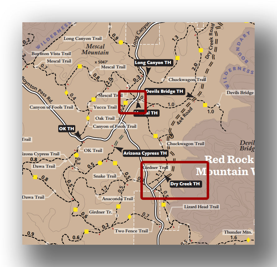
- Mescal Trailhead: If you park at the Mescal Trailhead, you’ll be on a hiking trail the entire way. It is located on Long Canyon Road, just north of the intersection with Boynton Pass Road. There are about 25 parking spots, and people also commonly park along Boynton Pass Road. It is also the same parking area as the Birthing Cave Trail. Directions from Sedona to the Mescal Trailhead. This will take about 15 minutes, with traffic.
- Dry Creek Trailhead: This trailhead will require you to hike in on Dry Creek Road, which turns into a 4x4 trail just after the parking area. The parking area is located on Dry Creek Road, just north of the intersection with Boynton Pass Road. The parking lot is a bit larger and more established, with about 50 parking spots. Directions from Sedona to the Dry Creek Trailhead. This will take about 13 minutes, with traffic.
- Drive on Dry Creek Rd. to the Devils Bridge Trail: Just past the Dry Creek Trailhead parking area, the Dry Creek Trailhead turns into a 4x4 trail. It gets pretty technical right away. If you have a high clearance rig or an OHRV, then it won’t be a problem. However, if you have a rental car or a stock SUV, you will likely want to take a pass on trying this road. For perspective, only about three cars attempted this route while we were there, and there were a ton of people out hiking.
In all cases, you can expect the Mescal Trailhead and Dry Creek Trailhead to fill up fast. On a day with good weather, you can expect the parking areas to be full by 7:00 am, and that’s no joke. Parking extends outside of the lots, but just be sure to check the local signage to see where you are allowed to park. Even if you don’t park in the lot, you still need to have a Red Rock Pass, so don’t forget that!
We recommend taking the first spot that you see. It’s not unheard of for people to have to walk 0.5-miles from where they parked to get to the trailhead!
There is a pit toilet at the Dry Creek Trailhead, but none on the trail or at the other trailheads.
DEVILS BRIDGE TRAIL: TRAIL SURFACE AND ACCESSIBILITY
- Trail surface. The trail is packed dirt. Once you get to the Devils Bridge Trail, it climbs steadily with rocks that you have to ascend (like very tall stairs made of rock), so you have to be sure on your feet.
- Accessibility. The trail is not wheelchair accessible.

PREPARATION FOR HIKING THE DEVILS BRIDGE TRAIL
This hike is not overly long, but you should plan on being out here for a couple hours. If you haven’t eaten recently, bring plenty of snacks. You may also have a bit of a wait at the bridge to get a picture, so keep that in mind as you prepare. We of course recommend bringing a few things in particular:
- Water. No matter what time of year you are hiking, it’s dry in Sedona and you will need to bring with you plenty of water.
- Sun protection. You will be able to find some shade on this hike, but most of it is very exposed. Wear a hat and bring sunblock.
- Red Rock Pass. You can’t get a Red Rock Pass at the trailhead and you need one. You can get one in a local shop, or online.
- Camera. Okay, normally a phone is fine, and if that’s all you have then that’s fine. However, to get the best photos on the bridge, it helps to have a bit of a zoom lens.
- Footwear. Be sure to wear sturdy shoes or hiking boots to avoid hurting yourself while coming down the trail, in particular.
HIKING THE DEVILS BRIDGE TRAIL
Devils Bridge Trail, courtesy of the U.S. Forest Service
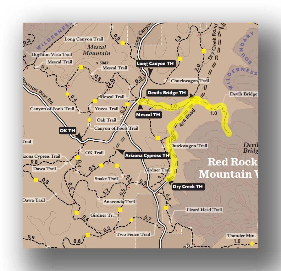
After parking and heading in on either the Mescal Trail or the Dry Creek Road walk, you’ll arrive at the Devils Bridge Trail.
You’ll know you are at the Devils Bridge Trailhead by the sign and the small parking area (on dirt) and likely a few hefty vehicles parked here that were bold enough to take the drive in. The Mescal Trail climbs in elevation about 180 feet, and the Dry Creek Road is pretty much flat the entire way in. In any case, the hike to the trailhead is pretty easy. While some may not consider the walk on the Dry Creek Road to be amazing, it certainly still is pretty and it goes by fast.


Once you arrive at the Devils Bridge Trail, you’ll head east. The first part of the trail is quite flat.

After hiking about 0.5 miles, the trail starts to head up fairly steeply. The trail becomes similar to climbing rock stairs, and that lasts for the next 0.3 miles before you are able to finally see Devils Bridge. In this span of 0.3 miles the trail gains 300 feet. While that may not seem like a lot, it does create a challenge for quite a bit of people. There aren’t any great resting spots as the trail is quite narrow, so if you do need to take a break, watch your step as you move to the edge of the trail.
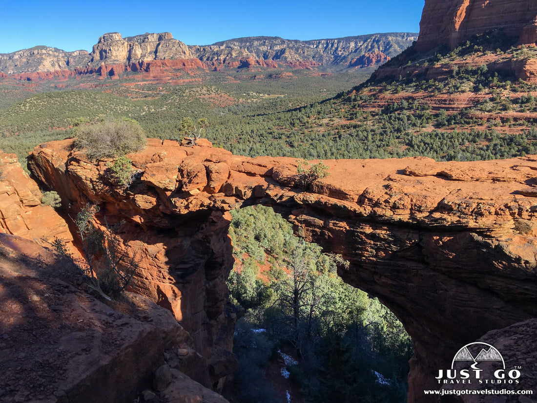
Once you get to the bridge area, the scenery is amazing. The view opens up to the north, allowing for a great backdrop as you take photos of the bridge.

Now, many people want to get their photos taken while they are on the bridge. If you are here when it’s busy, you’ll have to wait in line. Be patient, and when it’s your turn be brief on the bridge, but be careful! The bridge is not that wide and has quite the drop.

When we visited, it was common to give your camera to someone else in line who can take a photo with your crew on the bridge. This worked out well for us!
The hike back goes quickly, but just be careful as you descend. The steps going down can be a bit of a challenge as they are quite steep so be sure to take your time.

ABOUT DEVILS BRIDGE
You may wonder, how long and how high is Devils Bridge and how was it formed? Devils Bridge is a sandstone arch, and was formed by weather erosion. The bridge is 45 feet long, about 55 feet tall and is about 5 feet wide.
DEVILS BRIDGE TRAIL: TOP LIKES AND DISLIKES
Likes:
- Incredible, Accessible, Iconic Feature. It’s pretty rare when you can get on top of an arch, especially one that is this easy to hike to. In just an hour or so of hiking you can be at this amazing arch!
- Unbelievable Photos. If you want to get that shot that you can put on a holiday card, this is it! People won’t believe you were actually on an arch that is this high above the ground.
Dislikes:
- Crowds. Above all, the biggest thing we didn’t like was how many people there are on the trail. We got here early and were the second group at the bridge for the day, but on the way back lines were already starting to form at the bridge.
- Parking. The parking area here fills up fast, and it can be a bit hectic.
FURTHER INFORMATION ON SEDONA, ARIZONA FROM JUST GO TRAVEL STUDIOS
- Aside from Devils Bridge, there is a ton in the area. Be sure to check out our blog on What to See and Do in Sedona, Arizona.
- A good hike nearby that you should consider is the Cathedral Rock Trail. Just to the north is the famous Slide Rock State Park, which is a great place to check out as well!
- We also have a number of great blogs on What to See and Do in Arizona.
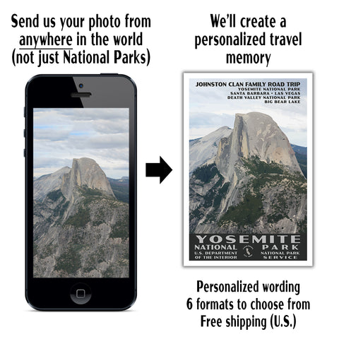
- After your trip, if you have taken an amazing photo or two, send them to us and we’ll create a vintage-style travel poster! If you love remembering your trips, this is a great way to do so forever!