13 Best Hiking Trails in Colorado National Monument: Trail Maps, Directions & More
Peter BrahanHiking in Colorado National Monument is one of the best ways of really getting yourself immersed in this beautiful landscape. While it’s just one of the many Things to Do in Colorado National Monument, it’s certainly our favorite thing to do in the park! The trails here are well marked, plentiful and generally not overly crowded.
It’s hard to pick out the best hikes in Colorado National Monument, but we did our best at picking out the ones that we thought were definitely worth doing. They range from easy to on the more difficult side, so there really is something for everyone.
In this article, we’ll cover the distances, elevation gains, how much time it will take, show you our hiking maps that we’ve prepared and give a bit of information about each of the trails that you’ll encounter.
HIKING IN COLORADO NATIONAL MONUMENT: PREPARATION
Keep in mind that before you head out on any hike at Colorado National Monument that you should be safety aware. That means:
- Plan out your hiking route and carry a map. Cell service varies widely throughout the monument.
- Since the monument is set in an arid, desert environment, hikers should always carry plenty of water. The only water sources inside the monument are at the visitor center and picnic areas. There are no water sources on trails. For those headed out on long hikes, one gallon per person, per day is recommended.
- Come prepared with sun protection since there is little shade on most of the trails in the monument.
- Elevations at the monument range from 4,000 to almost 7,000 feet, so even the shortest trails can seem challenging for visitors not acclimated to high altitudes. Consider the elevation and your fitness level when selecting a hiking trail.

HIKING TRAILS IN COLORADO NATIONAL MONUMENT: DISTANCES AND ELEVATION GAIN
It’s always hard to figure out the right hike for your skill level and how much time you have. To help out, we put together a couple of charts for you to reference as you try to pick out the right hike.
To start off, we have a graph of the many easy hikes in Colorado National Monument.

If you are up for something a bit more challenging, check out our moderate to hard hikes that we have plotted out for Colorado National Monument.

HIKING TRAILS IN COLORADO NATIONAL MONUMENT: TRAIL DESCRIPTIONS AND TRAIL MAPS
WINDOW ROCK TRAIL
- Difficulty: Easy
- Distance (round-trip): 0.5 miles
- Elevation gain: 65 feet
- Hiking time (approximate): 30 minutes
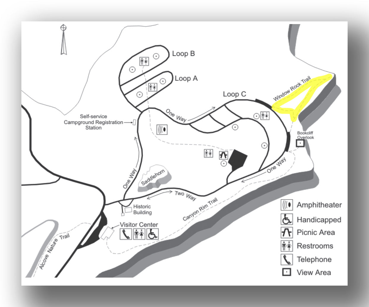
Window Rock Trail map, courtesy of the National Park Service
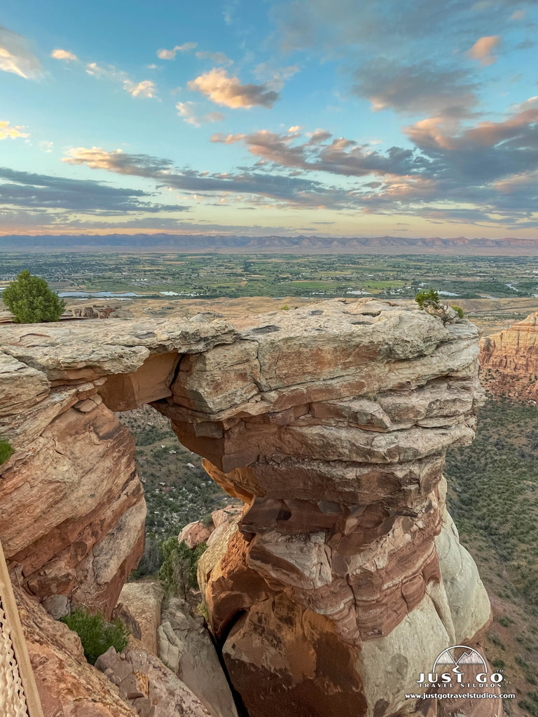
The short trail to view Window Rock is suitable for almost everyone! Follow the 0.25-mile one-way trail (0.5-miles RT) through a pinyon and juniper woodland to an overlook with spectacular views of both Wedding and Monument Canyons. From the fenced area at the end of the trail, take in views of Window Rock. Erosion formed and continues to shape this natural window in the canyon wall.
The marked trailhead for the Window Rock Trail is on the campground one-way road before the Book Cliffs View. Limited parking is available at the Window Rock trailhead. Allow 15 minutes for this hike.
CANYON RIM TRAIL
- Difficulty: Easy
- Distance (round-trip): 1.6 miles
- Elevation gain: 170 feet
- Hiking time (approximate): 1 hour
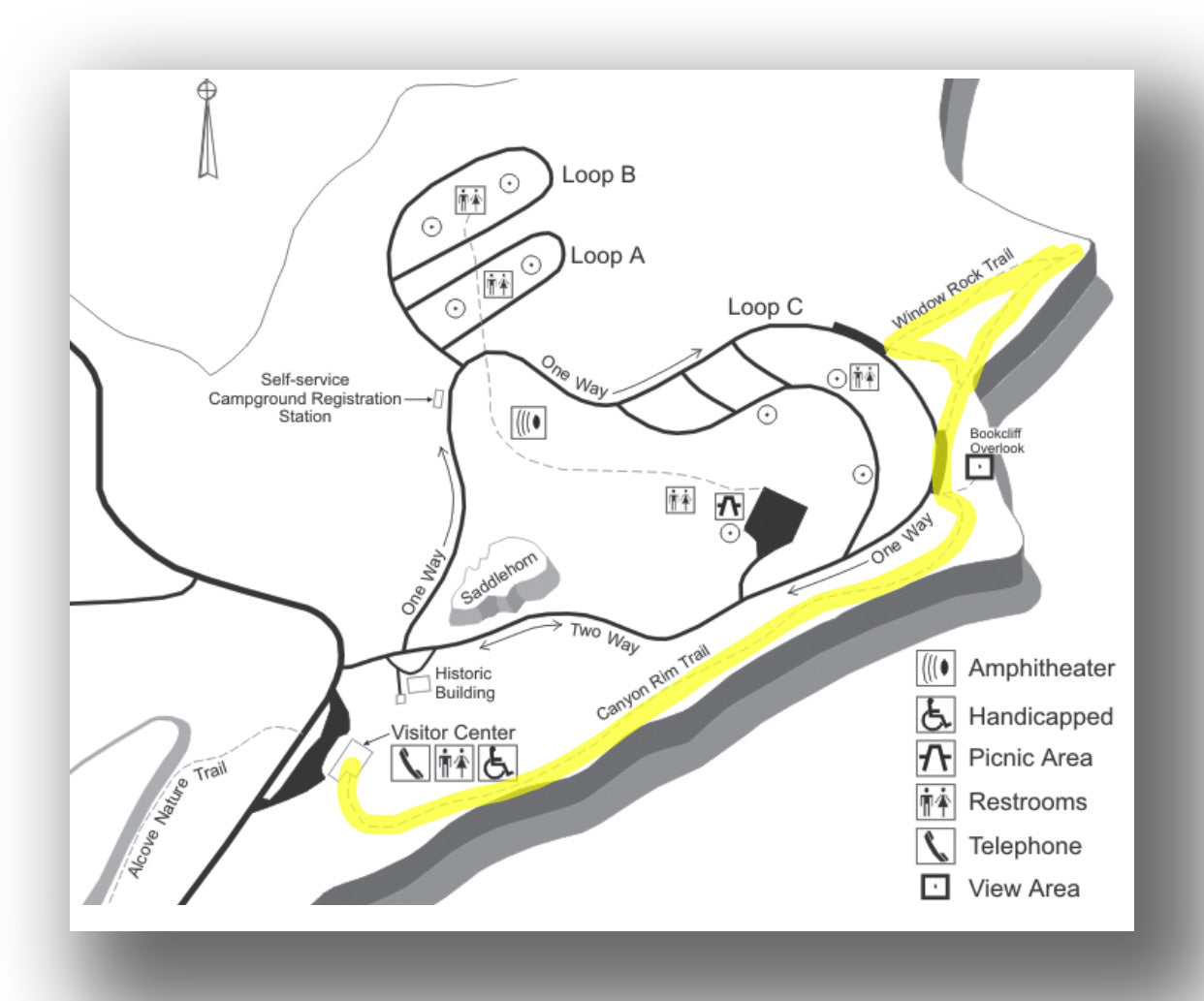
Canyon Rim Trail map, courtesy of the National Park Service
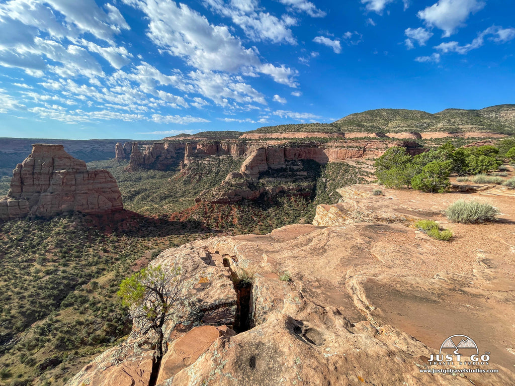
If you only have time for one easy hike while visiting the monument, we highly recommend combining the Canyon Rim Trail (0.5-miles one-way) with the Window Rock Trail (0.25-miles one-way). The Canyon Rim Trail departs from behind the Saddlehorn Visitor Center. Hike along a winding trail that borders the cliff edge of Wedding Canyon and leads to the stunning Book Cliffs View!
From here, you can continue hiking on the adjoining Window Rock Trail. We hiked the two trails and then looped back to the visitor center via the campground road, which took us about 40 minutes with LOTS of stops for photos. Roundtrip distance will vary (1-1.5 miles RT) depending on trails hiked and route taken to return to the visitor center. If you can time your hike with the golden hour (like we did), you won’t be disappointed! Just before sunset is a stunning time to enjoy views of the canyons!
The Canyon Rim Trailhead is located just behind the visitor center. There is plenty of parking at the visitor center. Allow about 30 minutes to explore Canyon Rim Trail or an hour to combine it with the Book Cliffs View and Window Rock Trail before looping back to the visitor center.
ALCOVE NATURE TRAIL
- Difficulty: Easy
- Distance (round-trip): 1.0 mile
- Elevation gain: Minimal
- Hiking time (approximate): 45 minutes

Alcove Nature Trail map, courtesy of the National Park Service
Another easy option near the visitor center is the Alcove Nature Trail. This 0.5-mile one-way trail (1 mile RT) is perfect for families with young children since it is short and mostly level. Guides are available at the trailhead with information about the plants, animals and rocks at the monument.
The Alcove Nature Trail starts across Rim Rock Drive from the Saddlehorn Visitor Center. Allow 20-30 minutes to walk the nature trail.
OTTO’S TRAIL
- Difficulty: Easy
- Distance (round-trip): 0.7 miles
- Elevation gain: 126 feet
- Hiking time (approximate): 30 minutes

Otto’s Trail map, courtesy of the National Park Service
For a short and easy trail with some of the best panoramic views at the monument, head to Otto’s Trail! This 0.7-mile (out-and-back) trail follows a gently sloped descent to an overlook with views across the Grand Valley. Look out towards rock formations that include Pipe Organ, Sentinel Spire and Independence Monument.
The trailhead for Otto’s Trail is about a mile past the visitor center on the left side of the road (if coming from the west). Allow 20-30 minutes for this hike.

COKE OVENS TRAIL
- Difficulty: Easy
- Distance (round-trip): 1.0 mile
- Elevation gain: 170 feet
- Hiking time (approximate): 45 minutes
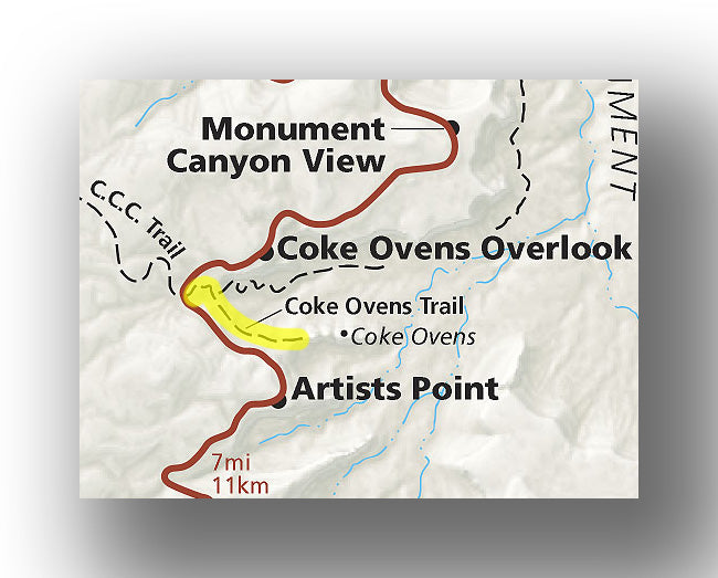
Coke Ovens Trail map, courtesy of the National Park Service
For a short and easy trail with some of the best panoramic views at the monument, head to Otto’s Trail! This 0.7-mile (out-and-back) trail follows a gently sloped descent to an overlook with views across the Grand Valley. Look out towards rock formations that include Pipe Organ, Sentinel Spire and Independence Monument.
The trailhead for Otto’s Trail is about a mile past the visitor center on the left side of the road (if coming from the west). Allow 20-30 minutes for this hike.

DEVILS KITCHEN TRAIL
- Difficulty: Moderate
- Distance (round-trip): 1.5 miles
- Elevation gain: 320 feet
- Hiking time (approximate): 1 hour
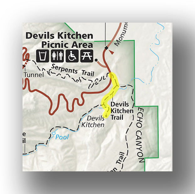
Devils Kitchen Trail map, courtesy of the National Park Service
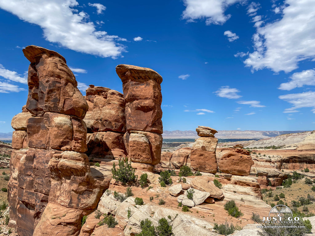
We didn’t have time to do all the hikes at Colorado National Monument, but this trail was a family favorite! The 0.75-mile one-way trail (1.5 miles RT) has incredible canyon views and some fun, rocky scrambles! However, it is best known for its namesake, the Devils Kitchen, an area with a dramatic cluster of upright boulders that feels like a giant rock room.
The first part of the trail is sandy and flat. Go right at the first fork in the shared trail and take a left at the second fork to continue towards Devils Kitchen. Cross the wash and begin the climb up the slickrock. (Heading up the canyon, you can see the top of the large rock grotto that is Devils Kitchen off to the left.) As you approach the base of the large rock formation (at the top of the climb), go left and hike towards Devils Kitchen. You can walk right through the natural opening and inside the circle of giant upright boulders!
The Devils Kitchen Trailhead is located 0.2 miles past the East Entrance (Grand Junction). Limited parking is available at the shared trailhead for Devils Kitchen, No Thoroughfare Canyon and Old Gordon Trails. Additional parking is available at the Devils Kitchen Picnic Area. Allow 1-1/2 hours to enjoy the Devils Kitchen Trail. Since this hike also involves some climbing up slickrock, proper hiking footwear is recommended. Be aware: this trail is not well marked and can be challenging to follow. MANY have been confused by AllTrails and Gaia maps which were misleading at the time this was written. There are steep drop-offs, so do not hike beyond Devils Kitchen.
ECHO CANYON KITCHEN TRAIL
- Difficulty: Moderate
- Distance (round-trip): 3.0 miles
- Elevation gain: 499 feet
- Hiking time (approximate): 2 hours
Due to the popularity of its neighbor (Devils Kitchen), Echo Canyon is a great place to escape the crowds! The 1.5-mile one-way trail (3 miles RT) leads down to Echo Canyon’s lush and shady interior which can provide some relief from the sun on a warm day. Follow Old Gordon Trail for 0.5 miles to the junction and follow the leftmost trail which leads down the slickrock into Echo Canyon. Due to its longer distance plus several uphill and downhill portions, the Echo Canyon Trail is more challenging than the Devils Kitchen Trail.
The shared trailhead to reach Echo Canyon is located 0.2 miles past the East Entrance (Grand Junction). Limited parking is available on the left side of the road. Additional parking is available at the Devils Kitchen Picnic Area. Allow 2 about hours for this hike.
SERPENTS TRAIL
- Difficulty: Moderate
- Distance (round-trip): 3.5 miles
- Elevation gain: 782 feet
- Hiking time (approximate): 2 hours

Serpents Trail map, courtesy of the National Park Service
This historic trail follows the original road that was built to provide access to the Glade Park Plateau--before the completion of Rim Rock Drive in 1950. It was called the “Crookedest Road in the World” due to its many switchbacks. The 1.75-mile one-way (3.5 miles RT) trail climbs steadily until reconnecting with Rim Rock Drive—providing some excellent views along the way! This wide, well-maintained trail is frequented by locals.
The trailhead for Serpents Trail is located 0.2 miles past the East Entrance (Grand Junction) on the right side of Rim Rock Drive. Limited parking is available at the shared trailhead for Devils Kitchen, No Thoroughfare Canyon and Old Gordon Trails. Additional parking is available at the Devils Kitchen Picnic Area. Allow about 2 hours for this hike.
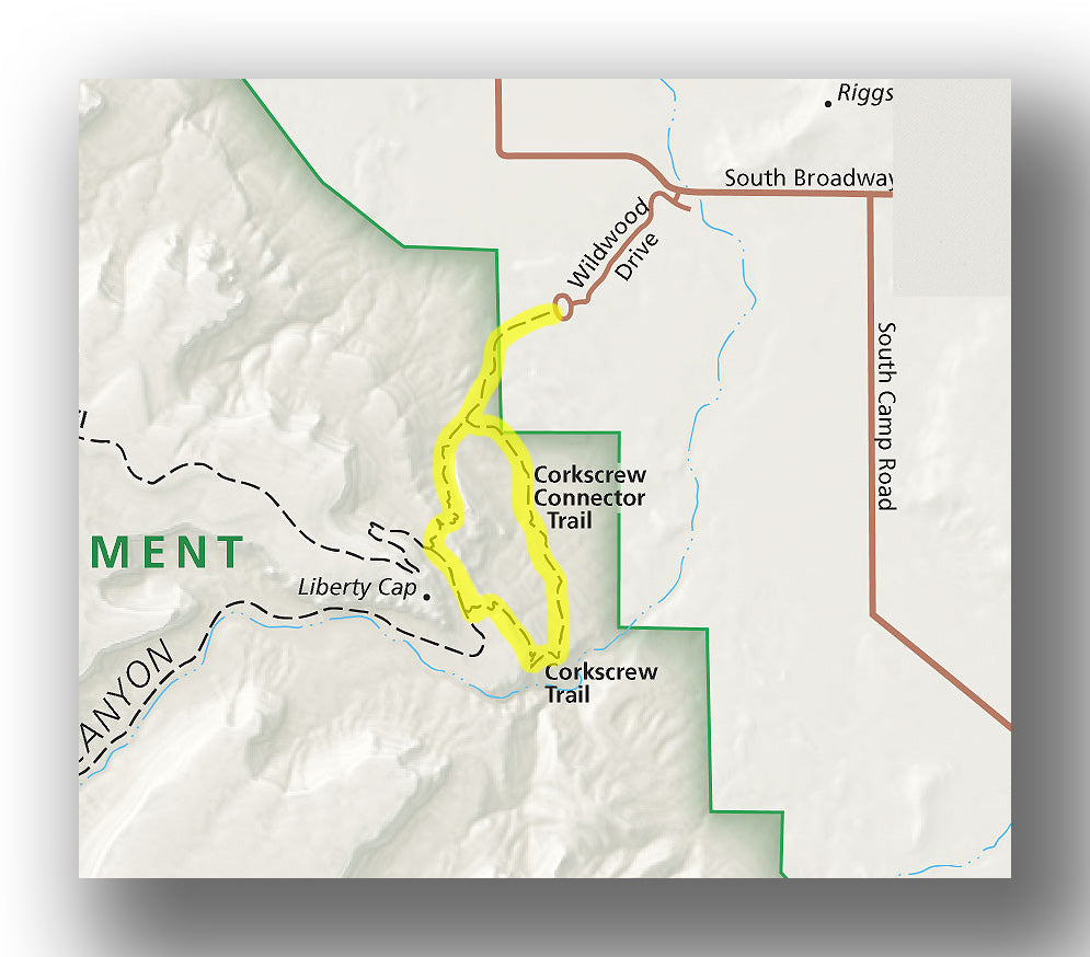
Corkscrew Trail Loop (Liberty Cap Trail, Ute Canyon to Corkscrew Trail)
3.8-mile loop. 2 ½ - 3 hours. Moderately strenuous. Steep drop-offs.
Monument Canyon Loop (Wedding Canyon and Monument Canyon Trails)
~6-mile loop (counterclockwise recommended due to some steep/loose rock sections on Wedding Canyon Trail). 3-4 hours. Moderately strenuous.
No Thoroughfare Canyon Trail
Length and estimated hike time varies. 8.5-miles one-way; however, most hikers turn back at the first pool/waterfall (seasonal) which is 1.1 miles one-way from the trailhead). Moderate to strenuous depending on the distance hiked. Past the first pool, the trail is unmaintained and primitive. Spring is the best season for this hike.
Ute Canyon Trail
11 miles RT (out-and-back hike from Wildwood Trailhead). Liberty Cap to Corkscrew Trail to top of Ute Canyon Trail and then back. Strenuous. 5-6 hours.
Monument Canyon Trail
11.6 miles RT (out-and-back hike from Lower Monument Canyon Trailhead to Upper Monument Canyon Trailhead). Strenuous. 5 ½ - 7 hours.
See the NPS website more information on these backcountry hiking trails and others.
FURTHER INFORMATION ON COLORADO NATIONAL MONUMENT FROM JUST GO TRAVEL STUDIOS
- We have a couple of other articles that are worth checking out, including our blog on Things to Do in Colorado National Monument and Camping in Colorado National Monument.
- When you return, we’ll create for you a custom, vintage-style poster that is personalized and made just for you!